Tropical Cyclone Jasmine's Eye Seen From Space

A dangerous tropical cyclone has been roaring through the South Pacific recently, but so far no casualties or damage has been reported.
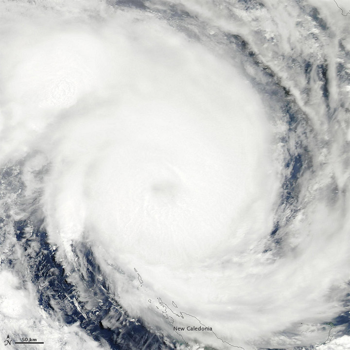
Tropical Cyclone Jasmine formed as a tropical storm over the South Pacific Ocean on Feb. 4, and strengthened to a tropical cyclone two days later. On Feb. 7, Jasmine's clouds stretched over the northern tip of New Caledonia, as can be seen in a new NASA satellite image.
The U.S. Navy's Joint Typhoon Warning Center (JTWC) reported that the storm had rapidly intensified, developing a ragged eye spanning 24 nautical miles (44 kilometers). Jasmine had maximum sustained winds of 115 mph (185 kph) and gusts up to 144 mph (230 kph).
In the South Pacific, a tropical cyclone is a storm with sustained winds of 35 mph (65 kph). A severe tropical cyclone has sustained wind speeds greater than 75 mph (120 kph). In the Atlantic basin, tropical cyclones are called tropical storms and hurricanes.
Jasmine is as strong as a Category 4 hurricane, and has clipped the island of Anatom, Vanuatu, according to AccuWeather.com.
Storms this strong can cause major damage by sending waters rushing inland, downing trees and power lines and structurally damaging buildings.
The Moderate Resolution Imaging Spectroradiometer (MODIS) on NASA's Aqua satellite captured the above natural-color image on Feb. 7. Spanning hundreds of kilometers, the storm sports a distinct eye.
Sign up for the Live Science daily newsletter now
Get the world’s most fascinating discoveries delivered straight to your inbox.
The JTWC forecast that Jasmine would move toward the southeast, past New Caledonia, before changing course toward the east. The storm was expected to modestly intensify over the next 24 hours, and then gradually weaken.
Follow OurAmazingPlanet for the latest in Earth science and exploration news on Twitter @OAPlanet and on Facebook.


