Warmest Spring in Years to Fuel Active Severe Weather

This article was provided by AccuWeather.com.
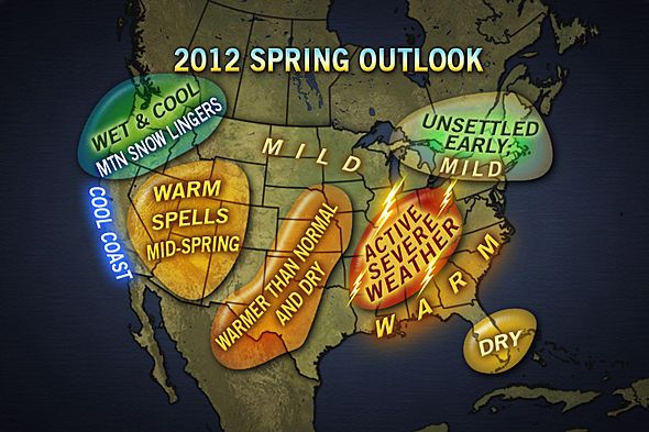
An active severe weather season is anticipated in the U.S. during spring of 2012 with the most widespread warmth since 2004.
"As far as the forecast for the spring of 2012, we do feel like it's going to be a mild spring for most of the nation from the eastern Rockies into the Ohio Valley and Great Lakes area," Paul Pastelok, expert long-range meteorologist and leader of the AccuWeather.com Long-Range Forecasting Team, said. "At least two-thirds of the nation could wind up with above-normal temperatures."
The Northeast will be mild to start, while the central Plains and western Texas will be a particularly warm zone this spring.
An exception to the mild weather will be the Pacific Northwest, where temperatures will be below normal.
Active Severe Weather Season Forecast
An above-normal number of tornadoes is forecast for this season with water temperatures in the Gulf of Mexico running above normal for this time of year. The active severe weather season follows a deadly year with a near-record number of tornadoes in 2011.
Sign up for the Live Science daily newsletter now
Get the world’s most fascinating discoveries delivered straight to your inbox.
Typically, 1,300 tornadoes strike the U.S. a year. There were nearly 1,700 tornadoes in 2011, falling short of the record 1,817 tornadoes set in 2004.
Rounds of wet weather with an active start to the severe weather season are in store for the Deep South, including eastern Texas and the Gulf states, during March.
The rain early in the season will be beneficial for drought-stricken areas, including southern portions of Louisiana, Mississippi, southern Alabama, southwestern Georgia and the western Florida Panhandle. Near-normal precipitation is expected in this zone for the entire spring.
"Areas that seemed to miss out on frequent severe weather last year may see an uptick this year," AccuWeather.com Expert Senior Meteorologist Dan Kottlowski said.
More frequent bouts of rain and severe weather will migrate northward to the mid-Mississippi and Ohio valleys, which were not hit as hard as the Deep South in 2011, mainly during April and May.
Above-normal rainfall is in store for the Tennessee and Ohio valleys as cooler, unsettled weather settles in the region during May.
"The Tennessee Valley wild card will be whether cut-off lows bring below-normal temperatures and unsettled weather to the region during May," according to Pastelok.
While portions of the South will have welcome rain and above-normal rainfall this spring, drought conditions may worsen in central and southern portions of Florida. Dry conditions are expected for central and southern Florida for most of the season. The increasing dry conditions may also lead to a high fire danger throughout this spring season.
"By the summer, the pattern in Florida may flip around with more episodes of wet weather," Pastelok added.
Warming Up in the Rockies, Plains
The central Plains and western and central parts of Texas will be particularly warm this spring, once a large dome of high pressure shifts westward and dominates the weather.
The change to drier, milder weather is expected to occur in April and May. Temperatures will climb above-normal, especially across Nebraska and Kansas and western and central Texas, with below-normal rainfall. The persistent dry and mild weather is not good news for the already drought-stricken Texas and the Four Corners region.
However, across eastern Texas, episodes of rain this winter have already begun to chip away at drought conditions. Some more episodes of wet weather, especially earlier in the season, will continue to provide some relief to communities in eastern Texas.
Farther north, following a devastating year of flooding for some areas of the Midwest in 2011, farmers and residents are likely wondering what this season will bring. Fortunately, there is a low risk of flooding this year for rivers in the northern Plains with a lack of substantial snowcover.
Warmth Early for the Great Lakes, Then Roller-Coaster Temperatures
"The spring [temperatures] will start out well above normal through the Great Lakes but may head into a back-and-forth pattern for April and early May, more of a typical spring," Pastelok said. "Snow chances will be limited through March with a small chance for a couple of events in April."
The Upper Peninsula of Michigan, northern Wisconsin and northern and central parts of the Lower Peninsula of Michigan will receive above-normal precipitation this spring.
Overall, despite some cool periods and chances of snow, most of the Great Lakes will end up with above-normal temperatures this spring. Chicago and Milwaukee will have above-normal temperatures and near-normal precipitation.
Unsettled Periods For Some in the Northeast; Mild
Spring fever alerts are issued for the Northeast with a mild start to the season expected for the balance of the region.
It will be a nice and mild March for the I-95 corridor, spanning Washington, D.C., Philadelphia, New York City and Boston. Cities across the interior Northeast, such as Pittsburgh and Buffalo, may even have a milder March than areas farther east.
Despite mild weather, there will still be some rain events in March, especially for the Appalachians.
Temperatures will flip-flop more during April and early May with some quick cool shots arriving before significant warming occurs late in May into June. With quick-moving storms, precipitation will turn out near normal.
Cool and Unsettled in the Northwest; Cool California Coast Seattle and Portland are both forecast to receive above-normal rainfall with a cool, unsettled weather pattern lingering during this spring in the Pacific Northwest.
"Mountain snow will linger in the Northwest, at times in the Sierra Mountains," Pastelok said about the early part of the spring.
Cool, damp weather could even last right through May with a storm track into the Northwest. "It will be a slow recovery on temperatures late in spring into the summer," added Pastelok.
While the interior valleys and deserts have near- to slightly above-normal temperatures this spring, the coastal areas will have a cool onshore flow from the Pacific. The marine layer will frequently bring in low clouds and fog late at night and during the morning for the coastal communities.
© AccuWeather.com. All rights reserved. More from AccuWeather.com.


