Earth from Space: Easter Island

On Easter Sunday in 1722, Dutch explorer Jacob Roggeveen became the first known European to encounter this Polynesian island and gave it the name it has become most widely known by.
Easter Island (also known as Rapa Nui in the native language) is one of the most isolated spots on Earth, lying some 2,000 miles from the nearest areas of human habitation (Tahiti and Chile) — even more remote than the astronauts orbiting at 210 nautical miles above the Earth.. The island, which is only 15 miles long, was annexed by Chile in 1888. (In Spanish, it is called "Isla de Pascua," which means "Easter Island.")
Archaeological evidence suggests that Polynesians from other Pacific Islands discovered and colonized Easter Island around the year 400.
The island and its early inhabitants are best known for the giant stone monoliths, known as Moai, placed along the coastline.
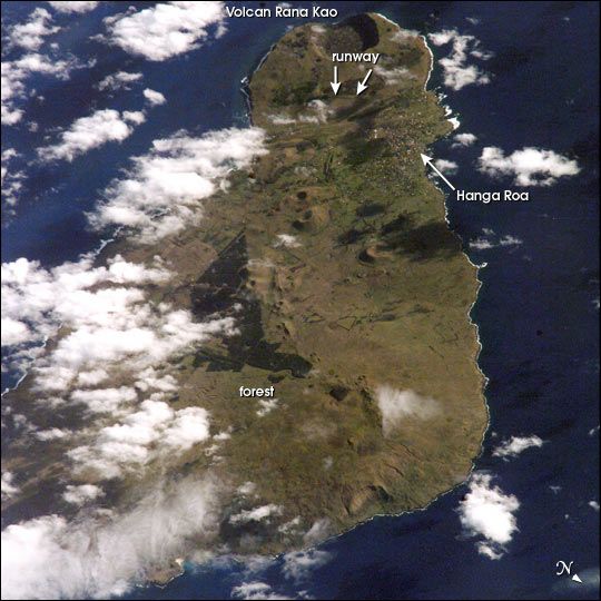
It is thought that the population grew bigger than was sustainable on the small island, resulting in civil war, deforestation and near collapse of the island ecosystem . Today, a new forest (primarily eucalyptus) has been established in the center of the island (the dark green in the image), according to a NASA statement.
Volcanic landforms dominate the geography of the island, including the large crater Rana Kao at the southwest end of the island and a line of cinder cones that stretch north from the central mountain. Near Rana Kao is the longest runway in Chile, which served as an emergency landing spot for the space shuttle before its retirement in 2011.
Sign up for the Live Science daily newsletter now
Get the world’s most fascinating discoveries delivered straight to your inbox.


