Images: Mexico's Popocatepetl Volcano
Risky Business
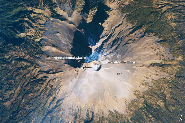
Popocatepetl, a large stratovolcano located approximately 70 kilometers southeast of Mexico City, is considered by many volcanologists to be "the planet's riskiest volcano." The volcano warrants this distinction because of how close it is to one of the most densely populated megacities on Earth: nearly 23 million people lived in Mexico City in 2009. The variety of potential volcanic hazards at Popocatepetl is also considerable, including explosive eruptions of ash, pyroclastic flows (hot, fluid avalanches of rock fragments and gas), and debris avalanches.
Together with the ice on nearby Iztaccíhuatl Volcano and Pico de Orizaba (Mexico's highest peak and the highest volcano in North America), Popocatepetl's glaciers are the only mountain glaciers in tropical North America. The glaciers create yet another volcanic hazard: dangerous mudflows, or lahars, if the ice were to melt during an eruption.
The Smoking Mountain
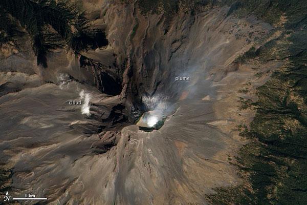
With a name that means "smoking mountain" in the Aztec language, Mexico's Popocatépetl does not disappoint.
The towering volcano, about 43 miles (70 kilometers) southeast of Mexico City, was emitting a faint plume of steam and gas on Jan. 4, 2011.
[Full Story: Mexico's Popocatepetl Lives Up to Its Name]
Constant Action
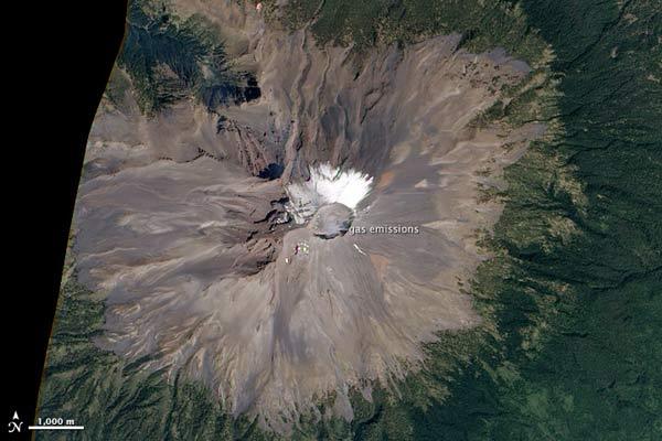
Popocatépetl has been erupting since January 2005.
The volcano, which towers over central Mexico, vents almost constantly from fumaroles, openings in the Earth's crust that emit steam or gases. This low-level background is punctuated by minor steam, gas and ash emissions.
[Full Story: Mexican Volcano Erupts Constantly]
Spying Eyes
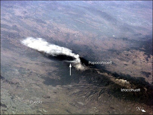
Popo, as it is sometimes called, has been frequently active for six years. On Jan. 23, 2001, the eruption plume reportedly rose to more than 9 km above sea level [for reference, Popo's summit elevation is 5,426 m (17,800 feet)]. Note the smaller ash plume below the main plume (arrow). The perspective from the ISS allowed the astronauts this unique 3-dimensional view.
Ups and Downs
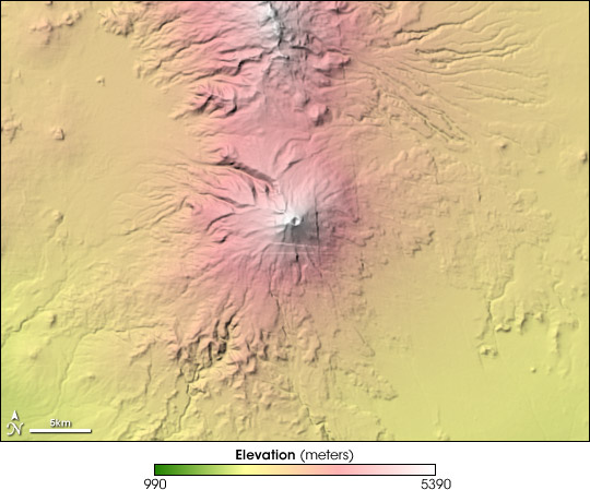
Notice the topography of Popocatépetl and the surrounding landscape in colors ranging from green (low elevation) to yellow to pink to white (highest elevation). The volcano sits in the center of the image, its slopes rising from the surrounding plain. To the east, scallop-edged raised areas show the location of hardened lava flows.
According to the Smithsonian Institution's Global Volcanism website, "At least three previous major cones [at Popocatépetl] were destroyed by gravitational failure during the Pleistocene, producing massive debris-avalanche deposits south of the volcano." That history may explain why the southern portion of the volcano and the terrain to the south appear much more rugged than the area to the west and the east. North of Popocatépetl is a peak known as Iztaccihuatl, a 900,000-year-old volcano whose last eruptive episode was 80,000 years ago. The topographic map is made from data collected by the Space Shuttle Endeavour in February 2000 as part of the Shuttle Radar Topography Mission (SRTM).
Ring of Fire
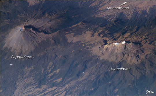
This detailed, oblique astronaut photograph also depicts a neighboring volcano, Iztaccíhuatl (the "Woman in White"). With north to the right in the scene, the view is a westward-looking perspective.
The faint plume emanating from Popocatepetl's 250- to 450-meter-deep summit crater on Feb. 16, 2003, attests to the significant, ever-present hazard the volcano represents to the 25 million people living in the region, including the nearby city of Amecameca, as well as the metropolitan centers of Mexico City to the northwest and Puebla to the east.
Activity Develops
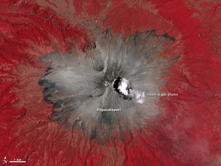
The volcano began emitting a substantial amount of ash on April 12, 2012, and an explosion on April 13 sent volcanic blocks as far as 500 meters (1,640 feet) away from the crater rim. On April 15, an ash plume rose 1.5 kilometers (0.9 miles) above the crater.
When the Advanced Spaceborne Thermal Emission and Reflection Radiometer (ASTER) instrument on NASA's Terra satellite captured this false-color image of the volcano at 12:17 PM local time (17:17 UTC) on April 23, a plume of gas and steam was visible drifting east above the crater. The red depicts forests and vegetation surrounding the volcano.
Sign up for the Live Science daily newsletter now
Get the world’s most fascinating discoveries delivered straight to your inbox.
Restless Beast
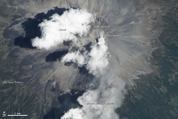
Activity began to intensify in mid-April 2012. The image above, captured by the Advanced Land Imager (ALI) on NASA's Earth Observing-1 (EO-1) satellite, captured this view of Popocatépetl at 11:35 p.m. local time (16:35 UTC) on April 25, 2012.
A plume of steam and ash blows south from the volcano's main vent. The ongoing eruption has flung hot rock fragments onto the northeast flank of the mountain, and a tan patch of what is probably new material called tephra is visible just north of the main vent. Older lava flows are visible cutting into forests on the western slope. A portion of a cloud northwest of the main vent obscures part of the plume.
Captured in Action
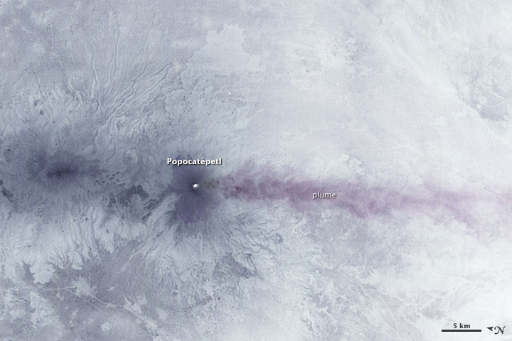
This ghostly image, captured by a NASA satellite, shows the erupting Popocatépetl at night.
[Full Story: Satellite Captures Mexican Volcano's Unceasing Eruption]
Spied from Above
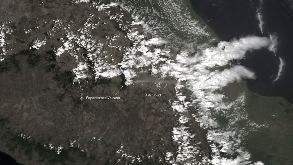
Mexico's Popocatépetl volcano dusted nearby areas with ash this week in one of its largest explosions in recent years. The eruption, combined with a billowing plume of steam and ash and increased seismic activity, has prompted authorities to raise the volcano's alert status and advise people to stay at least 7 miles away from the summit.
[Full Story: Mexico's Erupting Popocatépetl Volcano Spied from Above]

