Earth from Space: Linear Sand Dunes

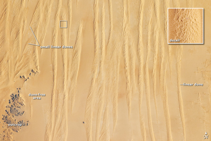
Deep in the Sahara Desert, winds blowing from the north have sculpted the sand into large, linear dunes that run parallel to the winds themselves.
These sand dunes — shown here in the Great Sand Sea of southwest Egypt — are easily spotted from space, as in this image taken by astronauts aboard the International Space Station. Local maps show that these dunes rise 66 to 98 feet (20 to 30 meters) above the surrounding plains, according to a NASA statement.
The distance between the dunes is intriguingly regular at 1 to 1.5 miles (1.5 to 2.5 kilometers), suggesting some equilibrium exists between the wind strength and the sand supply. It is possible that the linear dunes are a reflection of earlier times, when winds were stronger or sand more plentiful.
At first glance, the large linear dunes appear to be the major landform in the image; however, a complex pattern of even smaller dunes can be seen on top of the largest dunes in the inset image. Large sand seas often showcase different dune forms.
The sand in many dune fields usually derives from some larger river not very distant upwind; often it comes from a dry river bed that gets exposed to wind during dry seasons, or from a low-flow river that changed due to a more arid regional climate. West of the dunes shown in this photograph, a large, unnamed river once flowed to the Mediterranean Sea and dumped its sand load 190 miles (300 km) northwest of the area shown. It is likely that this river — evidence of which is now almost completely obliterated — was the source of the sand in the linear dunes.
Get the world’s most fascinating discoveries delivered straight to your inbox.


