Hawaii's Kilauea Volcano Spews Lava, As Seen From Space

Kilauea continues to earn its reputation as one of Earth's most active volcanoes.
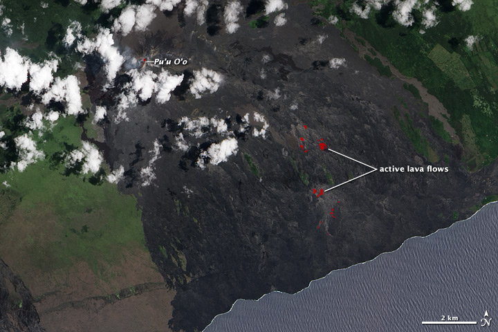
Since January 1983, Kilauea has erupted continuously, coating much of the southeast coast of Hawaii's Big Island in fresh lava, which glows red in this satellite image.
The center of the eruption is Pu'u O'o — a crater southeast of Kilauea's summit. From here, the molten rock flows through lava tubes down Kilauea's steep slopes. The lava emerges on the pali (a Hawaiian word for cliff) and on the coastal plain, further down the mountainside.
The Earth Observing-1 (EO-1) satellite snapped this photo on June 12 with its Advanced Land Imager, which measures infrared light. The red color indicates heat, either from liquid or recently hardened lava still hot enough to glow.
Earlier this month, fresh lava emerged at Pu'u O'o, then traveled through lava tubes downhill. The red hotspots show where molten rock has broken out of tubes near the coast, and the lava lake that fills Pu'u O'o.
Visitors are warned not to approach the lava; according to the U.S. Geological Survey, areas near vents could erupt or collapse without warning. Potentially lethal concentrations of sulfur dioxide gas may also be present within 0.6 miles (1 kilometer) downwind of vent areas like Pu'u O'o.
Kilauea's summit is currently emitting 600 tons per day of sulfur dioxide gas, and spewing small amounts of ash and Pele's hair, small threads of volcanic glass named after Pele, the Hawaiian volcano goddess.
Sign up for the Live Science daily newsletter now
Get the world’s most fascinating discoveries delivered straight to your inbox.
Follow OurAmazingPlanet for the latest in Earth science and exploration news on Twitter @OAPlanet. We're also on Facebook and Google+.


