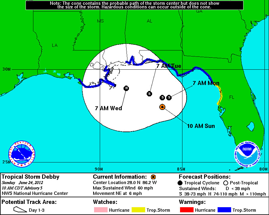
Tropical Storm Debby Forms in Gulf

Tropical Storm Debby, the fourth named storm of the 2012 Atlantic hurricane season, has formed in the Gulf of Mexico.
Debby formed late yesterday afternoon when it was about 220 miles (335 kilometers) south-southeast of the mouth of the Mississippi River. As of this morning, the storm was about 170 miles (270 km) southeast of the same point and 195 miles (315 kilometers) southwest of Apalachicola, Fla.
As of the latest update from the National Hurricane Center, Debby had maximum sustained winds of 60 mph (95 kph), making it a strong tropical storm. Tropical storm-force winds extend about 200 miles (320 km) out from the center of the storm. Most of the thunderstorms generated by the storm are on its north and eastern sides.
Debby could strengthen slightly in the next 48 hours, according to the latest forecast.
The NHC has issued a tropical storm warning from the Mississippi-Alabama border to Ochlockonee River in Florida, which means that tropical storm conditions are expected within that area in the next 36 hours. The northeast portion of the Gulf Coast is already feeling the impact of the storm.
The main impacts from Debby will be storm surge-related flooding, potential tornadoes spawning from the larger storm, and rainfall between 3 and 6 inches (7.6 to 15 centimeters), with potential for isolated amounts up to 10 inches, or 25 cm).
Tropical Storm Debby is currently moving northward and is expected to shift to a westward direction later today or tomorrow, but NHC forecasters have noted that the forecast for the storm is highly uncertain.
Sign up for the Live Science daily newsletter now
Get the world’s most fascinating discoveries delivered straight to your inbox.
Debby follows on the heels of the first hurricane of the 2012 season, Chris, which formed far out in the Atlantic Ocean last week.
The outlook for the 2012 hurricane season indicates it will be a near-normal one, with a total of nine to 15 named storms. So far, four named storms have formed this season. The first two — Alberto and Beryl — formed before the official June 1 start of the season.
Of those storms, between four and eight are likely to become hurricanes — organized, rotating storms with sustained winds of 74 mph (119 kph) or faster.
Between one and three are likely to become major hurricanes, defined as Category 3 storms or above — hurricanes with winds of at least 111 mph (179 mph).
The Atlantic hurricane season ends on Nov. 30.

Andrea Thompson is an associate editor at Scientific American, where she covers sustainability, energy and the environment. Prior to that, she was a senior writer covering climate science at Climate Central and a reporter and editor at Live Science, where she primarily covered Earth science and the environment. She holds a graduate degree in science health and environmental reporting from New York University, as well as a bachelor of science and and masters of science in atmospheric chemistry from the Georgia Institute of Technology.


