Twelve-Foot Waves to Pound Chicago Today
This article was provided by AccuWeather.com.
Bathers, boaters and fishermen beware, as an unusually strong storm system rolls across the Great Lakes region, area waters will get a little rough into the weekend.
Friday may not be the day to take the new boat out or jog along the Lake Michigan Lakeshore as an autumn-style storm affects the region.
The storm system responsible for locally drenching rain and even waterspouts into the weekend will kick up the wind, wave and rip current action in the region.
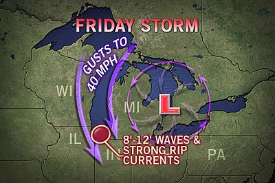
Waters will be especially rough during Thursday evening through Friday on the south end of Lake Michigan. Winterlike wave action is forecast from Milwaukee through Chicago, Gary, Ind., and Benton Harbor, Mich.
RELATED LINKS:
Waves Follow Torrential Downpours
Sign up for the Live Science daily newsletter now
Get the world’s most fascinating discoveries delivered straight to your inbox.
Great Lakes Waterspouts into This Weekend
Stiff northerly winds are likely to produce waves that could be breaking over the shoreline in some areas. Folks who have a daily walk, bike or run along the lake may need to alter their plans.
At peak Friday, waves of 8 to 12 feet are likely over the open waters of Lake Michigan from Rainbow Beach to Indiana Dunes National Lakeshore.
**First thing Friday morning, northeast winds were bringing gusts to near 40 mph along the Lakefront from Milwaukee to Chicago. Winds will gradually become more northerly Friday afternoon and northwesterly Friday night. Waves were averaging 4 to 7 feet, but will increase into the afternoon on the southern end of the lake. Winds and waves will increase on the eastern side of Lake Michigan later in the day.**
During Saturday, waves will begin to ease on the western side of Lake Michigan but will still cause problems on the eastern side.
Meanwhile Saturday, waves will build to 5 to 8 feet along the northern and northeastern end of Lake Erie in response to southwesterly winds.
Rough waters are forecast from Rondeau Provincial Park, Ontario, to Buffalo, N.Y., as a result.
Stiff north to northeasterly winds will drive Lake Huron waters and wave action toward the lower Michigan shoreline Friday into Saturday. At peak Friday evening, waves can reach between 6 and 10 feet from Thunder Bay to Port Hope.
Because of the setup of the storm and the expected wind pattern at the surface and aloft, substantial waves are not expected on Lake Ontario.
Waters can get a little choppy for a time Friday on Lake Superior from Marquette to Whitefish Point with waves of 5 to 7 feet.
Winds and waves will diminish from northwest to southeast across the Great Lakes Sunday.
By the way, if you plan on taking photos of the wild weather over the Great Lakes into the weekend, remember safety first.
© AccuWeather.com. All rights reserved. More from AccuWeather.com.

