Crazy Image: 4 Storms, 2 Oceans
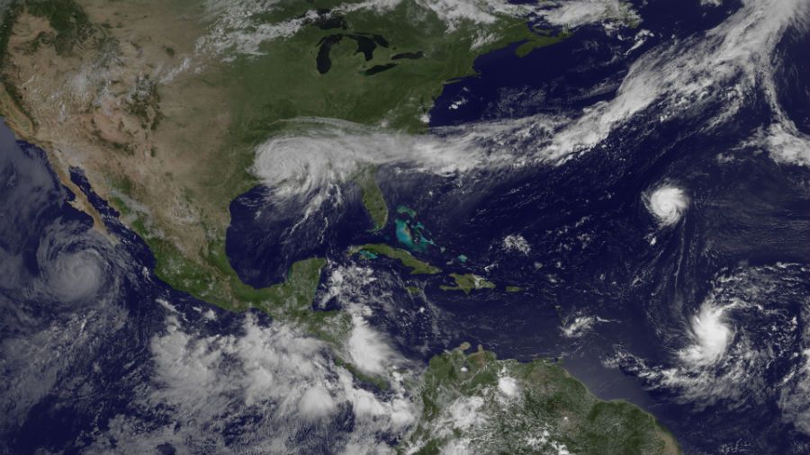
Four tropical cyclones are swirling across the two oceans that sandwich the United States, and a satellite recently captured a portrait of all four storms.
The image, snapped by the GOES East satellite this morning (Aug. 30), shows massive Tropical Storm Isaac hovering over the Gulf Coast. The storm has weakened as it has moved inland, but the slow-moving storm is still causing devastating flooding.
Far out in the middle of the Atlantic is Hurricane Kirk, a dainty storm compared to Isaac. The storm has maximum sustained winds of 75 mph (120 kph) — barely over the 74-mph threshold required for hurricane status. It became a hurricane earlier today.
Hurricane Kirk is about a thousand miles from land, and is expected to veer north ahead of the weekend. Its projected path doesn't put the storm near populated areas, so the fifth hurricane of the 2012 Atlantic season may suffer the same lonely existence as the first: Hurricane Chris spent its entire life far out at sea.
South of Kirk is newly minted Tropical Storm Leslie, a large, but somewhat disorganized storm that has an excellent chance of becoming a hurricane in the next couple of days.
Over in the Pacific Ocean, Hurricane Ileana swirls near the Baja Peninsula. The Category 1 hurricane is packing top sustained winds of 80 mph (130 kph), and is expected to weaken tonight or tomorrow. Ileana is moving away from land, and no coastal watches or warnings are in effect.
Follow OurAmazingPlanet for the latest in Earth science and exploration news on Twitter @OAPlanet. We're also on Facebook & Google+.
Sign up for the Live Science daily newsletter now
Get the world’s most fascinating discoveries delivered straight to your inbox.
