Black Marble Images: Earth at Night

North and South America
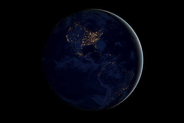
This image of North and South America at night is a composite assembled from data acquired by the Suomi NPP satellite in April and October 2012. The new data was mapped over existing Blue Marble imagery of Earth to provide a realistic view of the planet.Artificial lighting is a excellent remote sensing observable and proxy for human activity, says Chris Elvidge, who leads the Earth Observation Group at NOAA's National Geophysical Data Center. Social scientists and demographers have used night lights to model the spatial distribution of economic activity, of constructed surfaces, and of populations. Planners and environmental groups have used maps of lights to select sites for astronomical observatories and to monitor human development around parks and wildlife refuges. Electric power companies, emergency managers, and news media turn to night lights to observe blackouts.
United States
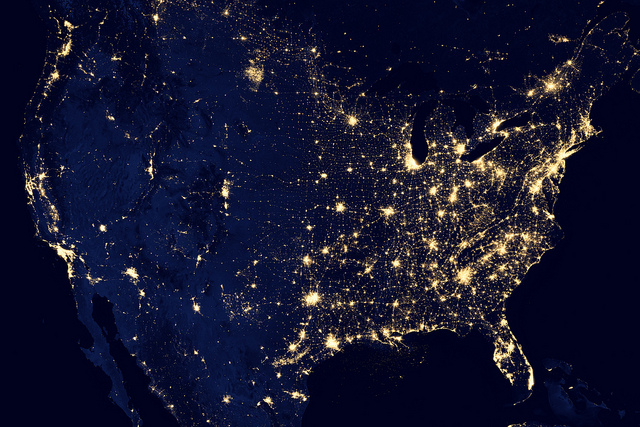
The nighttime view was made possible by the new satellite's day-night band of the Visible Infrared Imaging Radiometer Suite. Nighttime light is the most interesting data that I've had a chance to work with, says Chris Elvidge, who leads the Earth Observation Group at NOAA's National Geophysical Data Center. I'm always amazed at what city light images show us about human activity. His research group has been approached by scientists seeking to model the distribution of carbon dioxide emissions from fossil fuels and to monitor the activity of commercial fishing fleets. Biologists have examined how urban growth has fragmented animal habitat. Elvidge even learned once of a study of dictatorships in various parts of the world and how nighttime lights had a tendency to expand in the dictator's hometown or province.
Africa, Europe and the Middle East
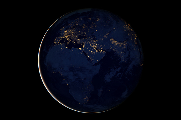
The VIIRS detects light in a range of wavelengths from green to near-infrared and uses filtering techniques to observe dim signals such as gas flares, auroras, wildfires, city lights, and reflected moonlight. In this case, auroras, fires, and other stray light have been removed to emphasize the city lights.Night time imagery provides an intuitively graspable view of our planet, says William Stefanov, senior remote sensing scientist for the International Space Station program office. They provide a fairly straightforward means to map urban versus rural areas, and to show where the major population centers are and where they are not.
Asia and Australia
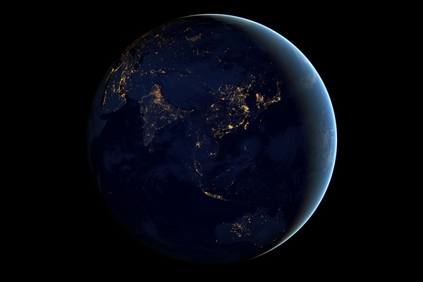
This image of Asia and Australia at night is a composite assembled from data acquired by the Suomi NPP satellite in April and October 2012. The new data was mapped over existing Blue Marble imagery of Earth to provide a realistic view of the planet.Named for satellite meteorology pioneer Verner Suomi, NPP flies over any given point on Earth's surface twice each day at roughly 1:30 a.m. and p.m. The polar-orbiting satellite flies 824 kilometers (512 miles) above the surface, sending its data once per orbit to a ground station in Svalbard, Norway, and continuously to local direct broadcast users distributed around the world.
World City Lights 2012
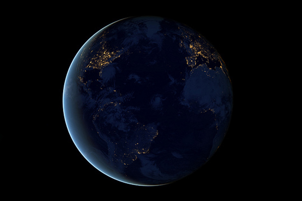
The night side of Earth twinkles with light, and the first thing to stand out is the cities. Nothing tells us more about the spread of humans across the Earth than city lights, asserts Chris Elvidge, a NOAA scientist who has studied them for 20 years.This new global view Earth's city lights is a composite assembled from data acquired by the Suomi National Polar-orbiting Partnership (Suomi NPP) satellite. The data was acquired over nine days in April 2012 and thirteen days in October 2012. It took satellite 312 orbits and 2.5 terabytes of data to get a clear shot of every parcel of Earth's land surface and islands. This new data was then mapped over existing Blue Marble imagery of Earth to provide a realistic view of the planet.
City Lights 2012 - Flat map view
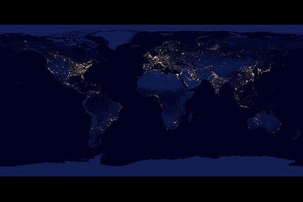
This new image of the Earth at night is a composite assembled from data acquired by the Suomi National Polar-orbiting Partnership (Suomi NPP) satellite. The mission is managed by NASA with operational support from NOAA and its Joint Polar Satellite System, which manages the satellite's ground system.
Auroras in the Antarctic night
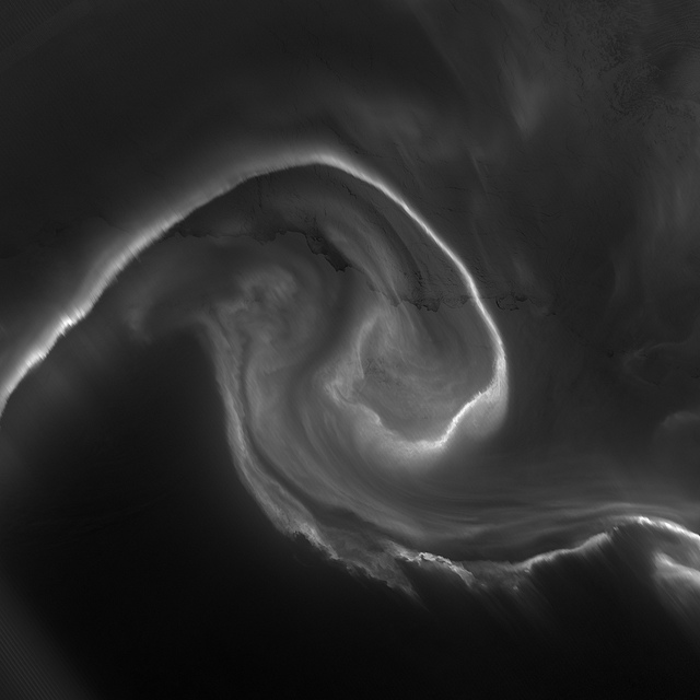
On July 15, 2012, the Visible Infrared Imaging Radiometer Suite (VIIRS) on the Suomi NPP satellite captured this nighttime view of the aurora australis, or southern lights, over Antartica's Queen Maud Land and the Princess Ragnhild Coast.Light from the aurora was bright enough to illuminate the ice edge between the ice shelf and the Southern Ocean. At the time, Antarctica was locked in midwinter darkness and the Moon was a waning crescent that provided little light.
Get the world’s most fascinating discoveries delivered straight to your inbox.
Effects of the Moon - Persian Gulf
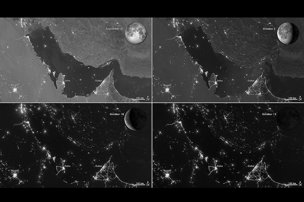
The Visible Infrared Imaging Radiometer Suite (VIIRS) on the Suomi NPP satellite captured these nighttime views of the Persian Gulf region on September 30, October 5, October 10, and October 15, 2012. Each image includes an inset of the Moon in four different phases. September 30 shows the Persian Gulf by the light of the full Moon; October 15 shows the effects of a new Moon. As the amount of moonlight decreases, some land surface features become harder to detect, but the lights from cities and ships become more obvious. Urbanization is most apparent along the northeastern coast of Saudi Arabia, in Qatar, and in the United Arab Emirates (UAE). In Qatar and UAE, major highways can even be discerned by nighttime lights.In eighteenth-century England, a small group of entrepreneurs, inventors and free thinkers James Watt and Charles Darwin's grandfathers among them started a club. They named it the Lunar Society, and the lunaticks scheduled their dinner meetings on evenings of the full Moon. The timing wasn't based on any kind of superstition, it was based on practicality. In the days before electricity, seeing one's way home after dark was far easier by the light of a full Moon. In the early twenty-first century, electricity has banished the need for such careful scheduling, but the light of the full Moon still makes a difference.
The Pond called Texas
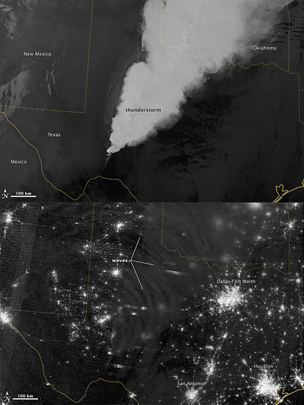
In April 2012, waves in Earth's airglow spread across the nighttime skies of northern Texas like ripples in a pond. In this case, the waves were provoked by a massive thunderstorm.Airglow is a layer of nighttime light emissions caused by chemical reactions high in Earth's atmosphere. A variety of reactions involving oxygen, sodium, ozone and nitrogen result in the production of a very faint amount of light. In fact, it's approximately one billion times fainter than sunlight (~10-11 to 10-9 W
The Nile
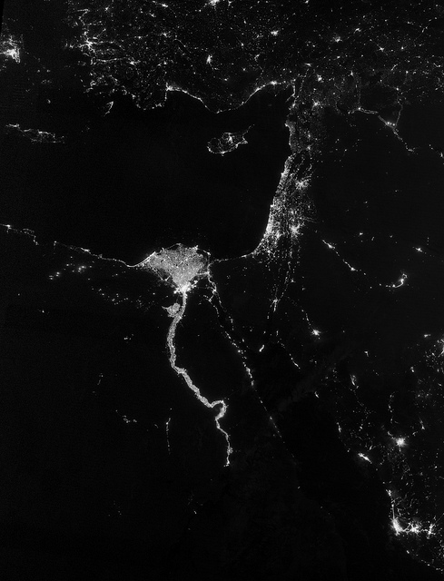
The Nile River Valley and Delta comprise less than 5 percent of Egypt's land area, but provide a home to roughly 97 percent of the country's population. Nothing makes the location of human population clearer than the lights illuminating the valley and delta at night.On October 13, 2012, the Visible Infrared Imaging Radiometer Suite (VIIRS) on the Suomi NPP satellite captured this nighttime view of the Nile River Valley and Delta. The city lights resemble a giant calla lily, just one with a kink in its stem near the city of Luxor. Some of the brightest lights occur around Cairo, but lights are abundant along the length of the river. Bright city lights also occur along the Suez Canal and around Tel Aviv.Away from the lights, however, land and water appear uniformly black. This image was acquired near the time of the new Moon, and little moonlight was available to brighten land and water surfaces.
Polar Darkness at night
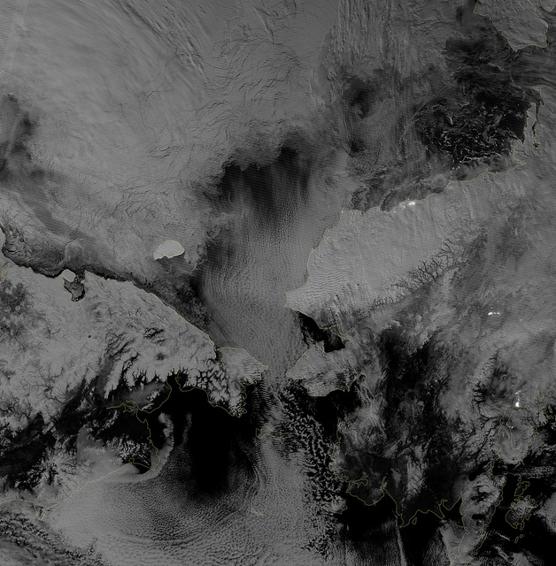
Scientists watched the Arctic with particular interest in the summer of 2012, when Arctic sea ice set a new record low. The behavior of sea ice following such a low extent also interests scientists, but as Arctic sea ice was advancing in the autumn of 2012, so was polar darkness.Fortunately, the Visible Infrared Imaging Radiometer Suite (VIIRS) on the Suomi NPP satellite can see in the dark.The day-night band takes advantage of moonlight, airglow (the atmosphere's self-illumination through chemical reactions), zodiacal light (sunlight scattered by interplanetary dust), and starlight from the Milky Way. By using these dim light sources, the day-night band can detect changes in clouds, snow cover, and sea ice. The VIIRS day-night band offers a unique perspective because once polar night has descended, satellite sensors relying on visible light can no longer produce photo-like images. And although passive microwave sensors can monitor sea ice through the winter, they offer much lower resolution.


