Before and After Images: Grand Canyon Flood
Flooding
In late November, an artificial flood raced through the iconic Grand Canyon, temporarily transforming the clear blue water back to its historic copper color. The first of several planned floods, the Department of the Interior ordered the deluge, released in a gush from the Glen Canyon Dam starting Nov. 19, to rebuild habitat along the Colorado River.
Since the floodwaters retreated, sandy beaches have transformed more than 200 miles (320 kilometers) downstream of Glen Canyon Dam, an early measure of success. The massive floods are designed to help create beaches and back eddies for campers, rafters and native fish.
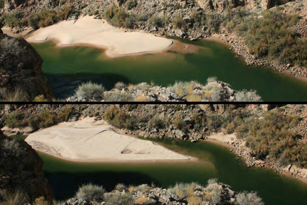
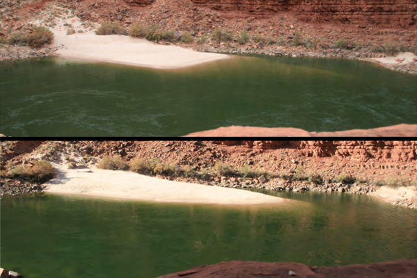
The U.S. Geological Survey recorded the canyon's transformation with remote cameras. The images shown here illustrate the variability of the flood's effects, from adding massive piles of sand to eating away at bushes and rocks.
River mile 22 R
The image on the left was snapped at 4 p.m. on Nov. 17, 2012, from a remote camera in the Grand Canyon along the Colorado River, 22 miles (35 km) below Lee's Ferry.
On the right, is an image shot at 4 p.m. on Nov. 26, 2012, from the same camera. The sandbar present in both images appears bigger after the flood.
The U.S. Geological Survey plans to measure the sand bars each October, as part of the long-term high-flow plan. "We know they all erode over the course of the next year, what we're most interested in is whether the bar in October 2013 is back to exactly the same as it was in October 2012, or if it's smaller or larger," said Paul Grams, a hydrologist with the U.S. Geological Survey's Grand Canyon Monitoring and Research Center in Flagstaff, Ariz. "It's really the long-term monitoring that is our main focus. The photos add in details of what each individual event does."
River mile 33 L
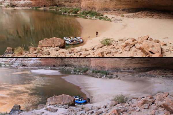
The image on the left was photographed at 4 p.m. on Oct. 5, 2012, from a remote camera in the Grand Canyon along the Colorado River, 33 miles (53 km) below Lee's Ferry. This popular campsite for rafters is called Below Redwall camp.
On the right, an image captured at 9 a.m. on Nov. 29, 2012, from the camera. In it, the campsite appears to have more sand than before the flood.
River mile 41 R
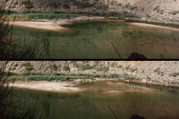
The image on the left was taken at 12 p.m. on Nov. 18, 2012, from a remote camera in the Grand Canyon along the Colorado River, 41 miles (66 km) below Lee's Ferry. The campsite is known as Buck Farm camp.
On the right, an image snapped at 12 p.m. on Nov. 27, 2012.
The flood appears to have deposited sand along the bar during the flood.
River mile 45 L
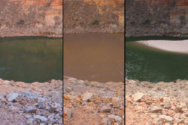
The image on the left was captured at 10 a.m. on Nov. 18, 2012, from a remote camera in the Grand Canyon along the Colorado River, 45 miles (72 km) below Lee's Ferry. The campsite is called Willie Taylor camp.
On the right, an image shot at 10 a.m. on Nov. 28, 2012, from the camera. The beach extends farther into the river than before the flood.
Scientists plan to report initial results in January of whether the six days of high flows realized the Department of the Interior's goals of moving more than 500,000 metric tons of sediment down the canyon.
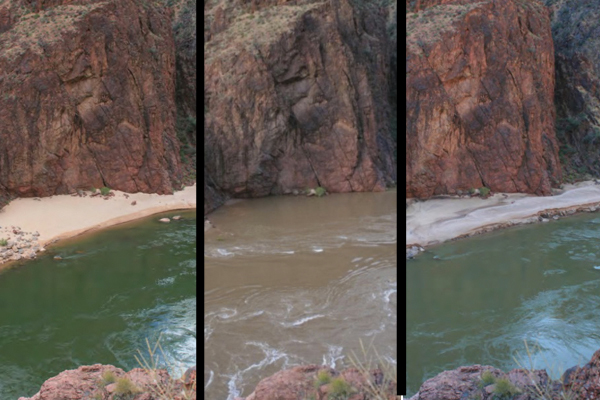
An image of the Colorado River during the flood, captured at 3:56 p.m. on Nov. 22, 2012, is in the middle.
River mile 65 R
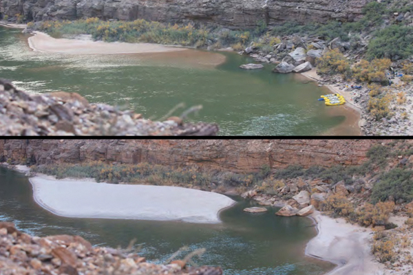
The image on the left was photographed at 4 p.m. on Nov. 17, 2012, from a remote camera in the Grand Canyon along the Colorado River, 65 miles (105 km) below Lee's Ferry.
The high-flow release plan was announced in May by Secretary of the Interior Ken Salazar. Developed after more than 16 years of planning and testing, the strategy allows Grand Canyon flood releases on short notice, without extensive environmental review or planning, through 2020. The order calls for flows from 31,500 to 45,000 cubic feet (892 to 1,274 cubic meters) per second for up to 96 hours in March through April and October through November. Floods during the March through April period are delayed until 2015 to reduce the population of the invasive rainbow trout, which spawn in the spring, and can benefit from the floods.
On the right, an image recorded at 4 p.m. on Nov. 28, 2012, by the camera after the flood. This is Carbon camp, popular with rafters camping on the river. There is more sand at the campsite than before the flood.
River mile 81 L
The image on the left was taken at 1 p.m. on Nov. 17, 2012, from a remote camera in the Grand Canyon along the Colorado River, 81 miles (130 km) below Lee's Ferry. This shot is of Grapevine Camp, upstream from Phantom Ranch, one of the few spots where hikers can cross the river on foot.
On the right, an image snapped at 1 p.m. on Nov. 25, 2012, from the same spot. The flood appears to have removed sand from part of the camp. Such variability is consistent with previous floods, Grams said.
"Some sites respond differently to the same flow," he said. "There will be certain places that tend to build big bars during the high flows, and others tend not to do too much."
An image of the Colorado River during the flood, captured at 7:28 a.m. on Nov. 22, 2012, shows the flood in progress.
Sign up for the Live Science daily newsletter now
Get the world’s most fascinating discoveries delivered straight to your inbox.
River mile 91 L
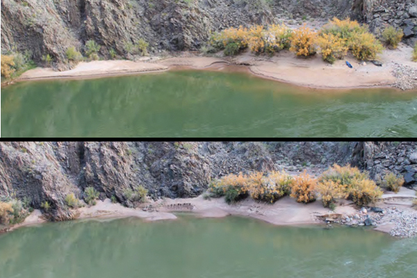
The image on the left was captured at 8 a.m. on Nov. 18, 2012, from a remote camera in the Grand Canyon along the Colorado River, 91 miles (147 km) below Lee's Ferry at Trinity camp.
Since the dam was built in 1966, the only sediment sources for the Grand Canyon are the naturally flowing Little Colorado and Paria rivers, which feed into the Colorado River below the dam. A popular tourist destination, the canyon's beaches and wildlife depend on sand and mud carried by the Colorado River.
On the right, an image shot at 8 a.m. on Nov. 26, 2012, from the same camera. Some rocks appear more exposed than before the flood.
River mile 119.4 R
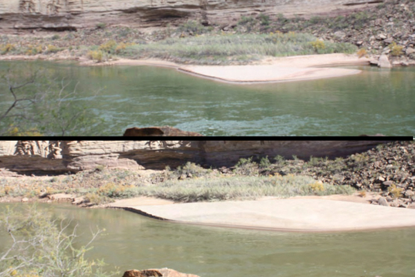
The image on the left was captured at 12 p.m. on Nov. 18, 2012, from a remote camera in the Grand Canyon along the Colorado River, 119 miles (192 km) below Lee's Ferry at Big Dune camp.
On the right, an image snapped at 12 p.m. on Nov. 26, 2012, after the flood. The sandbar appears longer than before the flood.
River mile 194 L
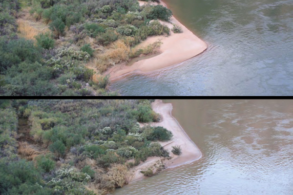
The image on the left was recorded at 8 a.m. on Nov. 17, 2012, from a remote camera in the Grand Canyon along the Colorado River, 194 miles (312 km) below Lee's Ferry at Hualapai Acres.
On the right, an image shot at 8 a.m. on Nov. 27, 2012, from the camera. The flood appears to have reshaped the sandbar, removing some sand.
Follow OurAmazingPlanet on Twitter @OAPlanet. We're also on Facebook and Google+.

