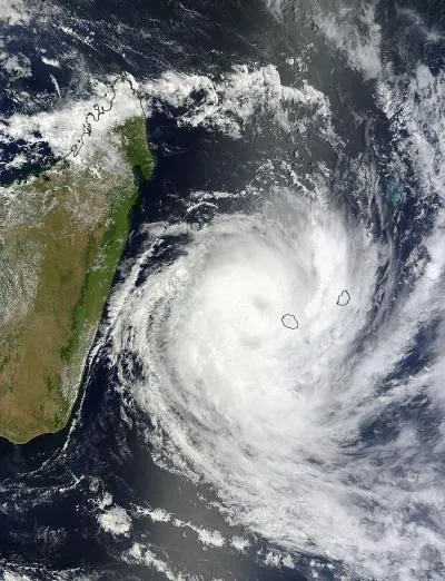
This visible image of Tropical Cyclone Dumile over La Reunion Island and Mauritius was captured by the MODIS instrument aboard NASA's Terra satellite on Jan. 3, 2013, at 0650 UTC. Dumile's center was just northwest of Reunion (left) and Mauritius (right).
(Image credit: NASA Goddard MODIS Rapid Response Team)
Two NASA satellites caught a bird's-eye view of Tropical Cyclone Dumile as it barreled over the Indian Ocean islands of La Reunion and Mauritius on Thursday (Jan. 3).
Dumile first formed as an area of disturbed weather on Dec. 30, 2012, and became a named storm on Jan. 1. The storm is currently a Category 1 cyclone with maximum winds of 80 mph (129 kph) and some wind gusts reaching up to 95 mph (153 kph).
The Moderate Resolution Imaging Spectroradiometer (MODIS) instrument aboard NASA's Terra satellite took a picture of Dumile at 1:50 a.m. EST (0650 UTC) when its center was about 98 miles (157 kilometers) northwest of Reunion Island and Mauritius, according to a NASA release. The strongest thunderstorms within the cyclone's swirling structure appeared to be to the southwest of the storm center, NASA said. Reunion Island and Mauritius lie to the east of the much larger island of Madagascar.
The AIRS instrument aboard NASA's Aqua satellite captured these infrared images of Tropical Cyclone Dumile on Jan. 2 at 2123 UTC, and Jan. 3 at 0936 UTC. The purple areas indicate the coldest, highest clouds with heaviest rainfall. The circular blue area in the middle of the purple area on the Jan. 2 image is Dumile's center.
(Image credit: NASA JPL, Ed Olsen)
The coldest, highest clouds and heaviest rainfall were found in a ring around the storm's center visible in two infrared images taken by the AIRS instrument aboard NASA's Aqua satellite at 4:36 a.m. EST (0936 UTC) on the same day. This infrared imagery also showed that Dumile's central eye had closed off. The collapse of a tropical cyclone's eye typically means the storm is weakening.
Warnings were issued yesterday by the La Reunion-Tropical Cyclone Centre (run by Meteo-France) for La Reunion alerting residents to high winds, heavy rains and rough surf.
The Terra satellite also snapped an infrared picture of the "birth" of Tropical Depression Sonamu off the Philippines yesterday. It is the first tropical depression of 2012 for the western North Pacific Ocean. It currently has maximum sustained winds of about 29 mph (46 kph) and is expected to struggle to intensify as it moves westward over Palawan (an island province of the Philippines) and into the South China Sea, according to a NASA release.
When NASA's Terra satellite passed over Depression Sonamu on Jan. 3 at 9:13 a.m. EST/US the center was approaching southern Palawan.
(Image credit: NASA/NRL)
The latest update for Dumile from the U.S. Joint Typhoon Warning Center has the center of the storm located about 300 miles (480 km) south-southwest of La Reunion and projects that it will move to the southeast and weaken into an extratropical storm. Extratropical cyclones are fueled by the temperature differences in the atmosphere, whereas tropical cyclones are fueled by the energy released during cloud and precipitation formation in warm tropical air.
Sign up for the Live Science daily newsletter now
Get the world’s most fascinating discoveries delivered straight to your inbox.
Tropical cyclones are the same phenomenon as hurricane and typhoons — different names are used in different ocean basins. The southwest Indian Ocean area sees 9.3 storms in a season on average, according to the Hurricane Research Division of the U.S. National Oceanic and Atmospheric Administration. Storm names are set in lists by the World Meteorological Organization and use names found in languages used in the particular region.
Andrea Thompson is an associate editor at Scientific American, where she covers sustainability, energy and the environment. Prior to that, she was a senior writer covering climate science at Climate Central and a reporter and editor at Live Science, where she primarily covered Earth science and the environment. She holds a graduate degree in science health and environmental reporting from New York University, as well as a bachelor of science and and masters of science in atmospheric chemistry from the Georgia Institute of Technology.