Hundreds Forced to Flee After Mississippi River Levee Breach

This article was provided by AccuWeather.com.
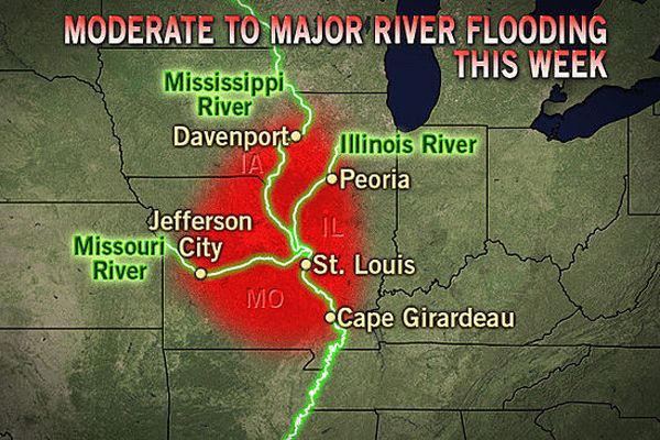
Sirens sounded around 8:30 p.m. CDT on Monday evening in the community of West Alton, Mo., as emergency management officials warned nearly 500 residents to head to higher ground. A breach in the levee protecting the town occurred near U.S. Highway 67 and Lincoln Shields. It only took a matter of minutes before water was inundating areas surrounding the breach.
According to the Saint Louis Post-Dispatch, West Alton officials and Rivers Pointe Fire Chief issued an alert advising residents of the small community to leave immediately following a flash flood warning issued by the National Weather Service.
Dozens of sandbag volunteers were out in full force during the day on Monday in an attempt to reinforce the levee as water began topping it in several places, but by the end of the day, the Mississippi River had risen to over 12 feet above flood stage, proving to be too much for their efforts.
RELATED: More Dangerous Storms From OKC to Kansas City AccuWeather.com Severe Weather Center
Flood gauges at Alton near Mel Price Lock and Dam measured the water level at 34.22 feet as of early Tuesday morning. According to the Advanced Hydrologic Prediction Service, this is classified as "major" flood stage for this station. It is the highest water level measured since 1995, when the river reached 35.10 feet.
According to the National Weather Service, major damage begins in the town of Alton when the river hits 34.0 feet, and this is expected to be compounded by the levee breach as flood waters enter normally protected areas.
Sign up for the Live Science daily newsletter now
Get the world’s most fascinating discoveries delivered straight to your inbox.

The river is expected to remain at major flood stage through at least early Wednesday, and will not subside below flood stage thorough at least the middle of June.
To make matters worse, another round of soaking showers and thunderstorms will move through the area on Wednesday and Thursday. While a repeat of last week's heavy rain is not expected, these showers and thunderstorms could still dump 1-2 inches of rain, and at this point, every drop can make the flooding situation worse as the soil is too moist to absorb anything more.
Much of the Mississippi River basin has been stuck in an exceptionally wet weather pattern over the last 90 days. Some areas around Saint Louis and the Alton area have had nearly double the normal rainfall for the period, which is quite a turnaround from last year when the region was in the grips of a devastating drought.
Current indications are that near-normal rainfall will fall across the area through the middle of June, and this should allow for a gradual fall of water levels along the Mississippi River and surrounding waterways. Even if that is the case, it will still take months, if not years for areas affected by the massive flooding to recover.
AccuWeather.com. All rights reserved. More from AccuWeather.com.
The weather is getting stranger, right? Well, for the most part no, scientists say, but humans often think so when a strange event does occur. So here’s your chance to prove how much you known about weather oddities.
Weird Weather: One Strange Quiz


