JAKARTA, Indonesia (AP) _ Aerial images of tsunami-battered coastlines suggest the world map may be changed forever, with chunks of land sinking into the sea. But did the quake and the killer wave it spawned really significantly reshape the Indian Ocean's outline? Scientists say probably not.
Almost all the apparent land fragmentation is likely due to temporary flooding, experts say. However, there are signs -- still too early to verify -- that a handful of isolated Indian islands near the center of the quake or its aftershocks may indeed have changed.
Cecep Subarya, of Indonesia's National Coordination Agency for Surveys and Mapping, says no new islands have been spotted, and no existing islands have been seen to vanish or split up off the northwest coast of Indonesia's Sumatra island, the earthquake's epicenter.
Nor has Sumatra's coast been reshaped, he said.
Experts say nearly all the rest of the region is too far from the epicenter for the physical geography to have been affected. Those areas look different now because of flooding from the tsunami, but the water will recede.
One exception may be the Andaman and Nicobar islands. Experts say it's possible that the Indian archipelago, some of it about 150 kilometers (90 miles) off northwestern Sumatra and in the general location of strong aftershocks, may have been changed for good.
Local Coast Guard Commander Anil Pokhariyal said his aerial survey of the islands indicated that one may have been cut in two and another divided into three since the disaster. A third island, Sentinelese, appears to be reshaped, he said.
Get the world’s most fascinating discoveries delivered straight to your inbox.
"A long stretch of coral reef, which used to be under the sea, has now emerged overland,'' he said. "The island appears to have tilted -- one side submerged and the other emerging above water.''
However, it is not yet clear whether such reported changes are due to the tsunami, which creates only temporary changes, or to the quake, which can make permanent ones, said Christophe Vigny, a geophysicist at France's National Center for Scientific Research in Paris.
In Sumatra, study results due within the next three weeks will verify whether any apparent changes are the result of temporary floodwater cover or real remolding, Subarya said. If the landscape has been reformed, he said, it is likely to have been only by centimeters (fractions of inches) -- an invisible difference.
He said the entire island had apparently moved a few centimeters closer to India immediately after the quake, but measurements taken Tuesday showed it has mostly moved back in the week since the disaster.
Major immediate landscape changes are more likely to be caused by volcanoes than earthquakes, scientists say. For instance, the 1883 explosive eruption of Indonesia's volcanic Krakatoa island left only one-third of the island above sea level and formed nearby new islands of pumice and ash.
The Dec. 26 tsunami hammered some Indian Ocean coastlines harder than others, and scientists say several factors explain why.
Part of the reason was the wave's shape, Vigny said.
It formed in a north-south line along the quake's fault line, sending the water's full force east toward Thailand and West toward Sri Lanka and India. Bangladesh escaped unscathed because its coast is relatively far north of the epicenter and faces south.
Myanmar has reportedly suffered less than some neighboring countries. However, scientists believe its proximity to Sumatra means it likely took a hard hit, and are skeptical of the ruling military junta's claims of light damage.
"Many scientists think the wave should have hit the southern coast of Myanmar. There is no reason why the wave should not get there,'' Vigny said.
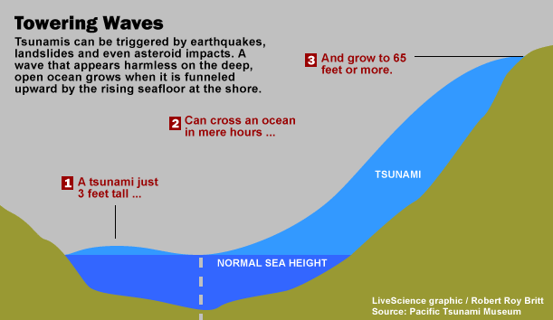
Another reason the tsunami's impact varied in neighboring locations is that, while the wave's height is almost uniform in deep water, its force and behavior are influenced by the shape of the ocean floor when it approaches land. The sea floor shape can either focus or hamper the wave, and since every basin is slightly different, so is every wave.
For example, a steep drop-off from the coastline to the open sea -- rather than a shallow slope -- can form a natural barrier that tames a wave's ferocity.
"Every wave has its own interaction with the coastline,'' Vigny said.
Concerning demographics, experts say they do not expect the heavy death toll, which includes a lot of children, to have any impact on the makeup of populations because younger people are already heavily represented in many affected areas. Also, the total death toll in each country, especially Indonesia, is still a fraction of the population and not enough to make a demographic dent.
Huge Surge
Tsunami Articles
Tsunami-Generating Earthquake Near U.S. Possibly Imminent
The Megatsunami: Possible Modern Threat
Mystery of Deadly 1946 Tsunami Deepens
Earthquake Articles


