2013 in Running for Latest First Atlantic Hurricane on Record
This article was provided by AccuWeather.com.
The 2013 season has a chance at producing no hurricanes through the middle of September, which would rival two records. However, there are some players on the field that could defend those records.
While the 2013 season thus far has delivered six tropical storms, it has not delivered any hurricanes as of Sept. 3.
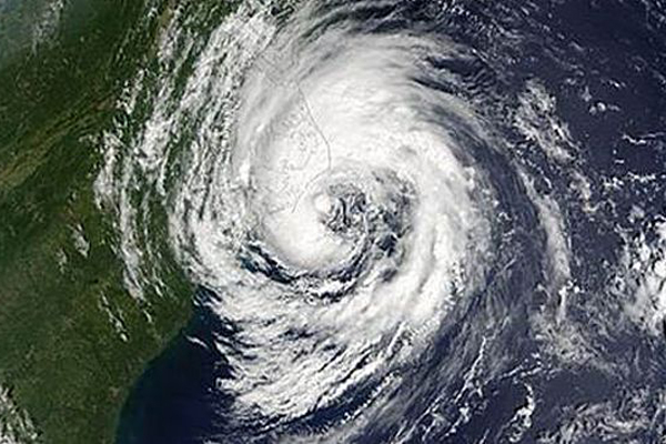
During the satellite era, the latest first hurricane to form on record was Gustav in 2002. Gustav reached hurricane status on Sept. 11 and went on to become a Category 2 storm with maximum sustained winds of 100 mph off the coast of New England and Atlantic Canada, before tracking into Newfoundland. Gustav began as a subtropical system.
This NOAA satellite image shows Gustav brushing the Outer Banks of North Carolina on Sept. 10, 2002.
Prior to satellites, the latest first hurricane on record was during the World War II era. During 1941, the first detected tropical storm formed on Sept. 11. It was not until a second tropical storm strengthened, on Sept. 16, when that season finally had its first hurricane.
Even though that season started so late, there were four hurricanes, including three major hurricanes (sustained winds of 111 mph or greater) with one Category 4 storm with peak sustained winds of 130 mph. Dozens of people were lost at sea during that Caribbean hurricane, which slammed into Central America.
Sign up for the Live Science daily newsletter now
Get the world’s most fascinating discoveries delivered straight to your inbox.
RELATED: AccuWeather.com Hurricane Center Atlantic Hurricane Season Just Getting a Late Start Atlantic Disturbances Currently Impacting the Antilles
According to Hurricane Expert Dan Kottlowski, "Even though dry air has backed off a little in recent days, strong westerly winds aloft continue to interrupt tropical development for almost every budding system."
The atmosphere over the tropics thus far has behaved more like an El Nino pattern, where abnormally warm Pacific Ocean waters create westerly winds aloft over the tropical Atlantic. The current sea surface pattern over the tropical Pacific is considered to be neutral.
"Hurricane formation in the Atlantic is overdue and is soon is likely to shift in favor of multiple tropical systems," according to Kottlowski.
On the tropical weather maps, there are three areas of disturbed weather that could become organized tropical systems now through early next week, but it appears the best chance of a hurricane would not come until the middle of the month.
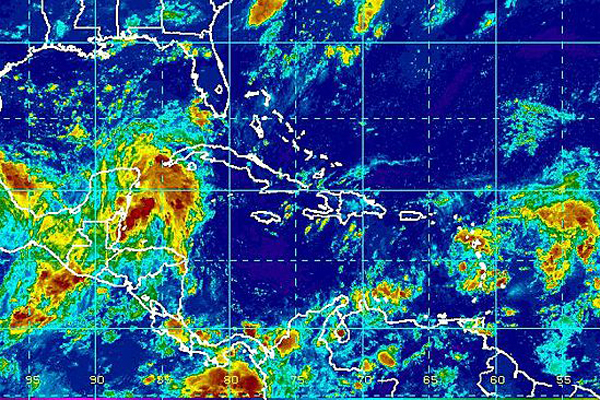
The current weather pattern would prevent a tropical system in the Atlantic from making landfall along the East Coast of the U.S. during the first part of September and would continue to deter rapid strengthening to a hurricane in general during the same period.
According to Expert Senior Meteorologist Brett Anderson, "While there is a window for a Gulf of Mexico system to impact the United States and eastern Mexico, there is currently a buffering zone protecting much of the Atlantic Coast of North America."
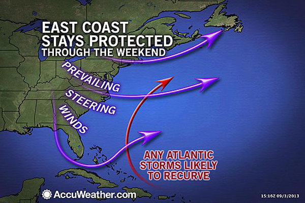
"This zone of strong westerly winds is likely to stay in place into at least the first part of next week," Anderson added.
A system drifting toward the southwestern Gulf of Mexico, near the Yucatan Peninsula as of Sept. 3, is in the most favorable area for quick development.
"The system near the Yucatan Peninsula may not have enough time to develop into a hurricane, before being swept ashore," Kottlowski said.
For those that follow computer models, for the first time this season multiple models are showing significant development of a hurricane over the Atlantic, but not until around Sept. 10 or later.
While such a system could foil the latest first hurricane on record in the Atlantic, steering winds in this part of the basin around the middle of the month would take such a system northward, well away from land over the central part of the basin.
© AccuWeather.com. All rights reserved. More from AccuWeather.com.


