Hurricane Season Jump-Start? Tropical Storm Gabrielle Forms

Update, 11:06 a.m. EDT: Gabrielle has been dowgraded to a tropical depression after a combination of data showed that it had become even more disorganized and wasn't sustaining tropical storm-force winds. It is expected to further degenerate into a remnant low-pressure system, according to the latest update from the NHC.
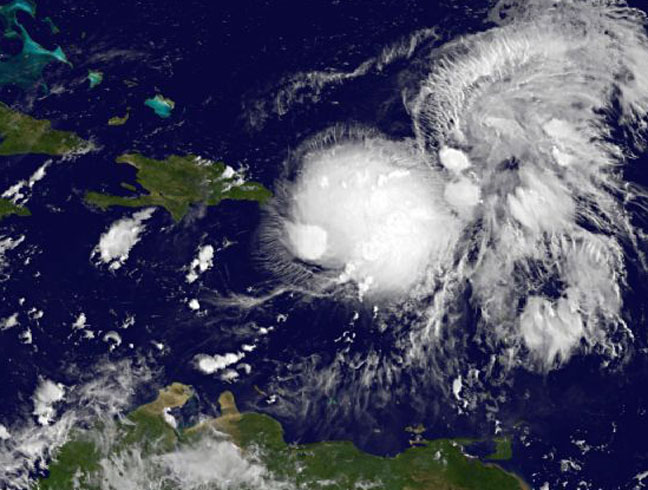
The 2013 Atlantic hurricane season could be revving up after a fairly uneventful August with the formation of Tropical Storm Gabrielle to the south of Puerto Rico and the development of several other storm systems that forecasters are keeping an eye on.
Gabrielle formed from a tropical depression about 70 miles (110 kilometers) south of Puerto Rico late last night (Sept. 4). As of this morning, it was drenching the island with rains expected to measure between 3 and 6 inches (7.6 and 15 centimeters), which could cause flash floods, the U.S. National Hurricane Center warned.
The NHC is also monitoring a low-pressure area over the Gulf of Mexico that it gives a 30 percent chance of developing into a tropical cyclone (a term used for tropical storms, hurricanes and typhoons) in the next few days, before it moves over mainland Mexico. An area to the northwest of Gabrielle is being given a 20 percent chance of developing further, while a spot farther out in the Atlantic has a 10 percent chance.
Gabrielle is a fairly disorganized storm, with maximum winds of 40 mph (65 km/h), and the NHC is forecasting only minimal strengthening in the coming day or two. An Air Force reconnaissance plane will be flying into the storm this morning to get further data on the storm to give forecasters a better picture of the storm's structure and potential for growth. The official forecast doesn't call for the storm to strengthen into a hurricane over the next few days, continuing a season-long drought. [Image Gallery: Hurricane Season 2013]
Gabrielle is the seventh named storm of the season, out of an expected 13 to 19. None of the storms so far this year have developed into hurricanes, thanks to dry air and wind shear, or a change in wind direction with height, over the Atlantic cutting off storm development. (Named storms include tropical storms and hurricanes.) The official NHC forecast anticipated six to nine hurricanes would form, of which three to five would become major hurricanes (those of Category 3 or higher on the Saffir-Simpson strength scale).
The hurricane season in the Atlantic Ocean basin officially starts on June 1, but typically reaches its busiest stretch between late August and early October. But though August was relatively quiet, the season is still on track in terms of tropical storms, NHC spokesman Dennis Feltgen told LiveScience on Aug. 26. In an average year, the fifth named storm of the season shows up on Aug. 31, but Tropical Storm Erin formed on Aug. 15 this year, Feltgen said.
Sign up for the Live Science daily newsletter now
Get the world’s most fascinating discoveries delivered straight to your inbox.
Feltgen cautioned that September could still be a busy month and that more than half of the hurricane season has yet to play out. Hurricanes can be devastating no matter what time of the season they form, as last year's Hurricane Sandy, which formed in late October, proved.
Follow Andrea Thompson @AndreaTOAP, Pinterest and Google+. Follow us @livescience, Facebook & Google+. Original article on LiveScience.

Andrea Thompson is an associate editor at Scientific American, where she covers sustainability, energy and the environment. Prior to that, she was a senior writer covering climate science at Climate Central and a reporter and editor at Live Science, where she primarily covered Earth science and the environment. She holds a graduate degree in science health and environmental reporting from New York University, as well as a bachelor of science and and masters of science in atmospheric chemistry from the Georgia Institute of Technology.


