Hurricane Season 'Peaks' Today — Why No Hurricanes?
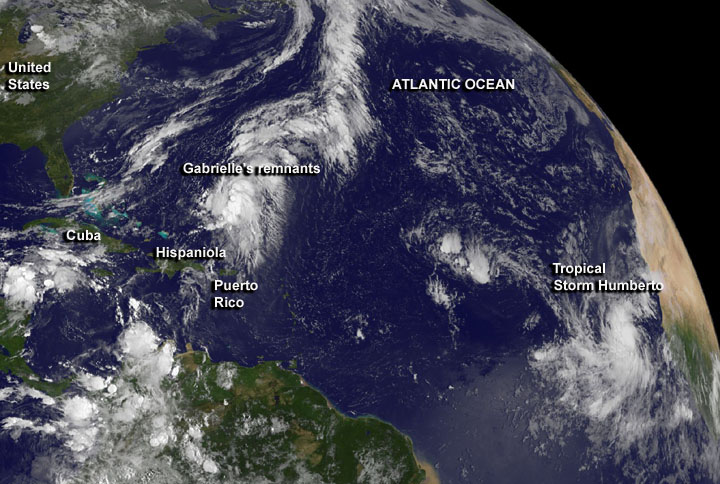
Today (Sept. 10) is the traditional peak of the hurricane season. And yet there haven't been any hurricanes so far this year.
Although Tropical Storm Humberto is churning away in the eastern Atlantic and is expected to strengthen into a hurricane later today, the dearth of hurricanes is somewhat strange in a hurricane season expected to be above average and possibly "extremely active" by government forecasters. And if Humberto doesn't form until tomorrow, 2013 could tie the record for the latest hurricane (set by Hurricane Gustav in 2002), at least within the last 40 years when satellites have allowed for more accurate and comprehensive cyclone monitoring.
In May, researchers from the National Oceanic and Atmospheric Administration (NOAA) predicted that there would be a total of 13 to 20 named storms, a designation that includes tropical storms and hurricanes. They have since reduced the upper limit of their estimate to 19 storms, but still expect an active hurricane season. [Hurricane Season 2013: Storm Coverage]
Humberto aside, why haven't there been any hurricanes yet?
Windy and dry
The unusual lack of hurricanes so far this year can be blamed on westerly winds, said Jeff Weber, a scientist with the University Corporation for Atmospheric Research in Boulder, Colo. So far this summer, there have been strong winds blowing from west to east across the Atlantic, which have systematically destroyed developing storms and prevented them from strengthening and growing into well-organized hurricanes, Weber told LiveScience. Hurricanes are fueled by the transfer of heat from the ocean to the upper atmosphere, but they depend on a relatively symmetrical, rotating system to get going. They form best in calm conditions, with warm surface temperatures and moist air, Weber added. [Image Gallery: Hurricane Season 2013]
Another factor that may be at play is an abundance of unusually dry air in the middle and upper atmosphere, Weber said. Hurricanes are fueled by heat released when water vapor condenses, and do not deal well with dryness, he added. While hurricanes begin as rotating storms at the surface, they need to be able to grow upward to gain strength. "But that dry air suppresses and dampens the ability for that activity to develop and become stronger," he said. This dry air appears to be suppressing cyclone activity all throughout the Northern Hemisphere, he added, although it's not clear why there is more dry air here than usual.
Sign up for the Live Science daily newsletter now
Get the world’s most fascinating discoveries delivered straight to your inbox.
But it should be noted that though there haven't been any hurricanes, it hasn't been an inactive year, said Chris Vaccaro, a NOAA spokesman. There have been eight named storms, more than have usually formed by this point — on average the eighth storm of the season usually takes place on Sep. 24.
And indeed, the surface of the ocean is quite warm — about 2 to 3 degrees Fahrenheit (1 to 1.5 degrees Celsius) above average — conditions that favor hurricane formation, Weber said. Warm oceans are to be expected at this time of year, and indeed, that is why Sept. 10 is the peak of the hurricane season — the sea is at its hottest after slowly heating up all spring and summer, he said.
"The energy is there in the Atlantic Basin; the ocean temperatures are ripe for development," he said. "But so far we haven't had the upper atmospheric conditions to support hurricane formation."
Hurricanes ahead
But that may be changing, and the hurricane drought may be over. It finally looks like the strong westerly winds may be dying down in the near future, and that the hurricane season could ramp up in a big way, Weber said.
The westerly winds in the Altantic basin are driven by warm surface temperatures and convection over the eastern Pacific Ocean. This expanse of convection, a swirling pattern of warm air rising and cold air sinking, looks like it is dying down, meaning winds are likely to calm down. And that should allow more hurricanes to pop up, Weber said.
"I see the possibility for conditions to become favorable within the next 10 days," Weber said. "I won't be surprised to see a couple more thunderstorm systems coming off Africa, and wouldn't be surprised if one or two of them become hurricanes." Hurricanes begin as thunderstorms that gradually grow in strength and achieve a characteristic rotating structure, as long as winds don't tear them apart, he said.
Humberto could usher in a more hurricane-heavy second half of the season when it likely becomes a hurricane later today or tomorrow. There are other indicators that hurricane season is heating up too: Tropical Storm Gabrielle is threatening Bermuda after reforming over the Atlantic, and forecasters are watching a storm system in the Gulf of Mexico for further development.
"It would be a mistake to believe that the second half [of the season] will resemble the first half," Vaccaro said. "The main message of our hurricane season outlook remains unchanged: Be prepared."
Email Douglas Main or follow him on Twitter or Google+. Follow us @livescience, Facebookor Google+. Article originally on LiveScience.

