Super Typhoon Usagi Barrels Toward Taiwan and China

This article was provided by AccuWeather.com.
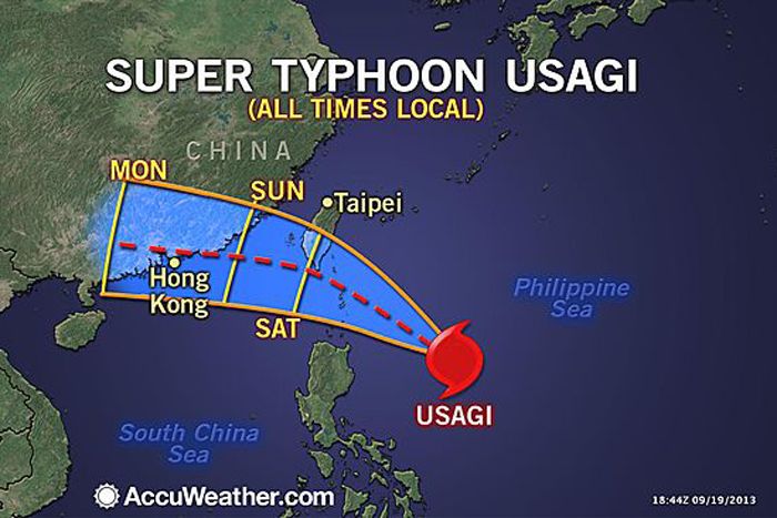
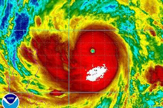
Usagi has strengthened into a super typhoon as it barrels towards Taiwan followed by Southeast China.
Maximum sustained winds of 160 mph were registered with Usagi Thursday night local time (Thursday EDT), increasing its status to super typhoon.
A super typhoon is equivalent to a strong Category 4 or 5 hurricane in the Atlantic with maximum sustained winds of at least 150 mph.
Usagi could strengthen further through Friday as it heads toward southern Taiwan.
The mountainous terrain of Taiwan will slightly weaken Usagi as it approaches the island, but Usagi will still be close to super typhoon status when it reaches or makes its closest approach to far southern Taiwan Saturday morning local time.
Friday afternoon through Friday night, conditions will deteriorate across Taiwan as wind and rain increase and the threat of coastal flooding along the eastern coast heightens.
Sign up for the Live Science daily newsletter now
Get the world’s most fascinating discoveries delivered straight to your inbox.
Wind gusts as high as 140 mph threaten to cause widespread destruction across far southern Taiwan Saturday morning. Such winds will lead to major to severe damage of well-framed homes and snap or uproot many trees. Residents should prepare for lengthy power outages.
Gusts ranging from 90 to 120 mph are expected elsewhere across southern Taiwan. Winds on the higher end of this range are most likely over southeastern Taiwan.
Adding to the concern for loss of lives and property will be a devastating storm surge of 10 to 18 feet along the southeastern coast, while torrential rain also inundates Taiwan.
RELATED: AccuWeather.com Hurricane Center Taiwan Weather Center Hong Kong Weather Center
"Rainfall can easily total a foot in coastal areas on the south and southeast side of the island, and the mountains in the southern half of Taiwan could receive between 20 and 30 inches," stated AccuWeather.com Meteorologist Eric Wanenchak.

That amount of rain is sure to cause life-threatening flooding and mudslides.
The worst of the storm will pass south of Taipei; however, some of Usagi's outer drenching and squally rain bands will spread across the city through Saturday. Wind gusts could occasionally reach 40 mph.
Rain totals will likely be between 2 and 4 inches, heightening concerns for urban flash flooding. Most of that rain will come before Usagi's center reaches far southern Taiwan.
The Philippines will also be spared from the worst of Usagi, but potentially flooding rain and gusty winds will continue to graze northern Luzon Island through Saturday morning.
Flooding will actually become a concern in the capital city of Manila this weekend as Usagi passes to the west of the Philippines and moisture from the typhoon and what was once-Tropical Depression 18W is drawn into the city.
This type of setup during previous tropical systems has led to massive flooding in Manila.
After battering Taiwan, Usagi will take aim at Southeast China with an eventual landfall very close to Hong Kong Sunday afternoon or Sunday night. Usagi could still be a Category 2 or 3 hurricane as it nears Southeast China.
Areas from Zhanjiang to Hong Kong northward to Zhangzhou should closely monitor this storm as the potential for flooding rainfall, damaging winds and coastal flooding exists to close out the weekend.
© AccuWeather.com. All rights reserved. More from AccuWeather.com.
With much of the country experiencing an unseasonably warm winter, fears of climate change come to mind. See how well you understand recent weather, climate and the difference between them.
Pop Quiz: Sign of Climate Change, or Just Weird Weather?


