After Floods, Colorado Scientists Improve Forecasts
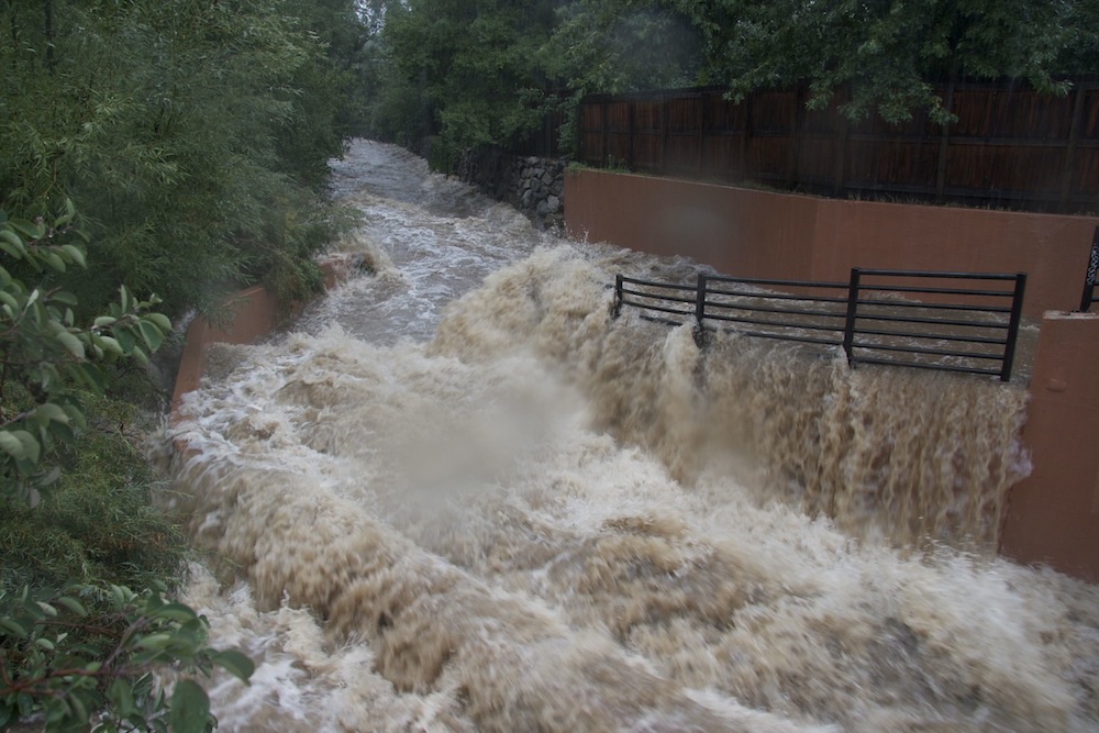
Six weeks after devastating floods swept through the Colorado Front Range, scientists are already working to improve their response for next time.
The effort was slowed slightly by the government shutdown, which put U.S. Geological Survey (USGS), National Oceanic and Atmospheric Administration (NOAA) and some National Weather Service scientists temporarily out of work soon after the flooding. The process of understanding exactly what happened in the Colorado foothills in September will take time: One major data-collection push is scheduled for next summer.
"We've got some challenges in trying to understand why the models weren't able to predict this kind of rainfall event in a very detailed way," said Dave Gochis, who researches hydrology at the National Center for Atmospheric Research's (NCAR) Research Applications Laboratory in Boulder. [Colorado Flood: Photos of a 100-Year Storm]
Checking the forecast
Meteorologists were well aware that northern Colorado was in for a deluge on Sept. 12 and 13. The month is typically a dry one for the region, but two weather systems conspired to park moisture over the area. An upper-level low-pressure system drew moisture from the Southwest, a monsoon pattern common in Colorado in the summer that almost always ends by August but lingered this year. Closer to the ground, upslope winds pulled moisture from the Gulf of Mexico. Researchers at NOAA now say the result was a 1,000-year storm, meaning such an event has only a one-in-a-thousand chance of happening in any given year.
But knowing that rain is coming isn't enough. Meteorologists need to be able to predict when and where the heaviest rain will be. In the Colorado Front Range, the difference of a mile or two could mean the difference between a flash flood in one canyon versus a flash flood in its neighbor.
"They can get the right amount of precipitation but have it in the wrong place, so it's the placement, the timing and the intensity of the rain that are the three factors that are very difficult to get correct," said Barbara Brown, a scientist at NCAR.
Sign up for the Live Science daily newsletter now
Get the world’s most fascinating discoveries delivered straight to your inbox.
Post-storm, the first step is to go back and figure out which weather models predicted the rain most accurately. In the case of the September storms, the rain fell in small, densely packed droplets — a pattern more often seen in the tropics, said Rita Roberts, who is also an NCAR scientist.
"Those estimates that we used that were more tropical in nature did really quite well in estimating the extreme amount of rainfall that fell over the Front Range area, but normally, we would not have been running something like that here," Roberts told LiveScience.
Now, improving the estimates is a matter of going back in the weather models and manipulating the data — moisture levels, cloud physics and more — to see what reflects what really happened.
"Really, it was a mixed bag," said Kelly Mahoney, a researcher at NOAA and the University of Colorado's Cooperative Institute for Research in Environmental Sciences (CIRES). "We need to figure out, of the ones that did well, why did they do well, and of the ones that did poorly, why did they fail."
From rain to flood
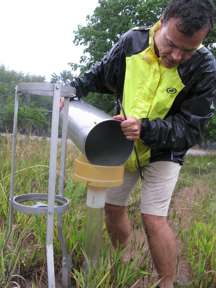
The flooding in Boulder and other Front Range towns was so extreme that many stream gauges were submerged, meaning no one knows how high the water reached in some spots. Rain gauges overflowed or spilled, Matt Kelsch, a hydrometeorologist at the University Corporation for Atmospheric Research (UCAR), said at an NCAR flood seminar on Oct. 4. [See images of an inundated mountain town]
Kelsch and other researchers are reaching out to communities, trying to gather amateur observations to better estimate the water levels on the ground. Scientists are also gearing up for longer-term measurements. USGS researchers will travel to flood sites, looking for high-water marks in order to estimate peak flows.
Next summer, Brown, Roberts and other NCAR scientists will participate in a data-collection drive across the entire Front Range. Dubbed FRONT (Front Range Observational Network Testbed), this project will run during the monsoon season from about July to September. Using radar, automatic rain gauges and other methods, the scientists will track heavy rainfall events throughout the summer, looking for clues that can make their prediction models run better.
"We'll be running these kinds of evaluations all summer and probably into September, I imagine, just seeing how well the newest models perform," Brown said.
During a storm, rainfall estimates are fed into another set of models designed to simulate flooding. That's where NCAR's Gochis comes in. At first, he said, the relationship of heavy rain to flooding is fairly simple. You get a large pulse of water, which runs off the mountains and swells the streams. But as the rain continues, saturating the soil, strange things start to happen. The water finds new paths downstream, cutting new channels and moving through hollow spaces underground.
"The rains just keep coming, albeit not quite as heavy, and we just see stream flow continuing to go up and up and up," Gochis told LiveScience. "A lot of our models don't handle those flow or subsurface processes well."
The impact of recent fires is another complicating factor, he said. In the case of the September flooding, bare areas from recent burns likely caused more runoff in the initial stages of the flooding because there was no vegetation to slow the flow, Gochis said. Soon enough, however, the rains were so prolific that even the healthiest forest wouldn't have prevented flash floods.
Finally, there are human factors. In Boulder, engineering efforts around Boulder Creek lessened the damage that could have been, Gochis said. But irrigation ditches along the Front Range brought water to areas far from rivers and creeks, spreading the flood over a vast area. So far, flooding models don't incorporate these small networks, he said.
"We know that weather science is always going to have a certain amount of uncertainty with it," Gochis said. "But our goal is to constantly narrow that uncertainty, to reduce it and, probably more importantly, to produce the maximum amount of lead time" for evacuations and emergency response.
Follow Stephanie Pappas on Twitter and Google+. Follow us @livescience, Facebook & Google+. Original article on LiveScience.
Stephanie Pappas is a contributing writer for Live Science, covering topics ranging from geoscience to archaeology to the human brain and behavior. She was previously a senior writer for Live Science but is now a freelancer based in Denver, Colorado, and regularly contributes to Scientific American and The Monitor, the monthly magazine of the American Psychological Association. Stephanie received a bachelor's degree in psychology from the University of South Carolina and a graduate certificate in science communication from the University of California, Santa Cruz.
