NASA Maps to Aid Super Typhoon Haiyan Disaster Relief
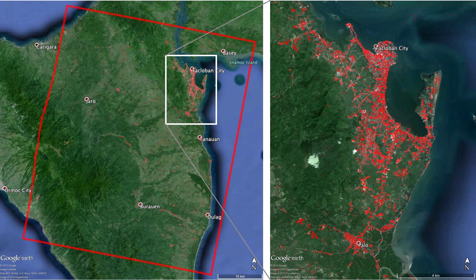
NASA scientists have used satellite images to create detailed maps of the devastation in the Philippines from Super Typhoon Haiyan in order to help disaster relief efforts by recovery crews.
Super Typhoon Haiyan — which struck the island nation on Nov. 8 — was one of the most powerful storms ever recorded, and NASA's Jet Propulsion Laboratory in Pasadena, Calif. produced the damage maps in order to depict the hardest hit regions of the country, NASA officials wrote in a news release.
JPL's ARIA (Advanced Rapid Imaging and Analysis) team created the 24.9 by 31 mile (40 by 50 kilometers) map using data from the Italian Space Agency's COSMO-SkyMed satellite constellation. The image shows the area near Tacloban City, where the storm made landfall. [Photo Gallery: Typhoon Haiyan Hits Philippines]
NASA scientists created the damage map by using "a prototype algorithm to rapidly detect surface changes caused by natural or human-produced damage," space agency officials wrote in a release.
"The assessment technique is most sensitive to destruction of the built environment," NASA officials wrote in a statement. "When the radar images areas with little to no destruction, its image pixels are transparent. Increased opacity of the radar image pixels reflects damage, with areas in red reflecting the heaviest damage to cities and towns in the storm's path."
The scientists used data gathered from Aug. 19 to Nov. 11 to calculate the change.
Haiyan's storm surge reached up to 20 feet (6 m) in parts of the Philippines, and some estimates place the death toll at 2,000. Before it made landfall, the super typhoon had sustained winds of up to 190 mph (305 km/h). The typhoon's strength was equivalent to a strong Category 5 hurricane, tropical weather expert Brian McNoldy told LiveScience.
Sign up for the Live Science daily newsletter now
Get the world’s most fascinating discoveries delivered straight to your inbox.
This is not the first time NASA has released a map of a country post-natural disaster. In 2011, the space agency put out multiple images of Japan after the country was hit by a devastating earthquake and tsunami.
Italy's COSMO-SkyMed satellite also imaged the Myanmar cyclone and Chinese earthquake in 2008, aiding in the relief effort for those two countries.
ARIA is currently a program in development. The system is designed to use images taken from space to quickly assess the impact of a disaster on a region, NASA officials said. The ARIA team plans to build "an automated system for providing rapid and reliable GPS and satellite data to support the local, national, and international hazard monitoring and response communities," NASA officials said.
Follow Miriam Kramer @mirikramer and Google+. Follow us @Spacedotcom, Facebookand Google+. Original article on SPACE.com.

