GPS Helped Forecast 2012 Earthquake


Scientists were watching closely as a subduction zone along Costa Rica built to its breaking point in 2012.
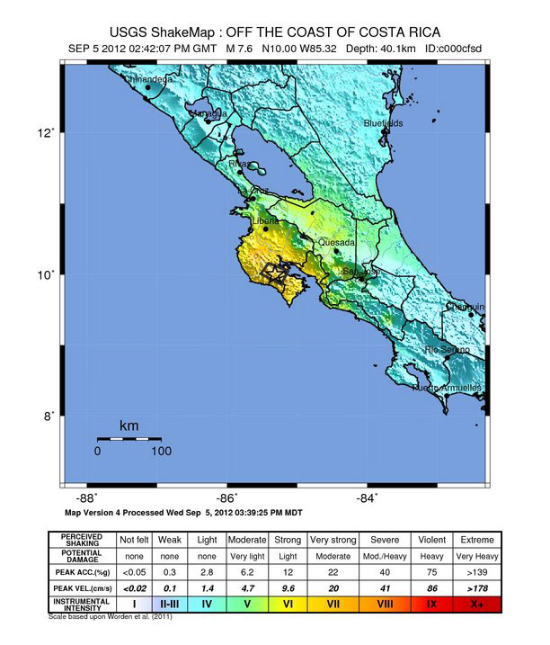
When a magnitude-7.6 earthquake finally ripped open the offshore fault on Sept. 5, 2012, cracking buildings and collapsing a bridge, it was one of the first successful quake forecasts using GPS monitoring. (A forecast is a probability that an earthquake of a specific size will strike a specific location, and sometimes offers a time window. A prediction, on the other hand, says the quake will or will not occur during a specific time. It's like the difference between saying there's a 50 percent chance of rain on Monday and your house will be rained on Monday morning.)
"We're not predicting an earthquake," said Andrew Newman, a geophysicist at Georgia Tech. "The timing is something we still don't have a good handle on. But we can say where, and how big," Newman told LiveScience's OurAmazingPlanet.
Watching, waiting
Just a few months before the Costa Rica earthquake struck, an international team of scientists led by researchers in Costa Rica and the United States had forecast the size — a magnitude-7.8 — and location of the temblor. Their estimate was based on years of GPS measurements, which tracked subtle earth movements along the fault. Now, in a postquake analysis, the team has graded its forecasting performance. The results were published Dec. 22 in the journal Nature Geoscience.
"We now have the ability to very clearly identify reas that are locked up and building up energy for large earthquakes," said Newman, a study co-author.
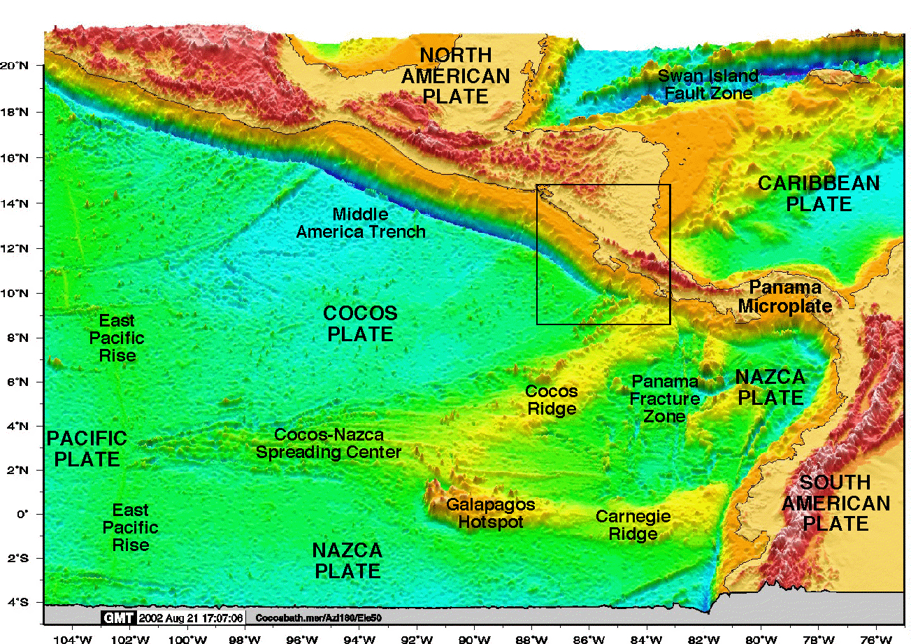
The earthquake was centered about 25 miles (40 kilometers) below the Nicoya Peninsula, where million-dollar resorts draw ecotourists. Though buildings were damaged, no one was killed, in part due to the country's earthquake-conscious building codes. This gorgeous coastline also offers a unique dry lab for studying the shallow part of subduction zone earthquakes. (A subduction zone is the collision of two of Earth's tectonic plates. At the subduction zone, one plate dives deep into the Earth, bending beneath the other.) [Infographic: Tallest Mountain to Deepest Ocean Trench]
Get the world’s most fascinating discoveries delivered straight to your inbox.
The thumb-like Nicoya Peninsula juts into the ocean, providing a platform for monitoring the shifting earth. At most subduction zones, miles of ocean lie between the shallow part of these faults and curious scientists. Geoscientists are interested in the shallow zone because this is where tsunamis are triggered. In Japan's 2011 Tohoku earthquake, the fault appeared to break all the way to the surface, surprising scientists — no subduction zone had cracked like this before. Big earthquakes in Sumatra and Costa Rica stopped deeper in the Earth.
"This is a really unique observatory for observing subduction zone environments," Newman said. "At this point, we still don't have a really good understanding of why the shallow zone locks or not."
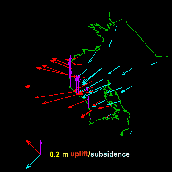
With GPS and surveying by scientists, the team tracked where the Nicoya Peninsula bulged upward or sank downward — uplift or subsidence, in geology parlance. These surface changes revealed what has happening underground on the fault. The researchers were looking for zones where the fault locked, or stuck together.
"Just before the earthquake, there were places where the coconut groves [along the coast] were starting to be eroded away because relative sea level was getting higher and higher," Newman said. In those places, strain was building up in locked patches on the fault and pulling down the land, he said.
The where, not the when
Newman and his colleagues published a model of the subduction zone on June 26, 2012, in the Journal of Geophysical Research, that forecast the size of the next Nicoya Peninsula earthquake and where it would strike. The most dangerous spots along the subduction zone, according to their research, were two locked patches — where the fault sticks and stores energy for a future quake — one offshore and one under the peninsula.
The historic earthquake record in Costa Rica also boosted the group's forecast accuracy. Three earthquakes larger than magnitude-7.5 struck the Nicoya Peninsula in the last 160 years, in 1853, 1900 and 1950. In 1989, the U.S. Geological Survey forecast a 93 percent probability of a large earthquake there before 2009.
It turns out that the Sept. 5 earthquake was a little smaller than expected, but the temblor did rip open the stuck zone beneath the peninsula, Newman and his colleagues report in the new Nature Geoscience study. And while the offshore locked zone initially looked like it was still stuck after the quake, it's now releasing stored energy through aseismic slip, or movement without notable earthquakes, Newman said.
Watching Costa Rica's subduction zone build up strain between earthquakes (similar to a compressed spring) helped geoscientists forecast the Nicoya earthquake. Similar studies could track other treacherous subduction zones, but monitoring the ocean floor costs hundreds of thousands of dollars, Newman said. Along Costa Rica's Pacific coastline, researchers can avoid that expense by installing GPS stations on land.
"With the proper tools, we can actually map out the interface where large earthquakes are building up energy," Newman said. "This environment made it very easy, but we don't need to have rapid recurrence or land as a requirement. We could do this in any subduction zone, including Cascadia [off the Pacific Northwest] and Alaska. What we really need to do as a community is figure out a way to do it cheaper."
Email Becky Oskin or follow her @beckyoskin. Follow us OurAmazingPlanet @OAPlanet, Facebook and Google+. Original article at LiveScience's OurAmazingPlanet.


