New Website Tracks Deforestation in Near Real-Time
Forests around the world are disappearing at an astonishing rate. But now, these trees won't fall without a sound.
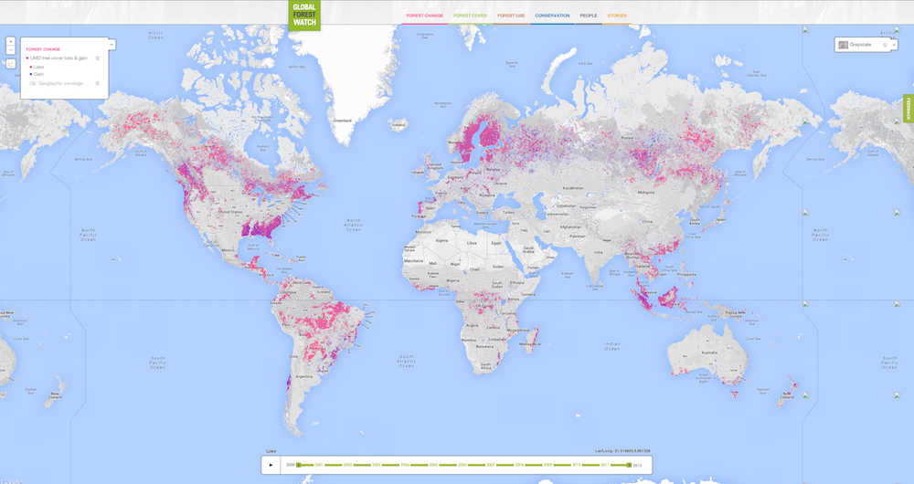
A new map and website called Global Forest Watch provides the first near-real-time look at the planet's forests, using a combination of satellite data and user-generated reports. The website's developers hope that Global Forest Watch will help local governments and companies combat deforestation and save protected areas.
"More than half a billion people depend on [forests] for their jobs, their food, their clean water," said Andrew Steer, the CEO of the World Resources Institute (WRI), which launched the website today (Feb. 20). "More than half of all terrestrial biodiversity lives in forests."
But humans are failing to preserve these crucial ecosystems, Steer told reporters before the launch. The equivalent of 50 soccer fields each minute have fallen every day of the past 13 years. [See Images of the New Deforestation Map]
Monitoring forests
Until now, there has been no good way to keep track of this rapid forest loss, leaving governments and organizations struggling to provide solutions. One example is the food company Nestlé, which committed to a zero-deforestation policy in 2010. The company pledged not to buy supplies such as palm oil from companies that clear-cut forested areas. Trying to trace these ingredients to their source proved incredibly difficult, said Duncan Pollard, the company's head of stakeholder engagement in sustainability. The company tried to do the research itself and ended up with reports full of rudimentary maps more than five years out of date.
The new Global Forest Watch will update monthly at a medium resolution with data from NASA's Moderate Resolution Imaging Spectroradiometer (MODIS) on the Terra and Aqua satellites. The resolution of these monthly updates is somewhat coarse, but every year, the map updates with much finer-grained imagery from NASA's Landsat program. Each pixel of Landsat data is roughly equivalent to a baseball infield, said Nigel Sizer, the director of the WRI Global Forest Initiative. That's 100 times finer than the monthly updates, according to Sizer.
Sign up for the Live Science daily newsletter now
Get the world’s most fascinating discoveries delivered straight to your inbox.
"What is new here is that we are taking an enormous amount of very complex and very confusing information and making it available to everyone, everywhere," Sizer said. [Video: Monitoring Forests in Near Real-Time]
Mapping deforestation
The fine-grained map comes from the work of Matt Hansen, a geographer at the University of Maryland, and his colleagues, who published the first Landsat map of global deforestation last year. The WRI and about 40 other partners, including Google, then got on board to turn Hansen's map into something interactive and public.
At globalforestwatch.org, users can scroll across the globe and zoom in on areas of loss (and, more rarely, gain). Users of Google Maps will find the format very familiar, given that the company was a major partner in creating the website.
"If you can find a friend's address, you can easily use this map," Sizer said.
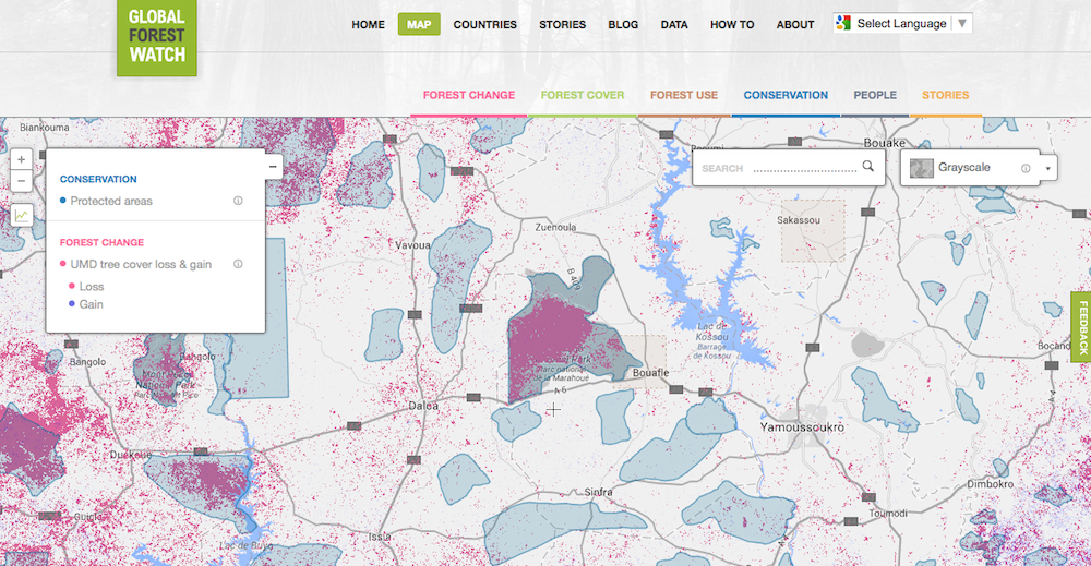
The map reveals sobering data, including supposedly protected areas that are nearly destroyed. Marahoué National Park in Côte d'Ivoire in Africa shows up completely pink on the map view — it has lost more than 90 percent of its trees despite its national park status.
Users can draw on the map and receive updates about the outlined region; in some areas, the map includes land use. In Indonesia, users can see which palm oil companies are operating in which areas. Before Global Forest Watch, no one had access to that information, Sizer said.
The site also has a section for stories, which allows users to submit news about areas that have been clear-cut or that are threatened.
The goal is to continue improving Global Forest Watch with more frequent data updates and algorithms that can differentiate between native forests and plantations.
"We now have the possibility of doing something that would have been absolutely unheard of 10 years ago," Steer said, "which is near real-time data delivered to everybody who has a laptop, or a computer, or a smartphone in the world."
Follow Stephanie Pappas on Twitter and Google+. Follow us @livescience, Facebook & Google+. Original article on Live Science.

Stephanie Pappas is a contributing writer for Live Science, covering topics ranging from geoscience to archaeology to the human brain and behavior. She was previously a senior writer for Live Science but is now a freelancer based in Denver, Colorado, and regularly contributes to Scientific American and The Monitor, the monthly magazine of the American Psychological Association. Stephanie received a bachelor's degree in psychology from the University of South Carolina and a graduate certificate in science communication from the University of California, Santa Cruz.

