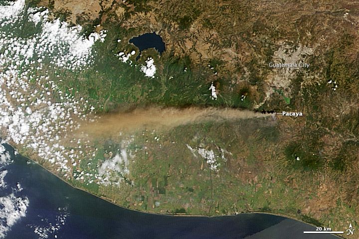
Seen from Space: Guatemala's Pacaya Volcano Pops

A bevy of satellites have caught a bird's-eye view of Guatemala's Pacaya volcano since the peak popped its top on March 2. Pacaya watchers have posted images of ash plumes and glowing lava on their blogs, all from the watchful sensors of four NASA satellites, including Landsat 7 and Landsat 8, Terra and Aqua.
Pacaya volcano is close to the capital, Guatemala City, and just 24 miles (38 kilometers) from resort towns such as Antigua. The 8,373-foot-tall peak (2,552 meters) is one of Guatemala's most active volcanoes and has been belching on and off since January. An explosion on Monday (March 3) opened a new lava vent between the volcano's Cerro Chino and Mackenney crater, according to CONRED, the national hazard-monitoring agency.
On Sunday, Pacaya spewed ash 13,000 feet (4,000 m) into the sky, prompting some flight cancellations, though the ash is moving away from the capital and resorts. The volcano is at yellow alert and no evacuations have been ordered, according to CONRED. Volcanic activity at Pacaya is currently waning, according to the national geological agency, INSIVUMEH.
Pacaya is one of three volcanoes now steaming in Guatemala, joining Fuego and Santiaguito, both of which are generating lava flows. The country is home to 22 volcanoes. Guatemala is located above one of Earth's subduction zones, where a crustal tectonic plate bends underneath another plate. Fluids boiled out of the sinking plate melt the rock above it, creating rising magma plumes that form volcanoes.
Email Becky Oskin or follow her @beckyoskin. Follow us @OAPlanet, Facebook and Google+. Original article at Live Science's Our Amazing Planet.
Sign up for the Live Science daily newsletter now
Get the world’s most fascinating discoveries delivered straight to your inbox.


