The international date line, explained
The international date line is an imaginary line that runs north-south across the Pacific Ocean from the North Pole to the South Pole.

The international date line (IDL) is an imaginary line that runs along the Earth's surface from the North Pole to the South Pole in the middle of the Pacific Ocean. When you cross it, you either gain or lose a day depending on which way you are traveling. If you are traveling westward, you gain a day, and if you are traveling eastward, you lose a day.
For example, if a traveler moves eastward across the Pacific Ocean from Wake Island to the Hawaiian Islands on June 25, they will jump backward to June 24 as soon as they cross the IDL. If, however, they are traveling in the opposite direction, they will arrive at Wake Island on June 26.
Although the traveler seems to move backward or forward in time, there's no physics-defying magic going on here. The international date line is based on a rational, practical system of universal timekeeping that takes into account the movement of Earth around the sun.
Related: How can Samoa hop over the international date line?
Why do we need the international date line?
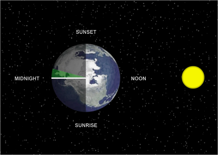
Earth rotates counterclockwise (from west to east) on its axis as it travels around the sun. This means that different parts of the planet receive the sun's direct rays at different times, so when it is noon on one part of Earth — the period when the sun is at its highest in the sky — another part of the planet may be completely in shadow or experiencing sunrise or sunset. It also means that, theoretically at least, if you were somehow able to outrun Earth's rotation, which is a speed of roughly 1,000 mph (1,600 km/h), you could experience perpetual daylight and never see darkness.
But humans don't travel at such speeds (unless you are on the International Space Station), and when not traveling people generally stay in one place. So, to allow people to experience daylight hours in roughly the same amount — that is, to experience a normal day from sunrise to sunset — time zones are in use around the world.
The first system of time zones was proposed by Sir Sandford Fleming in 1876, according to an article in Globe and Mail, a Canadian news publication. Fleming was a Scottish engineer who helped design the Canadian railway system. He wanted to make the railroad more efficient and avoid any complications resulting from the different schedules set by the different train stations, which set the time according to their local astronomical conditions, according to Encyclopedia Britannica. Accordingly, he proposed a system of 24 standard time zones that would span the circumference of the Earth. Within each time zone, all clocks would be set to an average time that best represented where the sun was located in the sky. The practicality of his system soon caught on, so that by 1900 most of the industrialized nations of the world had adopted it.

Today, with a number of significant modifications, we still use the 24-time-zone system originally proposed by Fleming. The logic of dividing Earth into 24 zones is derived from the fact that the planet is a sphere, and like any sphere it can be divided into 360 equal sections, or 360 degrees. Each time zone is measured as 15 degrees wide, and 360 divided by 15 is 24.
All of these zones are numbered consecutively eastward from what is called the prime meridian, which is a line of longitude that runs directly through the British Royal Observatory in Greenwich, in the United Kingdom. The prime meridian was established in 1851 at a time when the U.K. was one of the most powerful and technologically advanced nations on Earth. With a powerful navy, the British were well advanced in navigation and timekeeping and were using the most sophisticated devices available to reckon global position and time. The prime meridian, at 0 degrees longitude, is the point from which all other measurements of longitude are taken. The prime meridian is also where the system of 24-hour timekeeping that is called Greenwich Mean Time (GMT) originated.
As you go east from the prime meridian, the time zones increase consecutively by one hour, or conversely, decrease consecutively by one hour as you go west. But Earth, of course, does not go on indefinitely; eventually, a point is reached when you have to start over — or jump backward or forward in time depending on your direction of travel.
What happens when you cross the international date line?
Here's an example of how time zones and the international date line works.
London, U.K. is eight time zones away from San Francisco, California. Going eastward from San Francisco to London, you move ahead eight time zones, which really means you skip forward eight hours. So, when the time in San Francisco is 1 p.m, the time in London is 9:00 p.m. on the same day.
However, if you were to move eight time zones in the opposite direction from San Francisco at 1 p.m. — that is, west across the Pacific Ocean to the Siberian city of Yakutsk, for example, things get complicated. It's not simply a matter of subtracting eight hours from the San Francisco time. You start by subtracting an hour for each time zone moving west, making it to 9:00 a.m., but at that point you'll hit the IDL, where everything changes. Now you have to add a full 24 hours to your calculations and jump a full day ahead, making it 9 a.m. the next day.
But you're not done yet. Because all the time calculations are taken from Greenwich, you must subtract four more hours from that time because Yakutsk sits four time zones west of the IDL. So, when the time in San Francisco is 1:00 p.m. on Wednesday, it is 5:00 a.m. on Thursday in Yakutsk.

How the IDL began
The IDL was established in 1884 during the International Meridian Conference held in Washington, D.C., according to Post Card History. President Chester A. Arthur convened the conference, which included representatives of 26 nations. The president, like other world leaders, saw the necessity of establishing standards for an international agreement on time and longitude. By the end of the 19th century, as global commerce progressed, communication technologies grew more sophisticated and nations grew increasingly interdependent, it was imperative that all clocks be set to a world standard.
With this in mind, the point of the conference, as summed up in the Protocols of the Proceedings, was "for the purpose of fixing upon a meridian proper to be employed as a common zero of longitude and standard of time-reckoning throughout the globe."
The conference resulted in the recognition of the prime meridian in Greenwich, which had already been in use for several decades, as the world's single "initial meridian." Although other prime meridians were in existence at the time, such as ones in Rome, Paris, Jerusalem, St. Petersburg and Oslo, for example, the Greenwich meridian was adopted primarily because over two-thirds of ships already used it for zero longitude.
In all, seven resolutions were passed at the end of the conference. These ranged from adopting a universal solar day (beginning at midnight in Greenwich and counted on a 24-hour clock) to the proposal that all nautical and astronomical days everywhere would begin at 12:00 a.m.
The IDL was established as a result of the conference's Third Resolution, which stated: "That from this meridian longitude shall be counted in two directions up to 180 degrees, east longitude being plus and west longitude minus."
The logic behind this is that on a discrete sphere, the day and date have to be separated at two locations — you can't split a sphere into two parts with a single "cut" on one side. You need a starting and an ending point.
None of the resolutions, however, were binding. It was up to each country to enforce these proposals. Even today, for example, the IDL is not a matter of international law, nor is it enforced by the dictates of an international governing board. It is accepted by all nations and has been adopted because it is crucial for global interconnectivity, instantaneous communication, time measurement and consistent international databases.
Why is the international date line not straight?
An excellent way of visualizing the IDL is to think of it in terms similar to a line of longitude. In fact, it roughly follows the 180-degree meridian, which is located halfway round the world from the prime meridian. But the IDL, unlike a meridian line, does not run in a straight path. Since its inception, the IDL has undergone several major deviations, and it now swerves, zig-zags and jogs in a seemingly arbitrary pattern around prominent landmasses and certain Pacific islands. Most of these deviations are the result of practical considerations, such as to avoid splitting a country into two time zones, or for political and economic reasons.
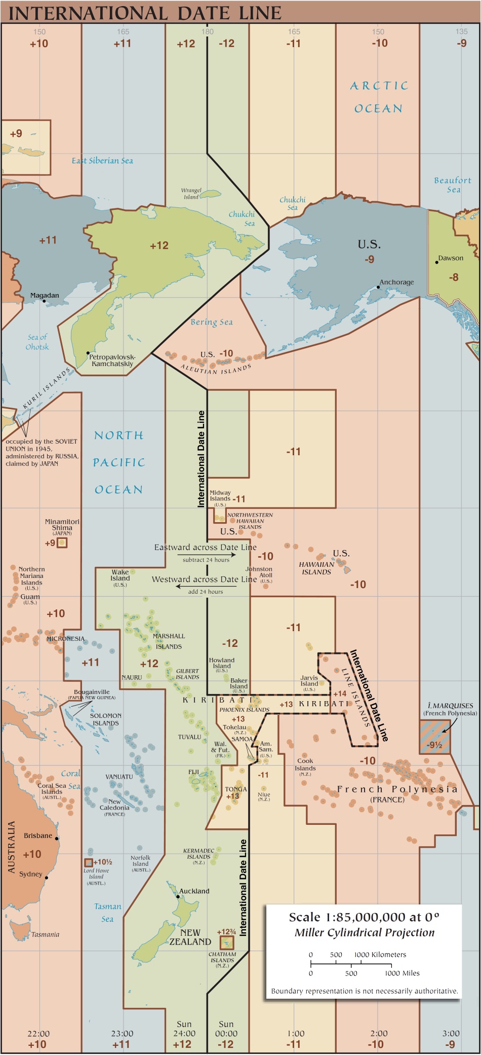
The IDL runs south from the North Pole, following the 180-degree meridian until it swerves east to pass through the Bering Strait, keeping Big Diomede Island, a part of Russia, west of the IDL, and Little Diomede Island, which is part of the United States, to the east. Although the islands are only separated by the narrowest of margins — just 2 miles (3.2 kilometers) — they experience different days, with Big Diomede Island always one day ahead of Little Diomede Island. The IDL then jogs back west to skirt around the United States’ Aleutian Islands, keeping Russia and Alaska on opposite sides.

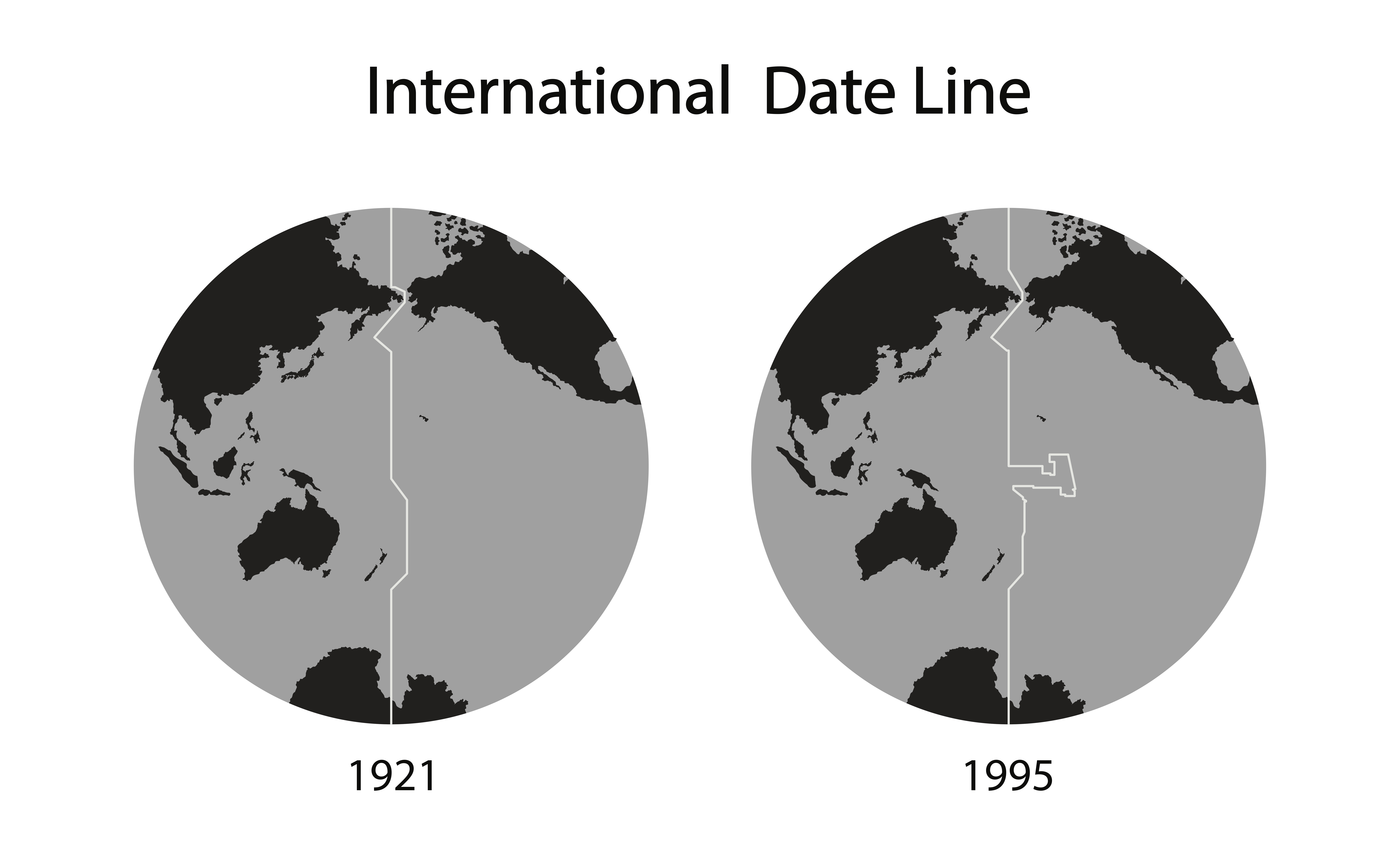
It then tracks back, following the 180-degree meridian south again for several thousand miles, passing west of the Hawaiian Islands and east of the independent nation of the Marshall Islands, until reaching the Pacific island nation of Kiribati. Here, the IDL makes a major deviation east to encompass the Kiribati and Line Islands, the latter of which is also known as the Teraina or Equatorial Islands. This deviation reaches nearly as far east as the 150-degree meridian and forms a very large and noticeable hammerhead-looking configuration.
Kiribati, which received its independence from the United Kingdom in 1979, is a group of 33 mostly uninhabited islands and atolls that span a vast area encompassing no less than 1.9 million square miles (5 million square kilometers). Prior to the 1990s, the IDL bisected the island nation, throwing its western half a day ahead of its eastern half, according to the CIA's World Fact Book. This caused considerable political and economic hardships as the nation tried to conduct normal everyday business with one half of its nation a day ahead and the other a day behind. In 1995, Kiribati decided it had had enough of this arrangement, and seeking greater economic ties with Australia and New Zealand, extended the IDL eastward to encompass the nation's far-flung eastern islands, thus creating the odd configuration.
Shifting the date line is a relatively easy matter, the BBC reported. It doesn’t require the agreement of other countries or the sanction of an international governing body. The country can decide for itself. It’s simply a matter of publicizing the event and informing the international community and map-makers.

Leaving Kiribati, the IDL passes between Samoa and American Samoa, keeping the former west and the latter east of the IDL. It then swerves back sharply toward the 180-degree meridian, but does not follow the meridian's exact path. Instead, it stays parallel to the meridian, keeping to the east of the line so that Tonga, the Kermadec Islands and New Zealand are all east of the IDL.
South of New Zealand, in the vicinity of the Chatham Islands, which are part of New Zealand, the IDL jogs back and connects up again with the 180-degree meridian. It follows this path until reaching Antarctica, which has multiple time zones. The IDL is not drawn into Antarctica on most maps.
Universal Coordinated Time
Today, a method known as Universal Coordinated Time, abbreviated as UTC, has become the timekeeping standard. In essence, it is a more sophisticated version of GMT because it is still based on the zero degrees of latitude that passes through Greenwich but relies on atomic clocks. These devices, invented in the 1950s, are incredibly accurate and are based solely on Earth's rotation. The clocks take into account slight variations in the Earth's rotation rate that can cause timekeeping to vary.
Additional resources
- Further reading: "Plotting the Globe: Stories of Meridians, Parallels, and the International Date Line (Explorations in World Maritime History)" (Praeger, 2005) by Avraham Ariel and Nora Ariel Berger
- Read more about the International Meridian Conference.
- Don't feel like doing math? Here's a helpful time zone converter that will do it for you.
This article has been updated from a previous version written by Dan Helm in 2018.
Sign up for the Live Science daily newsletter now
Get the world’s most fascinating discoveries delivered straight to your inbox.
Tom Garlinghouse is a journalist specializing in general science stories. He has a Ph.D. in archaeology from the University of California, Davis, and was a practicing archaeologist prior to receiving his MA in science journalism from the University of California, Santa Cruz. His work has appeared in an eclectic array of print and online publications, including the Monterey Herald, the San Jose Mercury News, History Today, Sapiens.org, Science.com, Current World Archaeology and many others. He is also a novelist whose first novel Mind Fields, was recently published by Open-Books.com.


