Predicting Where Water Will Go In A Hurricane

Get the world’s most fascinating discoveries delivered straight to your inbox.
You are now subscribed
Your newsletter sign-up was successful
Want to add more newsletters?
Join the club
Get full access to premium articles, exclusive features and a growing list of member rewards.
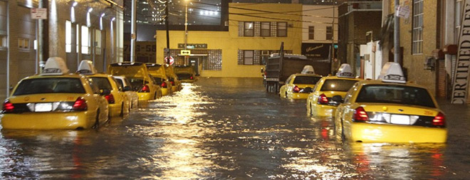
(ISNS) -- In most hurricanes the greatest damage is done not by the wind but from the storm surge, the mountain of water pushed by raging winds from the ocean to deluge the land.
There is always a level of unpredictability when dealing with Mother Nature, but knowing where the water would go when a storm is bearing down on the coast would be useful, particularly in densely populated coastal cities such as New York, which maintains complex systems of houses, office buildings, sidewalks, basements, alleys, subway stations, and streets clogged with parked cars.
Scientists at the College of William & Mary’s Virginia Institute of Marine Sciences at Gloucester Point, Va., reported they have a computer model that may do that, starting about 30 hours before the storm comes ashore. At least it worked in retrospect with the Hurricane Sandy, which devastated the East Coast in 2012.
Article continues belowOther models can predict generally the size of the surge, said Harry V. Wang, a professor of marine science at the institute, but what makes the Virginia model unique, he said, is the application to the landscape.
“People will ask, will that water come into my house, or my building, or submerge my power supply? That’s the big question,” Wang said.
The model, called SELFE was tested by “hind-casting” Hurricane Sandy. They took measurements over an area of the ocean 1,500 miles off the east coast of North America -- Florida to Nova Scotia -- factoring winds, tides, and air pressure during the buildup of Sandy.
Sandy was one of the most destructive storms in American history, with damage particularly severe in Staten Island, N.Y. and the New Jersey shore. Lower Manhattan, particularly around Battery Park and New York Harbor, was also inundated.
Get the world’s most fascinating discoveries delivered straight to your inbox.
Sandy made landfall at 7:30 p.m. on October 29 near Brigantine, N.J. Water from the storm surge got into the New York City subway, closed the three New York area airports and caused $50 billion in damage, some of it still not cleaned up. The tide set records in New York, the Jersey Shore, and Long Island Sound, reaching 12 feet at the Battery.
Sandy was listed as only a Category 1 hurricane when it hit land, but because the impact area was one of the most heavily-populated in the U.S., the damage was extensive.
They let SELFE measure normal tidal conditions for the 10 days before the storm reached the test area, and then five days after the storm's arrival. They took measurements at six-minute intervals using data collected by the National Oceanographic and Atmospheric Administration and from a private company, explained Wang. They chose six minutes because that would allow them to run five days' worth of data in only 40 minutes of computing time, which, he said, made it more useful.
SELFE then predicted where the water would go when it reached land, and Wang and his team matched that with data with what actually happened. They were right to within six to eight inches; they reported in the Journal of Marine Science and Engineering.
Forecasters said they are quite comfortable making predictions of the path of hurricanes 30 hours before they hit land, so Wang said that would give him enough time to predict and broadcast the results.
Asked if his model could have predicted where the water would go in New Orleans in Hurricane Katrina in 2005, Wang said “in theory, yes.”
Jeff Masters, director of meteorology at the Weather Underground, a commercial weather service called the new tool impressive.
One of the key factors in Wang’s model, he said, is Wang’s use of LIDAR, a mapping technique using lasers to make maps -- including contour maps -- of the sea’s surface.
“That’s a big advantage,” he said.
Masters said the research was useful, but warned that scientists still “can’t do that job in real time. They [the Virginia researchers] did an impressive job using data after the fact. You don’t have that data when the storm is actually hitting. That is still a major bottle neck.
“That being said: As we do a better job doing computer models we are going to have models that do that well in real time.”
Accuracy also depends on how good the data collection is. Other scientists have tried it but found their wind speed data was wrong, throwing the entire model off, Masters said.
Alan Blumberg, an oceanographer at the Stevens Institute of Technology in Hoboken, N.J., suggested the scientists next hone their study with crowd-sourcing. After a flood, they should ask the people in the area where the water went building by building.
“The research is a very good start to understanding a very complicated problem,” Blumberg said.
This story was provided by Inside Science News Service. Joel Shurkin is a freelance writer based in Baltimore. He is the author of nine books on science and the history of science, and has taught science journalism at Stanford University, UC Santa Cruz and the University of Alaska Fairbanks. He tweets at @shurkin.
 Live Science Plus


