Powerful Aftershock Shakes Chile

A strong aftershock rattled northern Chile late Wednesday night (April 2), a day after an earthquake of magnitude 8.2 triggered a tsunami in the region, according to the U.S. Geological Survey (USGS).
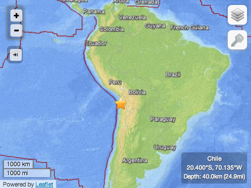
The temblor, which measured 7.6 in magnitude, originated 12 miles (19 kilometers) south of the Chilean port city of Iquique. Its epicenter was 24.9 miles (40 km) deep, and it struck at 11:43 p.m. Tuesday local time (2:43 UTC April 3), the USGS reports.
A tsunami alert prompted the evacuation of low-lying areas along the country's long Pacific coastline, but no new major damage or casualties were reported, according to the Associated Press.
The earthquake was just one of at least 47 aftershocks following the 8.2-magnitude event, which killed six people and set off a tsunami nearly 7 feet (2 meters) high along the coasts of southern Peru and northern Chile.
Chile is no stranger to large tremors, as it sits near a so-called subduction zone, where the Nazca tectonic plate is squeezing under the South America plate. In February 2010, an 8.8-magnitude earthquake — the fifth largest ever measured — struck off Chile's southern Pacific coast, leveling buildings, killing more than 500 people and moving the city of Concepción at least 10 feet (3 m) to the west. The largest earthquake on record, measuring 9.5 in magnitude, ruptured nearby in May 1960, killing 5,700 people.
But the earthquake that hit this week ripped along a stretch of Chile's northern coastline that had been quiet for more than a century. The last big quake to strike near Iquique happened in 1877. Decades' worth of built-up stress set off the recent swarm of earthquakes, with a 6.7 tremor on March 16 kicking off the foreshock sequence near the epicenter of the April 1 earthquake.
The damage caused by any single earthquake depends on the quake's depth and proximity to populated areas, as well as the building standards in the region and the type of earthquake. The USGS frequently updates the magnitude of an event after more data is analyzed.
Get the world’s most fascinating discoveries delivered straight to your inbox.
An earthquake's magnitude is a measure of the energy released at the source. It is just one predictor of the shaking that may ensue, which is affected by local and regional geology. Scientists know in a general sense what causes earthquakes but are unable to predict specific quakes.
This article will be updated if significant additional information becomes available. Find more earthquake news here.
Follow Megan Gannon on Twitter and Google+. Follow us @livescience, Facebook & Google+. Original article on Live Science.


