Meteotsunami to Bear's Cage: 10 Weather Terms to Know this Season

This article was provided by AccuWeather.com.
The polar vortex and bombogenesis, two terms commonly used in meteorology, became social media buzzwords this past winter. Here is a list of 10 additional obscure weather words that could become the next to enter the mainstream this summer.
Dry Punch
A slang term for a surge of dry air, a dry punch can at times increase the risk for severe weather.
"It is generally just a push of dry air into an area of high humidity, often associated with a cold front," said AccuWeather.com Senior Meteorologist Alex Sosnowski. "In the case of general showers and thunderstorms, it could shut them down. In the case of severe thunderstorms, it could be talking about a push of dry air at mid-levels of the atmosphere that often make thunderstorms more severe."
Virga
Virga is the word for precipitation that evaporates before making contact with the surface below. It can be visible from a distance in summer rainstorms, appearing as thin streaks reaching down from the clouds.
Sign up for the Live Science daily newsletter now
Get the world’s most fascinating discoveries delivered straight to your inbox.
This process occurs when air in the upper levels of the atmosphere holds enough moisture for rain to fall, but drier air closer to the Earth's surface cause it to evaporate.
Bear's Cage
A bear's cage, or just bear cage, is a slang term for a particular part of a tornado. Being "in the bear cage" typically means that a storm chaser is in a severe storm that has the potential to spawn, or already has spawned, tornado development.
Anywhere there is rotation in a severe thunderstorm can be a bear's cage.
Fetch
This could be the summer to make "fetch" happen. The word, meteorologically, is relevant to ocean wave heights, according to Sosnowski.
"Fetch is the distance over water a parcel of air can blow across," he said. "The longer the distance over water a single parcel of air can travel without interruption, the bigger the waves on the waters where it is blowing toward. If they create a long, continuous flow of air, say from high pressure to low pressure, the potential near the end to which the wind is blowing toward can yield big waves."
RELATED US Interactive Radar MAP: Severe Watches and Warnings Forecast Temperature Maps
Cyclogenesis
A cyclogenesis is the development of a system around an area of low pressure, leading to cyclonic activity. When warm air and cool air meet around low pressure, it creates movement. This is the term for the early development stages of a cyclone.
Freshet
A freshet is the name for springtime floods caused by snow and ice melt. When winter accumulations, which hold a good deal of moisture, melt with spring rains and rising temperatures, they can slowly overfill creeks and rivers and cause this seasonal flooding.
Meteotsunami
Unlike typical tsunamis, which are the result of seismic activity, meteotsunamis are caused by a weather event, such as a derecho, creating and pushing large waves.
When the waves are created by a weather event like a derecho, it requires more, exact elements to come together for its creation. These elements are harder to track because they occur above the Earth's surface.
Tsunamis and meteotsunamis are more than just large waves, however. Wave frequency and speed are more emphasized factors in applying these labels.
Backdoor Front
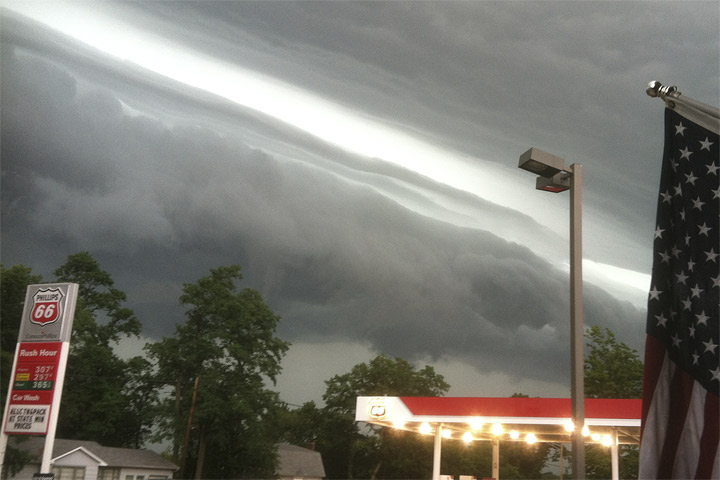
Fronts typically travel from west to east. In a backdoor front, the direction is reversed. As will be seen this week, a backdoor cold front will begin as cold air in the East then push out towards the West.
Mesoscale Convective Complex
A mesoscale convective complex is a type of thunderstorm that occurs at night.
"Daytime thunderstorms usually fire up as the sun warms in the afternoon, and then they fall apart at night," said AccuWeather.com Senior Meteorologist Bernie Rayno. "With MCCs, they thrive at night and then fall apart in the daytime."
These storms are created when warm air travels, say from Texas to the Plains, and meets with colder air aloft. The temperature difference creates storms. When the sun rises and temperatures climb, the temperature difference decreases and the storms fall apart.
According to Rayno, these storms are capable of producing tornadoes, but they aren't likely to. They are more typically associated with bringing downpours and creating flooding. While they are able to occur in multiple locations, Rayno said that they are a critical source of rain in the Plains during the summer.
These storms are large systems. When they occur on a smaller scale, they do not classify as mesoscale convective complexes.
Suction Vortex
Within a tornado, a suction vortex is a small but powerful circulation. These swirling, intense systems are the usual cause of much of the damage associated with the overall tornado.
Have questions, comments, or a story to share? Email Samantha-Rae Tuthill at SamanthaRae.Tuthill@accuweather.com, follow her on Twitter @Accu_Sam or Google+. Follow us @breakingweather, or on Facebook and Google+.
©AccuWeather.com. All rights reserved. More from AccuWeather.com.


