NASA 'Bisects' Tropical Storm Amanda (Photo)

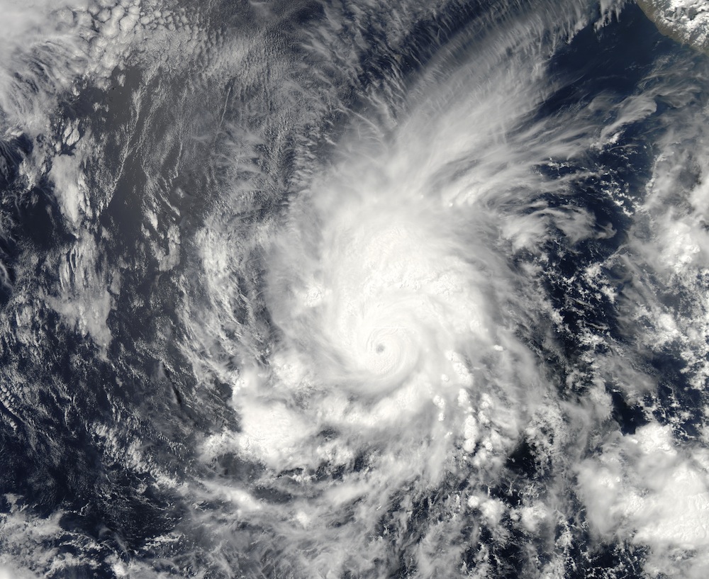
NASA has sliced and diced the first named storm of the 2014 hurricane season, capturing a bisected view of Hurricane Amanda at its strongest.
Amanda — now a tropical depression — formed over Memorial Day weekend and reached Category 4 hurricane strength, with winds reaching 155 mph (250 km/h). Those wind speeds made the storm the strongest May hurricane ever seen. Fortunately, Amanda remained far out to sea in the eastern Pacific and never threatened land. After turning north over cooler waters this week, the storm weakened, its winds receding to tropical-storm level. As of today (May 29), Amanda is a mere tropical depression, with maximum sustained winds of only about 35 mph (56 km/h), according to the National Hurricane Center.
NASA's CloudSat satellite caught a detailed glimpse of the storm when it was still a hurricane. On May 25, the storm's winds were blowing at around 150 mph (240 km/h) when the satellite passed over about 25 miles (40 km) from the center of the storm. [Hurricanes from Above: See Nature's Biggest Storms]
Inside a hurricane

CloudSat uses ultrasensitive radar to measure clouds and their moisture. In Amanda's eastern half, the satellite detected moderate and heavy-moderate precipitation deep in the storm, below the altitude at which precipitation turns from solid into liquid. The profile of the storm revealed an expansive, anvil-shaped cloud extending northward, as well as smaller cumulus clouds underneath, NASA reported today (May 29).
Tropical storms, hurricanes and typhoons form when warm, moist ocean air rises, creating an area of low pressure where cooler air can rush in, and then be warmed and rise in turn. Amanda's strength was at its greatest on May 25, when the storm was over warm equatorial waters. As the storm tracked north, it traveled over cooler waters that could no longer fuel its fury. Shear winds also contributed to weakening the storm.
Tropical storms are defined as storms in which winds reach 39 mph (63 km/h). To qualify as a hurricane, a storm must have wind speeds of 74 mph (119 km/h) or more.
Sign up for the Live Science daily newsletter now
Get the world’s most fascinating discoveries delivered straight to your inbox.
Hurricane season 2014
Amanda was the first named storm of the 2014 eastern Pacific hurricane season, which begins May 15 and ends Nov. 30. Atlantic hurricane season starts shortly thereafter, on June 1, and also runs through Nov. 30.
Storms are named based on an alphabetical list that changes every year. (There are six lists that meteorologists rotate, but the names of extremely deadly or destructive storms are retired, leading to tweaks in the lists.)
The 2013 Atlantic hurricane season was the quietest since 1982, according to AccuWeather. The weather agency predicts a relatively calm 2014 hurricane season as well, particularly if a robust El Niño weather pattern sets up and increases wind shears across the Atlantic, which tends to decrease the number of tropical storms.
Editor's Note: If you have an amazing weather or general science photo you'd like to share for a possible story or image gallery, please contact managing editor Jeanna Bryner at LSphotos@livescience.com.
Follow Stephanie Pappas on Twitter and Google+. Follow us @livescience, Facebook & Google+. Original article on Live Science.

Stephanie Pappas is a contributing writer for Live Science, covering topics ranging from geoscience to archaeology to the human brain and behavior. She was previously a senior writer for Live Science but is now a freelancer based in Denver, Colorado, and regularly contributes to Scientific American and The Monitor, the monthly magazine of the American Psychological Association. Stephanie received a bachelor's degree in psychology from the University of South Carolina and a graduate certificate in science communication from the University of California, Santa Cruz.


