What Caused California's Napa Earthquake?

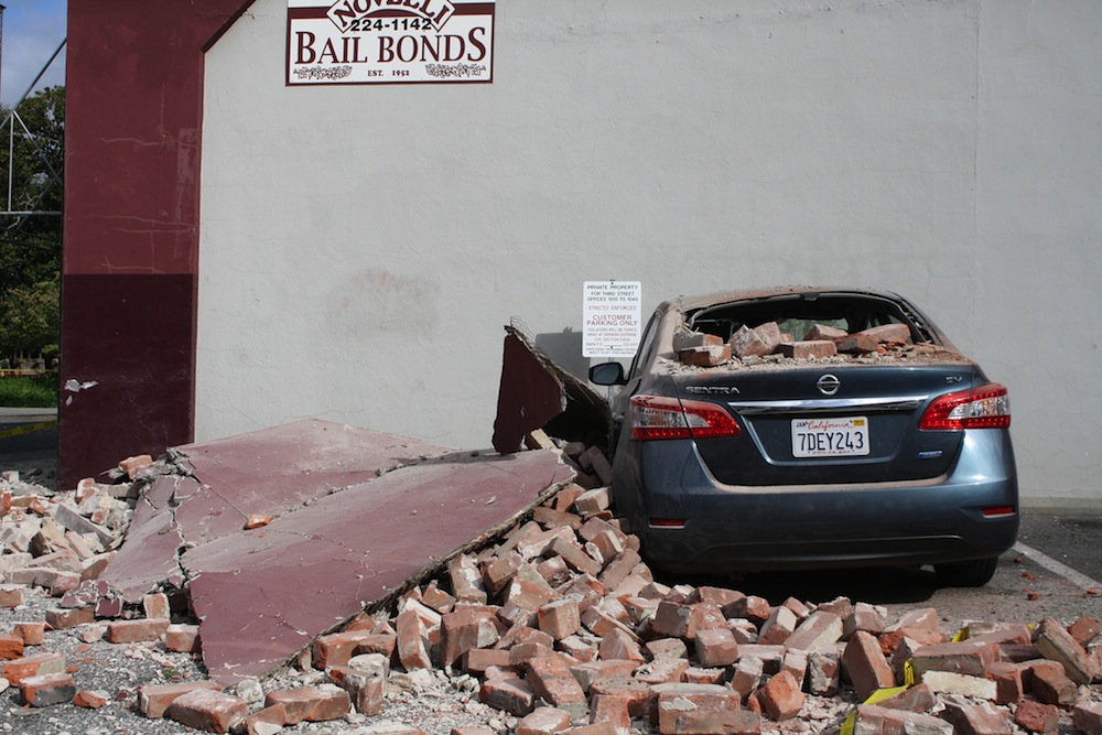
A strong, 6.0-magnitude earthquake jolted Northern California yesterday (Aug. 24) at 3:20 a.m. local time. The earthquake's epicenter was a few miles south of Napa Valley's renowned wineries, and the quake busted barrels and bottles of precious vintages. More than 170 people were injured, and 100 homes are now uninhabitable, the state Office of Emergency Services said Sunday.
In the first uncertain minutes, a seismologist at the U.S Geological Survey's Bay Area headquarters pinned the blame on the Franklin Fault, which has been inactive for thousands of years.
By morning, the sun lay bare what darkness hid: Buckled pavement and cracked curbs lined up along the West Napa Fault for up to 10 miles (16 kilometers). After inspecting the damage, California state geologist John Parrish declared that Sunday's earthquake occurred on the West Napa Fault, not the Franklin Fault. The USGS concurred, tweeting Sunday that the Browns Valley section of the West Napa Fault was the likely culprit. [See photos of damage from the Napa earthquake]
The results are still preliminary, and geologists will make a definitive call in the next few days. However, the early false start highlights how both high-tech instruments and old-fashioned groundwork remain important in the aftermath of an earthquake.
Which fault?
Yesterday's earthquake struck near the Napa Airport, in the San Pablo Bay marshes. The USGS precisely located the epicenter in just a few minutes, thanks to the region's dense seismic monitoring network, said Tom Brocher, director of the USGS Earthquake Science Center in Menlo Park, California. But which fault was at fault?
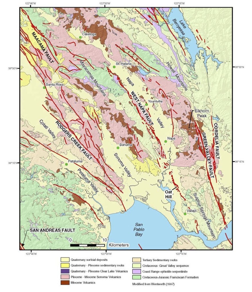
Many suspects appear on state earthquake maps. One is the West Napa Fault, which stretches 35 miles (57 km) from the city of St. Helena south to San Pablo Bay, according to a USGS report published in 2008. Among a handful of other possibilities, the Franklin Fault also stands out. This fault begins near the epicenter of the recent quake, and then cuts south across San Pablo Bay.
Get the world’s most fascinating discoveries delivered straight to your inbox.
West Napa or Franklin? That 4 a.m. guess blaming the Franklin Fault soon seemed wrong. As damage reports poured in, scientists zeroed in on the West Napa Fault's Browns Valley branch.
This fault traces the western margin of the Napa Valley and cuts through the Browns Valley neighborhood of Napa. Along with the damaged streets, many of the city's water main breaks were in the Browns Valley area, according to Napa Valley officials. The Browns Valley branch pierces the Napa River at Cuttings Wharf. Another strand of the West Napa Fault lies east of the river and runs through the Napa Airport.
Why it happened
The West Napa Fault is part of the huge fault zone extending outward from the San Andreas Fault, which lies about 31 miles (50 km) west of Napa Valley. The San Andreas marks the boundary where the Pacific and North American tectonic plates grind past one another. The West Napa Fault is sandwiched between two larger faults: the Hayward-Rodgers Creek Fault and the Concord-Green Valley Fault. [Photo Journal: The Gorgeous San Andreas Fault]
"The plate boundary is really quite wide and quite complicated, and the plate motion is accommodated by a wide network of faults," Brocher told Live Science.
The tectonic tension between the plates trickles inland to the West Napa Fault. An earthquake occurs when this built-up strain is unleashed. The fault parallels the San Andreas, and like the San Andreas, it is a series of slashes in the earth, not a single crack. (Each fault has more than one segment running in parallel.) Each fault is also of a type called right-lateral strike-slip, which means one side of the fault leaps horizontally to the right during an earthquake.
Within the last 11,000 years, the West Napa Fault has created cliffs and ridges called scarps, a sign of past seismic activity. But this fault has never jolted valley residents in historic times.
The last earthquake to rattle the Napa Valley struck on Sept. 3, 2000. This magnitude-5.1 earthquake occurred 10 miles (16 km) northwest of Napa, near Yountville, on a previously unknown fault.
No one knows how often earthquakes rumble through Napa Valley. The West Napa Fault and others nearby have never received the detailed detective work that geologists lavish on faults in the densely settled Bay Area. A 2008 estimate of Bay Area earthquake probabilities conducted by scientists and engineers for the state of California did not include the West Napa Fault.
"It is known to be an active fault, but it certainly has not been viewed as one of the major players in the Bay Area," Brocher said.
Napa's 6.0-magnitude earthquake is the biggest quake in California since the magnitude-6.7 Northridge earthquake in 1994, and the biggest in Northern California since the 1989 Loma Prieta earthquake, a magnitude 6.9.
Collecting clues
But the South Napa earthquake could have been worse. Only part of the West Napa Fault broke open. If the entire fault had ripped, the earthquake would have been more powerful.
"I have to say, as much as the earthquake was large and had a widespread impact, it's not as bad as it could have been," Mark Ghilarducci, director of California's Office of Emergency Services, said during a press conference Sunday.
Though the actual earthquake rupture only lasted four seconds, there was strong shaking in Napa because the valley floor is lined with soft river soils that amplify earthquake waves. Also, the fault zipped open from south to north, directing the earthquake energy toward the city. "It looks like it went northwest and up from the dot on the map that shows where the earthquake nucleated," Brocher said. [13 Crazy Earthquake Facts]
Early Sunday morning, geologists from the USGS, the California Geological Survey and local universities were recording the surface damage before road crews started their repairs. This information will help researchers understand the earthquake's progress during the brief seconds the fault opened and closed.
On the high-tech side, it will take a few more days to measure how much the valley moved during and after the earthquake, using GPS and satellite measurements. An initial GPS report indicated 4 inches (10 centimeters) of shift near the earthquake's epicenter, Brocher said.
Small earthquakes called aftershocks continue to strike along the West Napa Fault. These small quakes cluster along the fault zone and illuminate the hidden underground parts of the fault, and will help scientists nail down which fault caused the quake.
"The locations of the aftershocks indicate that it ruptured the West Napa Fault, but it is not clear yet which strand of that fault broke," said Felix Waldhauser, a seismologist at the Lamont-Doherty Earth Observatory in Palisades, New York. "Over the next couple of days we should have a better picture."
The earthquake is likely to bring new focus to Napa Valley's earthquake hazard. The California Geological Survey had already begun new studies on the Browns Valley branch earlier this year, and more researchers will likely begin studies analyzing the earthquake and its causes.
The quake also highlighted the most forward-reaching technology in California's quake arsenal.
The first jolt triggered the prototype earthquake early warning system at the University of California, Berkeley's Seismological Laboratory. The lab received a 10-second warning before the shaking started, said Lab Director Richard Allen. The warning could have been improved with an upgrade to the ShakeAlert system, which would have boosted the response time of the slowest seismometer by 2.5 seconds, Allen said. The state legislature approved a bill to expand the system statewide in 2013, but the Office of Emergency Services must find $80 million to pay for it.
"While the system clearly worked, the warning could have been twice as fast," Allen said.
Email Becky Oskin or follow her @beckyoskin. Follow us @livescience, Facebook & Google+. Original article on Live Science.


