How Drones Are Fighting Infectious Disease
In a remote area of Southeast Asia, drones are fighting a battle — not against terrorists or insurgents, but against infectious disease.
Researchers on the island of Borneo are using flying robots to map out areas affected by a type of malaria parasite (Plasmodium knowlesi), which most commonly infects macaque monkeys. In recent years, public health officials in the Malaysian state of Sabah have seen a rise in the number of cases of humans infected with this deadly parasite, which is spread, via mosquitos, from macaques to people.
By mapping the communities where these cases occur, researchers hope to figure out why the parasite is spreading from monkeys to people with greater frequency, said Chris Drakeley, a professor of infection and immunity at the London School of Hygiene and Tropical Medicine in the United Kingdom, and one of the researchers involved in the project. [10 Deadly Diseases That Hopped Across Species]
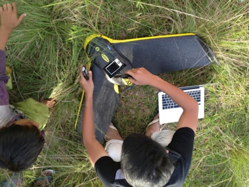
Drakeley and his colleagues used a small, camera-carrying drone called a senseFly eBee to create maps and digital surface models of the land and vegetation surrounding communities where P. knowlesi has turned up in humans. The drone can fly for up to 50 minutes and carries a 16-megapixel digital camera.
"What we're doing is creating a detailed map, which we can then superimpose or overlay with the human and the macaque movement," Drakeley told Live Science. The movement patterns of both monkeys and humans were derived from GPS data. Locals were asked to carry around GPS tracking devices, while certain macaques were fitted with GPS collars.
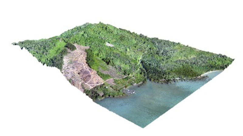
The hope is that this GPS data will help the researchers pinpoint where humans and macaques are most likely to interact, and the drones will show the researchers what these areas look like and help them figure out why both species might be drawn to those areas.
Old disease, new hypothesis
Sign up for the Live Science daily newsletter now
Get the world’s most fascinating discoveries delivered straight to your inbox.
In the past, it was fairly easy to track the spread of P. knowlesi to humans, Drakeley said. The disease tended to show up only in adult men who had spent time in the forest, where they were working on logging operations. The thinking was that mosquitos that had previously fed on macaques infected with P. knowlesi were biting these men, causing malaria.
"It was thought to be a relatively rare and specific kind of interaction," Drakeley said. "But what the Malaysians we've worked with in the state of Sabah have described is that this actually isn't always the case."
Recently, the disease has been affecting children, as well as whole families or other clusters of individuals, the researchers said. In other words, P.knowlesi is now infecting people who haven't been spending time in the forest.
Butresearchers are still unsure what's causing the spread of the monkey parasite, Drakeley said. One idea is that the disease is spreading because of changes in the way the land is being used. Still, exactly what kind of land use causes macaques and humans to get too close to each other is something the researchers have yet to determine. The drone project, however, is providing researchers with some fresh clues.
For example, the drone footage has helped the researchers confirm that cornfields aren't just popular with the farmers who tend them; they're also havens for corn-stealing macaques, Drakeley said. The researchers have also noted the clearing of what they call "secondary forests" to make way for other small-scale farming operations, such as the planting of oil palms.
"Secondary forests" are made up of trees that macaques use as paths to get from one point to another, Drakeley said. Cutting down these trees — even only a few of them — means the monkeys may have to move closer to people's homes or other settlements to get where they're going.
Nevertheless, Drakeley was quick to point out that this small-scale deforestation isn't necessarily what's causing the spread of P. knowlesi. The problem is more complex, he said, which is why the researchers are being careful about how they map the spread of the disease.
Flying detectives
In addition to using drones to photograph the local communities affected by this malaria parasite, the researchers are also collecting information about the macaques that host the parasite. During a recent flight, one drone was outfitted with an infrared sensor that let the researchers see not only where macaques were congregating, but also how many of the animals tended to gather in one area, Drakeley said.
The drones can also be used to monitor likely breeding grounds for mosquitos, which are carriers of the disease. Pinpointing where these insects breed around settlements could help researchers determine how P. knowlesi is spreading.
The idea of taking to the skies to gain a broader perspective isn't new. For years, epidemiologists have relied on satellite imagery and sensors to monitor the movement of animals capable of spreading diseases to humans, according to Stephen Morse, a professor of epidemiology at the Mailman School of Public Health at Columbia Universityin New York City.
Morse, who has tracked the spread of disease in both the United States and Africa, cited the work of Rita Colwell, an environmental microbiologist, who uses satellite imagery to predict cholera outbreaks around the world. Others have used satellite images to locate so-called "dambos" in Africa. Dambos, or shallow wetlands, are known breeding grounds for mosquitos that spread the Rift Valley fever virus to both humans and livestock.
But drones may be a more viable source of information than costly satellite images, Morse said. "I think there are a lot of advantages to drones — the relatively low cost, the fact that you can get much closer and get much finer detail," he told Live Science.
Morse said the use of drones to track P. knowlesi in Malaysia is "ingenious."
"It's good they're pioneering this because it seems like a pretty natural use for something that we've already developed," he said.
The researchers in Malaysia did consider using satellite imagery to map the local landscape, but the clouds that often hang over the island of Borneo make satellite images less useful, Drakeley said.
Drones also enabled the researchers to map subtle changes in the landscape on a consistent basis, Drakeley said. This is important for keeping maps up-to-date and for tracking any changes in land use.
"There's no question that land-use change is one of the major drivers of emerging infections," Morse said. Clearing land for farming and venturing further into forested land, he said, are known causes for the start of deadly outbreaks of diseases, such as Ebola, in humans.
An in-depth article about the researchers' use of drones in Malaysia was published online today (Oct. 22) in the journal Trends in Parasitology.
Follow Elizabeth Palermo @techEpalermo. Follow Live Science @livescience, Facebook & Google+. Original article on Live Science.

Elizabeth is a former Live Science associate editor and current director of audience development at the Chamber of Commerce. She graduated with a bachelor of arts degree from George Washington University. Elizabeth has traveled throughout the Americas, studying political systems and indigenous cultures and teaching English to students of all ages.
