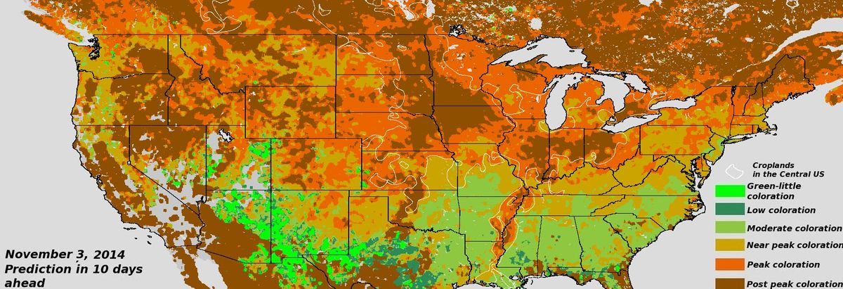
Map Predicts Stunning Fall Foliage 10 Days Ahead

There's still time to catch the peak of colorful fall leaves in many parts of the county, and a new foliage forecast map can help you plan a scenic viewing trip more than a week ahead of time.
The map shows the best fall leaf colors 10 days out, based on images from the Suomi NPP weather satellite's Visible Infrared Imager Radiometric Suite. The sensor tracks vegetation changes in visible light and in infrared. The forecast is updated every three days.
Areas that will be at peak leaf color in 10 days are shown in orange on the map, and regions near peak color are highlighted in yellow. Parts of the country already past their leaf-viewing prime are marked in brown. Expect low to moderate leaf colors where the map is colored green.
Scientists at South Dakota State University (SDSU) and the National Oceanic and Atmospheric Administration developed the method to monitor and predict leaf color changes as part of a three-year effort to document the effects of climate change on vegetation.
"We are the first to use satellite imagery to observe the fall colors and make predictions," SDSU senior scientist Xiaoyang Zhang, one of the project leaders, said in a statement.
The researchers also plan to monitor the start of spring planting season, droughts and disease outbreaks in forests, among other vegetation changes.
Both the forecast and a map of current fall color conditions are available online at NOAA's Center for Satellite Applications and Research.
Sign up for the Live Science daily newsletter now
Get the world’s most fascinating discoveries delivered straight to your inbox.
Follow Becky Oskin @beckyoskin. Follow Live Science @livescience, Facebook & Google+. Originally published on Live Science.


