Devastating Floods in Texas, Oklahoma Driven by El Niño

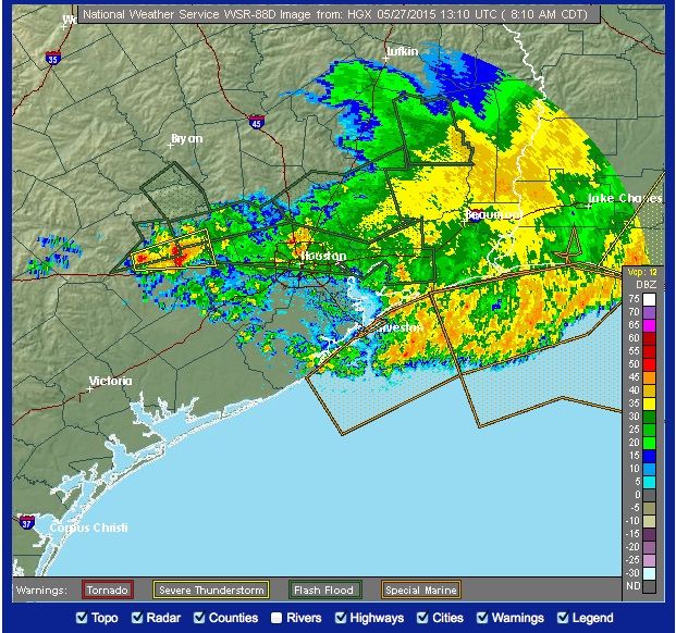
Severe floods in Texas and Oklahoma are causing devastation after multiple storm systems battered a formerly drought-stricken area, according to experts.
Heavy rainfalls began on Saturday (May 23) and soaked the region through the weekend, leading to nearly record-breaking rains in some southern areas of Texas and Oklahoma. Flash flooding and tornadoes have also been reported in certain cities and towns. At least 10 people have been reported dead across Oklahoma and Texas, and thousands have been evacuated from their homes and are seeking temporary shelter.
These catastrophic conditions are being caused by an El Niño pattern — a natural climate cycle that brings warmer-than-average temperatures to the Pacific Ocean — that has split the jet stream into two branches, with one river of air going off north and the other one sinking farther to the south, said John Gresiak, a senior forecaster for AccuWeather. It is the southern stream that is causing the disturbances in Texas and Oklahoma, after passing through California and Mexico, he added. [Fishy Rain to Fire Whirlwinds: The World's Weirdest Weather]
"Just looking at San Antonio, as of this date they've had double their rainfall for May, and they'll probably get more," Gresiak told Live Science.
The area has been experiencing severe drought for about five years, so residents are no longer used to the large amounts of rainfall that typically fall at this time of year, said Walt Zaleski, the warning coordination meteorologist for the regional headquarters of the National Weather Service (NWS) in Fort Worth, Texas.
"It's not out of the ordinary for us to be getting severe storms that produce thunderstorms and hail," he told Live Science.
While this "drought-buster" rainfall is a welcome relief to cities that had been facing lower-than-usual reserves, the amount of rain that has come all at once has been difficult for residents to deal with, he said. In just four months, the water has replenished lakes that were previously 20 to 25 feet (6 to 8 meters) below normal levels.
Sign up for the Live Science daily newsletter now
Get the world’s most fascinating discoveries delivered straight to your inbox.
Flash flooding, which occurs suddenly when an intense amount of rain falls over a short period of time, has also been an issue. In Wimberley, Texas — a town just southwest of Austin — the Blanco River rose to 40 feet (12 m) from 9 feet (2.7 m) in just 2.5 hours, Zaleski said.
There won't be a reprieve yet from the water, as severe storms are expected to remain in the forecast. For the next couple of days, however, meteorologists at the NWS are expecting the worst of the storms to hit west of Texas, where fewer people live. Regions that are farther east may get battered again with severe weather toward the end of the week, Gresiak said.
Follow Live Science @livescience, Facebook & Google+. Original article on Live Science.

Elizabeth Howell was staff reporter at Space.com between 2022 and 2024 and a regular contributor to Live Science and Space.com between 2012 and 2022. Elizabeth's reporting includes multiple exclusives with the White House, speaking several times with the International Space Station, witnessing five human spaceflight launches on two continents, flying parabolic, working inside a spacesuit, and participating in a simulated Mars mission. Her latest book, "Why Am I Taller?" (ECW Press, 2022) is co-written with astronaut Dave Williams.


