'Furry' Clouds Create Spectacular Effect Over Ocean (Photo)

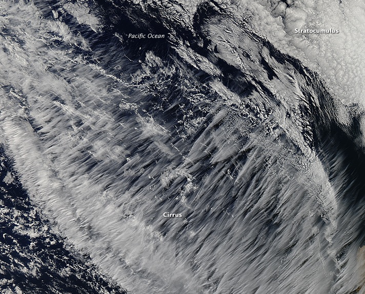
Wispy, featherlike clouds off the coast of Chile appear to cover the Pacific Ocean in white fur in a newly released satellite photo.
The natural-color image, taken May 21 by NASA's Aqua satellite, shows high-altitude clouds diagonally sweeping across the frame. Although the hairlike quality of the clouds identifies them as cirrus, their exact type is less obvious, according to NASA scientists.
"Most clouds are classified by what they look like from below, making it difficult to identify them from satellite using the classic system," Patrick Minnis, an atmospheric scientist at NASA's Langley Research Center in Hampton, Virginia, said in a statement. [See photos of the craziest-looking clouds]
Cirrus clouds can form when water-droplet-rich clouds rise and cool into ice-crystal-rich clouds. The wispy billows in the satellite photo likely formed at high altitudes along the jet stream, Minnis said. The peaks of the clouds extend up to 8 miles (13 kilometers) high, Minnis said, which is almost equivalent to 30 Empire State Buildings stacked on top of one another. The winds in the photo were blowing at about 100 mph (161 km/h), he added.
From the ground, the clouds may look cirrostratus, which means they fill the sky and radiate a halo effect caused by the reflection of the ice crystals, or refraction of light. From space, however, the clouds appear to be either cirrus fibratus or cirrus radiatus — terms that refer to the clouds' hairlike quality and straight parallel bands, respectively.
The term "cirrus" is Latin for a "curl" or "tuft of hair." Ann Fridlind, a researcher at NASA's Goddard Institute for Space Studies in New York City, said the shape of the clouds is sometimes known as "mares' tails." These clouds are not particularly unusual, she said, but they make for an arresting image.
Cirrus clouds can indicate fair temperatures for the area they cover. If they look patchy from the ground, expect dry, sunny and calm weather, according to WeatherOnline.
Get the world’s most fascinating discoveries delivered straight to your inbox.
In the upper-right corner of the image, stratocumulus clouds appear at a much lower altitude than the cirrus clouds. These fluffy clouds form over relatively cool ocean water, where atmospheric chemistry keeps the clouds low.
Follow Live Science @livescience, Facebook & Google+. Original article on Live Science.


