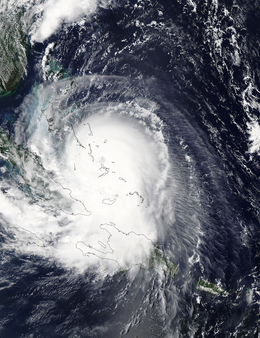
NASA Satellite Spies Hurricane Joaquin Replacing an Eye

Hurricane Joaquin, a Category 4 storm that is currently battering the central Bahamas, appears to be replacing its eye, according to weather forecasters.
New satellite views of the intense hurricane appear to show the storm's eye obscured, which could indicate that a new eye is forming around the old one, NASA said. This process, known as eyewall replacement, occurs naturally in powerful tropical cyclones. (Tropical cyclones that form in the Atlantic or eastern Pacific are called hurricanes, while those that form in the western Pacific and southeastern Indian Ocean are dubbed typhoons.)
During eyewall-replacement cycles, a new outer eyewall — a swirling mass of clouds that rotates around the center of a storm — forms. This eventually cuts off inflow to the existing eye and replaces it altogether. Such an event typically weakens a hurricane, but the replacement can also blow hurricane-force winds over a more sprawling area, according to NASA. [Hurricanes from Above: See Images of Nature's Biggest Storms]
The agency's Aqua satellite snapped photos of Hurricane Joaquin over the Bahamas yesterday (Oct. 1), with the storm's eye clearly visible. However, when the National Oceanic and Atmospheric Administration's GOES-East satellite passed over the area 12 hours later, clouds appeared to cover the eye, NASA officials said.
Hurricane Joaquin is currently churning over the Bahamas, delivering heavy rainfall and maximum sustained winds of approximately 130 mph (209 km/h) to the area. But over the next 24 hours, "some fluctuations in intensity are possible due to eyewall-replacement cycles," the National Hurricane Center said in an update posted today (Oct. 2) at 11 a.m. EDT.
The storm is slowly drifting northwest and is expected to accelerate its northward movement tomorrow (Oct. 3), away from the Bahamas. Early forecasts showed the hurricane possibly making landfall along the U.S. East Coast, but models now indicate the storm's track has shifted eastward and the hurricane will likely not hit any part of the U.S. mainland.
Still, even though the storm is expected to head out to sea, heavy rain and flooding are predicted for a wide swath of the Southeast and mid-Atlantic, according to the National Weather Service. The agency's flood outlook predicts that as much as 12 inches (30 centimeters) of rain could fall over parts of Georgia and South Carolina.
Sign up for the Live Science daily newsletter now
Get the world’s most fascinating discoveries delivered straight to your inbox.
The latest forecasts can be accessed on the National Hurricane Center's website.
Follow Denise Chow on Twitter @denisechow. Follow Live Science @livescience, Facebook & Google+. Original article on Live Science.

Denise Chow was the assistant managing editor at Live Science before moving to NBC News as a science reporter, where she focuses on general science and climate change. Before joining the Live Science team in 2013, she spent two years as a staff writer for Space.com, writing about rocket launches and covering NASA's final three space shuttle missions. A Canadian transplant, Denise has a bachelor's degree from the University of Toronto, and a master's degree in journalism from New York University.


