How El Niño Made the Pacific a Hurricane Hotbed in 2015
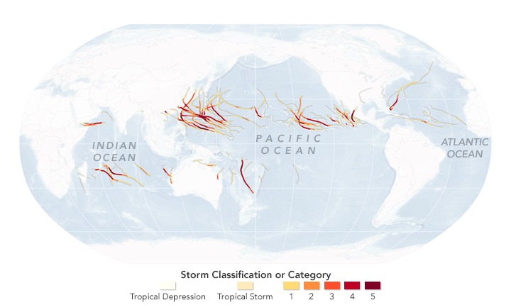
A record-breaking number of furious storms rocked the Pacific Ocean during the 2015 hurricane season, while the Atlantic Ocean stayed relatively quiet, likely because of El Niño, new research shows.
El-Niño-influenced storms raged throughout the Pacific during this year's six-month hurricane season, which lasted from June 1 to Nov. 30. Even the central Pacific Ocean and the northwest Indian Ocean saw cyclones, a rare occurrence, according to a report at NASA's Earth Observatory. (Hurricanes, cyclones and typhoons refer to the same type of storms that form in different places.)
But the Atlantic spent its third consecutive year with below-average storm activity, the Earth Observatory reported. [50 Amazing Hurricane Facts]
In contrast, 30 major hurricanes, typhoons and cyclones blasted the Northern Hemisphere this year, seven more than in 2004, the last record-setting year. Furthermore, 25 of the 30 storms reached a status of Category 4 (winds at 130 to 156 miles per hour; 209 to 251 kilometers per hour) or Category 5 (winds 157 mph or 252 km/h or higher), far more than the previous record of 18, EO said.
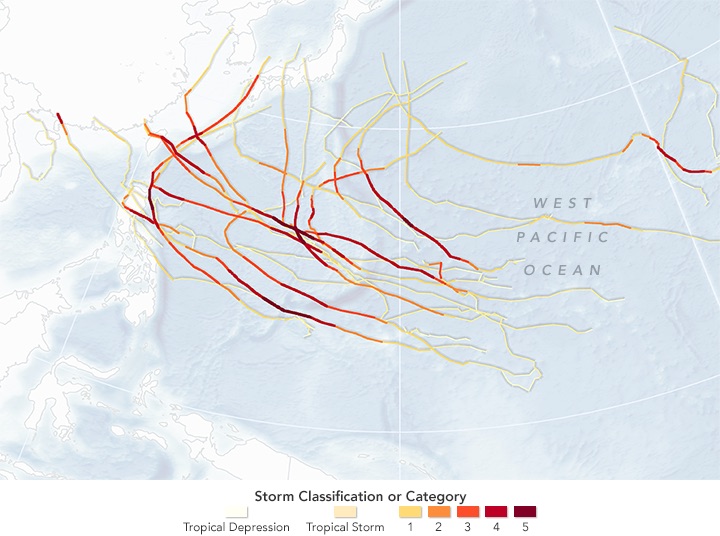
"The 2015 season broke pretty much every prior record for that portion of the Northeast Pacific basin," Phil Klotzbach, a research meteorologist at Colorado State University, said in a statement. "That portion of the basin had record-warm sea-surface temperatures and record-low vertical wind shear [changes in wind speed or direction across a short distance], a prime combination for hurricane intensification and maintenance."
The record-breaking warm water temperatures were largely a result of El Niño's strong influence, according to the Earth Observatory. Once warmed, these waters likely contributed to the 18 named storms, including 13 hurricanes, nine of them major (Category 3 or higher), that happened during 2015 — the greatest number on record since reliable measurements started in 1971.
For instance, Hurricane Patricia grew into the strongest hurricane ever recorded in the Western Hemisphere, with winds approaching 200 mph (230 km/h) as it neared Mexico in October.
Sign up for the Live Science daily newsletter now
Get the world’s most fascinating discoveries delivered straight to your inbox.
Farther west, the middle of the Pacific Ocean was a hotbed of fierce storms. This area, the north central Pacific, had 14 named storms and eight cyclones (five of them major) that formed there or moved through it, Klotzbach said. The last record for the region was four cyclones in 1982, he added.
In August, three major hurricanes ripped through the area east of the International Date Line at the same time, the first time meteorologists have seen such a thing, according to the Earth Observatory (EO).
Atlantic winds
Meanwhile, tropical storm Ana raised eyebrows after it formed in the Atlantic. Ana developed off the southeastern coast of the United States in early May, about a month ahead of the typical hurricane season, the EO said. But the Atlantic quieted down afterward, with 11 named storms, including four hurricanes, with no major storms making landfall.
Still, the Atlantic gave meteorologists a few scares: Fred became the easternmost hurricane on record, slamming into the Cape Verde islands off the West African coast in September. Hurricane Kate hit the Bahamas in November, making it one of the only storms to hit the islands so late in the hurricane season, the EO reported. [Famous Examples of the 5 Hurricane Categories]
Researchers at the National Oceanic and Atmospheric Administration (NOAA) said El Niño is likely responsible for the quiet year in the Atlantic.
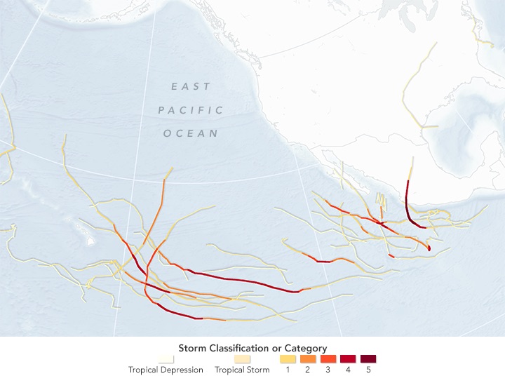
"El Niño produces a see-saw effect, suppressing the Atlantic season while strengthening the eastern and central Pacific hurricane seasons," Gerry Bell, the lead seasonal hurricane forecaster at NOAA's Climate Prediction Center, said in a statement. "El Niño intensified into a strong event during the summer and significantly impacted all three hurricane seasons during their peak months."
In addition, strong wind shear in the Atlantic zapped energy from brewing storms there, while weak wind shear in the central Pacific allowed many hurricanes and typhoons to develop.
The western Pacific, a region near Asia and the Oceania islands, had a season filled with intense storms: 15 major typhoons, matching records set in 1958 and 1965. Again, El Niño is likely to blame, as small drops in water temperature and wind push storms father east, Klotzbach said.
2015 had a number of other record-breaking events, he said.
- Just 12 hurricanes developed in the Atlantic basin from 2013 to 2015, the lowest in the region since 1992 to 1994.
- The United States hasn't had a major hurricane hit its shores since Wilma lashed southern Florida in 2005. "The United States has never had a 10-year period without a major hurricane landfall, eclipsing the previous record of eight years set from 1861 to 1868," Klotzbach said.
- The northeastern Pacific experienced so many intense cyclones that it reached its second-highest "accumulated cyclone energy" value ever on record: 288, versus the record-hitting 292 in 1992. Meteorologists use this value to measure the intensity of each hurricane season.
- The North Central Pacific had record-high average sea-surface temperatures and record-low average wind shear.
Follow Laura Geggel on Twitter @LauraGeggel. Follow Live Science @livescience, Facebook & Google+. Original article on Live Science.

Laura is the archaeology and Life's Little Mysteries editor at Live Science. She also reports on general science, including paleontology. Her work has appeared in The New York Times, Scholastic, Popular Science and Spectrum, a site on autism research. She has won multiple awards from the Society of Professional Journalists and the Washington Newspaper Publishers Association for her reporting at a weekly newspaper near Seattle. Laura holds a bachelor's degree in English literature and psychology from Washington University in St. Louis and a master's degree in science writing from NYU.
