'Breathing' Volcano: How Scientists Captured This Awesome Animation

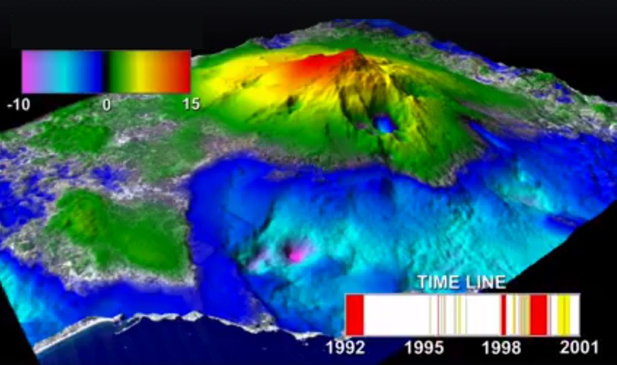
Mount Etna seems to breathe in a NASA animation showing how changes in the volcano's magma chamber deform the ground around the mountain.
Mount Etna is an active volcano on the Italian island of Sicily. Its last eruption — a small one — occurred on March 31, according to the Smithsonian Institution's Global Volcanism Program. Reports of Etna's rumblings date back thousands of years. The Greek historian Diodorus Siculus wrote of Etna's eruptions in his "Bibliotheca historica," a series of volumes written between 60 B.C. and 30 B.C.
Though much of Mount Etna's recent activity is relatively contained, the volcano has threatened people and dwellings in the past. A large eruption devastated several villages in 1669, and a 1928 eruption sent lava flowing through the village of Mascali, almost entirely destroying it. Among the volcano's many recent eruptions was a fiery nighttime display caught on video in 2014. [Watch the Animation of Mount Etna Breathing]
Because of its well-known activity and proximity to population centers, Mount Etna is carefully monitored. The NASA animation, originally released in 2012 but circulating this week on social media, shows some of that data.
Researchers used radar interferometry, a technique that relies on the change in radio waves that bounce off the ground, to create this animation. Two European Space Agency satellites (European Remote Sensing 1 & 2) passed over Etna, beaming down radar waves from orbit. These radar waves hit the ground and bounced back. Changes in the waves as they returned to the satellites revealed changes in the level of the ground surface below. Over time, researchers were able to create a 3D model of how the Earth's surface changed while the satellites orbited.
In this animation, Etna's slopes ebb and flow as its magma chamber inflates and deflates between 1992 and 2001. The chamber is about 3 miles (5 kilometers) below sea level, according to NASA's Jet Propulsion Laboratory. The color-coded bar in the upper-left corner of the video shows how much the ground is rising and falling — a total range of about 10 inches (25 centimeters). On the lower right, a timeline shows periods of severe eruption in red, moderate eruption in yellow and periods of quiet in white. The time period shown begins with Etna's last major eruption, in 1992.
Change is constant on Mount Etna's slopes. In one week in August 2014, for example, an eruptive episode built a new peak on the volcano's New Southeast Crater, according to the Global Volcanism Program.
Sign up for the Live Science daily newsletter now
Get the world’s most fascinating discoveries delivered straight to your inbox.
Follow Stephanie Pappas on Twitter and Google+. Follow us @livescience, Facebook & Google+. Original article on Live Science.

Stephanie Pappas is a contributing writer for Live Science, covering topics ranging from geoscience to archaeology to the human brain and behavior. She was previously a senior writer for Live Science but is now a freelancer based in Denver, Colorado, and regularly contributes to Scientific American and The Monitor, the monthly magazine of the American Psychological Association. Stephanie received a bachelor's degree in psychology from the University of South Carolina and a graduate certificate in science communication from the University of California, Santa Cruz.


