Monstrous Hurricane Matthew Towers Over Tropical Storm Nicole (Photo)
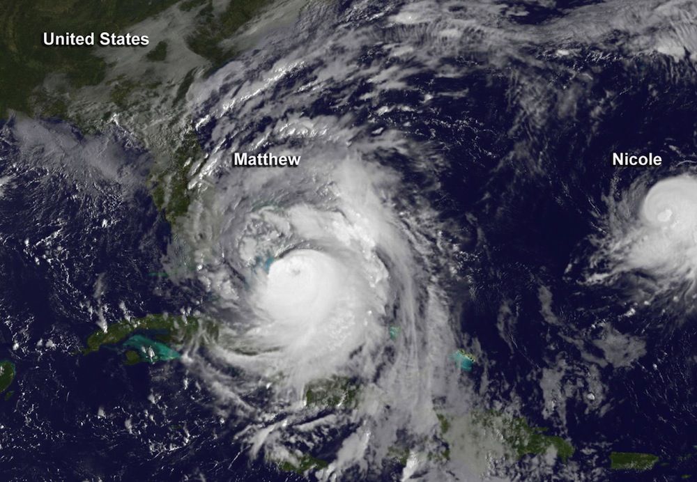
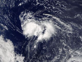
Tropical Storm Nicole looks like a minor rain shower next to the monstrous Hurricane Matthew in a new satellite image.
Though Nicole was less than half the size of Matthew, the tropical storm was approaching hurricane strength when this image was taken, according to the National Hurricane Center (NHC). Maximum winds were around 70 mph (110 km/h). [See Photos of Hurricane Matthew]
As of 2:00 p.m. EDT today (Oct. 6), Nicole officially became a hurricane, with maximum sustained winds blowing at 80 mph (130 km/h). NHC forecasters predict that the storm will continue to strengthen slightly over the next day before beginning to weaken.
Hurricane Matthewis a much greater threat to human life. As of 11 a.m. EDT today (Oct 6), the storm boasted maximum sustained winds of around 140 mph (225 km/h) and was headed toward Florida at about 14 mph (22 km/h). Hurricane warnings were in effect from Golden Beach, Florida, to Edisto Beach, South Carolina, and for Lake Okeechobee in Florida. A hurricane watch is in effect from Edisto Beach to the South Santee River in South Carolina, and evacuations are underway along the Atlantic coast; more than 2.5 million people have been ordered to evacuate along the coast from Florida to South Carolina, according to The Washington Post.
The juxtaposition of Matthew and Nicole comes courtesy of the National Oceanic and Atmospheric Administration (NOAA). The agency's GOES East satellite captured the visible-light shot at 7:45 a.m. EDT today. Hurricane Matthew obscures eastern Cuba, Hispaniola (which comprises Haiti and the Dominican Republic) and much of the Bahamas, with the outer bands of the storm extending to Florida. The storm temporarily weakened to Category 3 status on Wednesday (Oct. 5) but is now a Category 4 hurricane on the Saffir-Simpson Hurricane Scale. The National Hurricane Center warns that hurricane conditions will likely reach parts of Florida by later today and spread throughout the entire warning area by Friday.
In the GOES East satellite image, Nicole sits about 400 miles (640 km) south of Bermuda. The storm is expected to make slow, meandering movements through Friday, with a turn toward the north-northwest later today. NASA's Terra satellite also caught an image of the tropical storm — which has no visible eye — on Oct. 5 at 10:35 a.m. EDT. Nicole's impact to land and coastlines is likely to be restricted to ocean swells and rough surf in Bermuda, according to the NHC.
Matthew's rise has been fueled by warm ocean waters, high moisture in the air and favorable winds, experts say. Measurements at the hurricane's cloud tops before it made landfall in Haiti indicated low temperatures (less than minus 70 degrees Fahrenheit, or minus 57 degrees Celsius), which is correlated with heavy rainfall. As of Wednesday, damage reports from Haiti had begun to trickle in, with Haiti Libre reporting that 14,530 people had been displaced by the storm.
Sign up for the Live Science daily newsletter now
Get the world’s most fascinating discoveries delivered straight to your inbox.
Original article on Live Science.

Stephanie Pappas is a contributing writer for Live Science, covering topics ranging from geoscience to archaeology to the human brain and behavior. She was previously a senior writer for Live Science but is now a freelancer based in Denver, Colorado, and regularly contributes to Scientific American and The Monitor, the monthly magazine of the American Psychological Association. Stephanie received a bachelor's degree in psychology from the University of South Carolina and a graduate certificate in science communication from the University of California, Santa Cruz.
