Mount St. Helens Update: A Slow Boil

After recent visible tantrums, Mount St. Helens continues this week to quietly build a dome in its central crater with a constant, slow eruption of lava.
Now researchers have a new way to track changes in the size of the dome and the entire mountain with high-powered lasers.
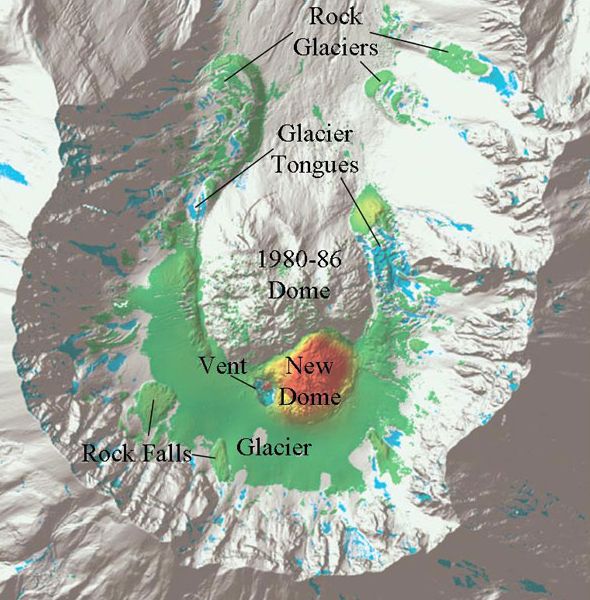
Increased seismic activity at the end of September warned geologists of the creation of a new lava dome. Laser observations made Oct. 14 showed the dome was growing at a rate of seven cubic meters per second (247 cubic feet per second), roughly the volume of a small apartment.
New technique
The U.S. Geological Survey (USGS) partnered with NASA to employ an advanced laser system that maps the growth of the dome and helps scientists develop models to predict volcanic hazards.
Called high-tech Light Detection and Ranging (LIDAR) the instrument is mounted on a small aircraft and the laser scans the ground measuring the distance from the airplane to the surface several tens of thousands of times a second.
"This is the first time USGS and NASA have teamed to use LIDAR to measure volcano deformation," USGS scientist Rob Haugerud said recently.
Sign up for the Live Science daily newsletter now
Get the world’s most fascinating discoveries delivered straight to your inbox.
A LIDAR survey of Mount St. Helens from September 2003 provided a baseline for comparing the Oct. 4, 2004 survey that showed the new dome in the crater had grown to the height of a 35-story building and covered the surface area of 29 football fields.
Geologists also gather data about the change in a volcano's shape by measuring distances on the ground with benchmarks and the satellite-based Global Positioning System (GPS). Over the long term the USGS uses satellites to take pictures at various times and overlay them to further compare changes.
"GPS data provide us with very accurate point measurements of deformation, but only at locations where we can place an instrument," Linda Mark, a hydrologist at the USGS Cascades Volcano Observatory, told LiveScience, "used together the two methods complement each other."
"The LIDAR surveys have been very useful," Mark explained. "The models help us quantify the ongoing deformation in the crater of Mount St. Helens." Another LIDAR survey had been flown on Oct. 14 and an additional survey is scheduled for early November.
Different types of eruptions
Mount St. Helens had been quiet since 1857 when in 1980 activity culminated with the major eruption on May 18 that killed 57.
Unlike that violent eruption -- caused by high-pressure gases escaping -- the current outflow of lava lacks a high gas content and could continue to build the central crater without incident, scientists said. The most intense steam and ash eruption of this event occurred on the morning of Oct. 5. Since then the volcano has remained relatively calm.
Scientist from the observatory constantly measure minor earthquakes and gases from the volcano, however, to monitor any changes that could presage another more volatile eruption.
Although the threat of an explosive eruption is low, mudflows continue to pose a danger, geologists said Thursday. When the heat of the volcano melts snow or glaciers the water can combine with the loose sediment to create a searing, fast moving flood that can threaten people and animals in its path.
The tools scientist use at the surface are increasingly comprehensive and detailed, but the inner workings of a volcano are still largely unknown, geologists say. "I think that now is a very exciting time to be working at Mount St. Helens," Mark said.


