The Weather Forecast for August, September and October? Hot!

Get the world’s most fascinating discoveries delivered straight to your inbox.
You are now subscribed
Your newsletter sign-up was successful
Want to add more newsletters?
Join the club
Get full access to premium articles, exclusive features and a growing list of member rewards.
Grab that iced tea — much of the U.S. has had a hot summer so far, and it's only going to get hotter, according to a report released today (July 20) by the National Oceanic and Atmospheric Administration (NOAA).
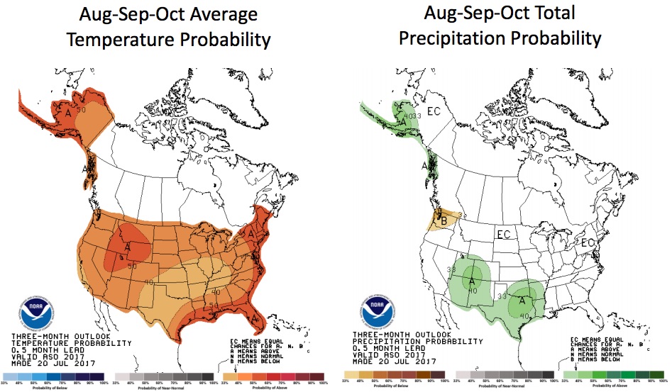
For the next three months — August, September and October — the United States is predicted to have above-average temperatures, Dan Collins, a meteorologist and seasonal forecaster with the NOAA Climate Prediction Center-Operational Prediction Branch, said in news briefing today.
"You can see that across the entire United States, including Alaska, there is more of a chance that temperatures will be above normal," Collins said. [8 Ways Global Warming Is Already Changing the World]
Article continues belowThe three-month forecast for rain showed that parts of Alaska, as well as the American Southwest and South, will have more rain than they typically do during the late summer and early fall. In contrast, parts of the Pacific Northwest are expected to have less rain than usual during that time, NOAA's precipitation map showed.
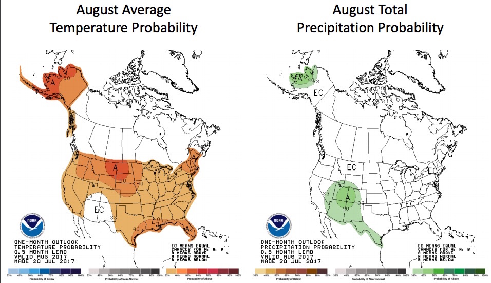
In August, most of the country will have warmer-than-usual temperatures, with the exclusion of the Southwest (parts of Arizona, Utah, Colorado, New Mexico and Texas). The main reason the Southwest won't have a hotter-than-normal August is because more rain than usual is expected in that area, Collins said.
There are several reasons for these above-normal temperatures. One is due to increased ridging in the atmosphere over the northern-central U.S. This means that "the circulation of the atmosphere is such that there is higher pressure in that region," which leads to higher temperatures, Collins said.
Moreover, long-term trends — that is, climate change — are playing a significant role this season. The NOAA Climate Prediction Center uses the past three decades as a reference period, and the "most recent decade is somewhat warmer than the previous three decades, from 1981 to 2010," Collins said.
Get the world’s most fascinating discoveries delivered straight to your inbox.
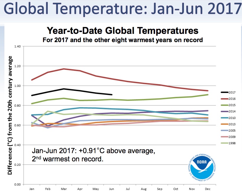
NOAA experts also detailed global weather trends. This June was 1.4 degrees Fahrenheit (0.82 degrees Celsius) above the 20th-century average, said Jake Crouch, a climate scientist at NOAA's National Centers for Environmental Information-Climate Monitoring Branch. It was also the third-warmest June on record — only June 2015 and June 2016 were warmer, Crouch said.
That makes it the 41st consecutive June and the 390th consecutive month that was warmer than average, he noted.
While 2017 isn't as hot as 2016 was — the latter had El Nino to heat it up (El Nino is associated with warm waters in the Pacific Ocean changing the air-surface pressure and atmospheric circulation) — it's on track to be the second-warmest year in recent history.
Original article on Live Science.

Laura is the managing editor at Live Science. She also runs the archaeology section and the Life's Little Mysteries series. Her work has appeared in The New York Times, Scholastic, Popular Science and Spectrum, a site on autism research. She has won multiple awards from the Society of Professional Journalists and the Washington Newspaper Publishers Association for her reporting at a weekly newspaper near Seattle. Laura holds a bachelor's degree in English literature and psychology from Washington University in St. Louis and a master's degree in science writing from NYU.
 Live Science Plus


