Is West Texas Sinking Into a Hole of Its Own Making?

Parts of West Texas are sinking — and other parts quaking and shaking — thanks to oil and gas extraction.
A new study using satellite data to measure ground changes near Pecos, Monahans, Wink and Kermit, Texas, finds multiple disturbances, including places where the ground is sinking up to 4 inches (10 centimeters) a year. In one spot, the ground dropped so much that it formed a new lake, Lake Boehmer.
This area of the oil-rich Permian basin is relatively sparsely populated, but hydrocarbon extraction there is booming, and the area is crisscrossed with roadways and pipelines for moving oil and gas. [See These Insane Photos of Sinkholes]
"The network is enormously dense," said study researcher Zhong Lu, a geophysicist at Southern Methodist University in Dallas. This infrastructure is threatened by the shifting ground, Lu told Live Science.
Man-made change
Lu and his colleagues measured the ground changes as part of a wider project examining how human activities are altering the Gulf Coast. West Texas is a big place, Lu said, and many of the hotspots for ground movement are fairly small, on the order of 0.6 miles (1 kilometer) or so across. To pinpoint these relatively small regions, the researchers turned to two satellites, the European Space Agency's Sentinel 1A and 1B. These satellites launched in 2014 and 2016, respectively. Among other things, the satellites use radar to measure changes in land surfaces over time. [7 Ways the Earth Changes in the Blink of an Eye]
The team focused on a 100-mile by 100-mile (160 by 160 kilometers) square in West Texas, just south of the New Mexico border and slightly southwest of the cities of Midland and Odessa. Within that square, they searched for changes of at least centimeters per year that covered areas of between 200 square meters and 2 square kilometers (about 650 square feet to 1.2 square miles).
They found many. In two areas, the ground was actually rising slightly. At two wells on the border of Winkler and Loving counties, the surface had risen 2.16 inches (5.5 cm) over the study period, probably because of the injection of wastewater from well-drilling below the surface. Similarly, part of the North Ward Estes Field, which is in Ward and Winkler counties, saw an uplift of just over an inch (3 cm) from 2014 to 2017, likely due to the injection of carbon dioxide into the rock to pressurize the reservoir and enhance oil recovery.
Sign up for the Live Science daily newsletter now
Get the world’s most fascinating discoveries delivered straight to your inbox.
Settling down
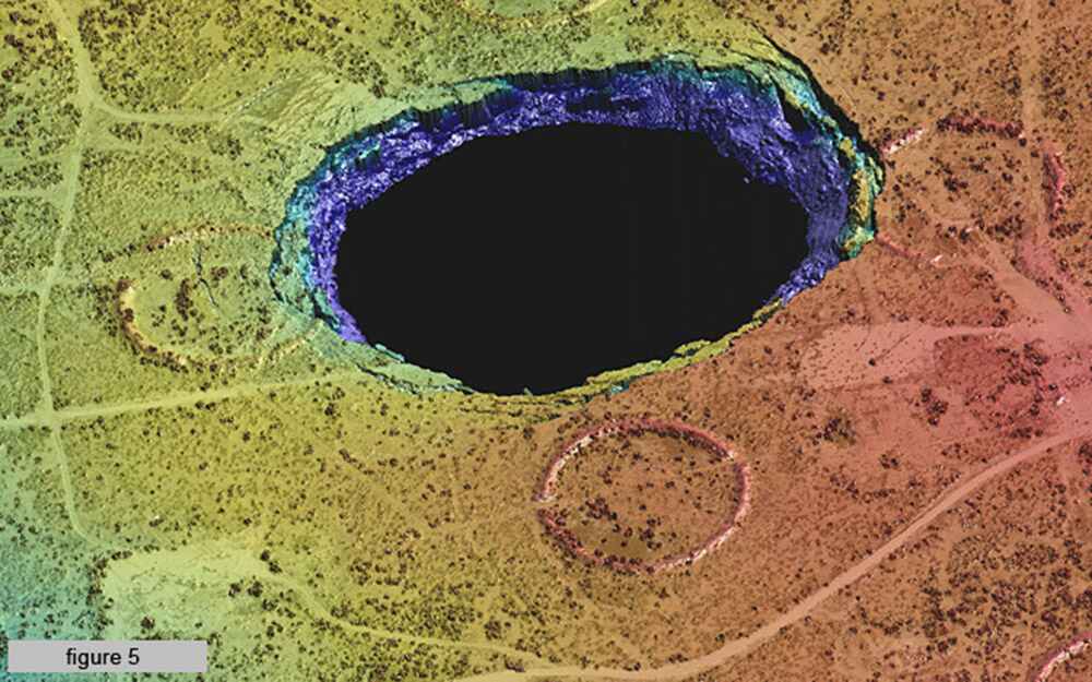
In many other spots, the ground was not rising, but sinking. Near Wink and Imperial, Texas, old wells that have been abandoned but not properly plugged with cement have allowed freshwater to seep into the ground, dissolving salt formations deep under the surface. As voids open up underground, they can cause the surface to sink or collapse. Near Wink, a sinkhole opened up in 1980 and another in 2002; the ground around these sinkholes is still dropping down by about 1.5 inches (4 cm) a year, Lu and his colleagues found.
Near Imperial, subsidence from leaky wells that were in some cases drilled 50 years ago has caused major problems. Boehmer Lake, a brackish body of water just south of town, didn't exist until 2003, Lu said.
"Now there is a lake!" he said.
Farm-to-Market Road 1053 near the lake is sinking by 4 inches (10 cm) a year, Lu and his team discovered. That road has been closed due to its instability.
And at the Santa Rosa Spring southwest of the town of Grandfalls, the ground is also dropping. The surface level has gone down by 9 inches (23 cm) total since 2014, the satellite data revealed. This subsidence is probably also caused by the dissolution of salt formations below the surface, Lu said, though it's not totally clear how or why the salt is dissolving so rapidly.
Finally, the research team discovered about 1.7 inches (4.5 cm) of subsidence at Wolfbone Field, south of the town of Pecos. This field has also been the site of six small earthquakes, one in 2015 and five in 2017. The ground is likely slumping at Wolfbone Field because of the large amount of oil removed from the subsurface since 2015, Lu and his team wrote in the journal Scientific Reports. The same changes could make temblors more likely, they added.
Li and his team are funded by NASA to investigate the man-made geological changes along the Gulf Coast, and they still have two more years to complete that project, which will cover West Texas all the way to northern Florida. They're now attempting to get funding to study the rest of the Permian Basin in West Texas, as well. Monitoring the changing landscape will help in coming up with new methods to prevent further sinking, sliding and quaking, Lu said.
Editor's Note: This article was updated to correct the spelling of Zhong Lu's last name.
Original article on Live Science.

Stephanie Pappas is a contributing writer for Live Science, covering topics ranging from geoscience to archaeology to the human brain and behavior. She was previously a senior writer for Live Science but is now a freelancer based in Denver, Colorado, and regularly contributes to Scientific American and The Monitor, the monthly magazine of the American Psychological Association. Stephanie received a bachelor's degree in psychology from the University of South Carolina and a graduate certificate in science communication from the University of California, Santa Cruz.


