Oil Slick from Rig Collapse Seen from Space

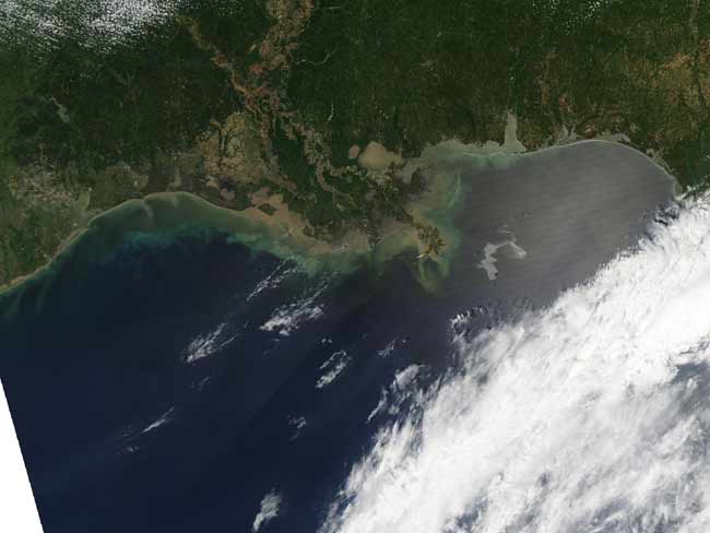
The oil slick that is expanding from the site of an oil rig collapse last week has been spotted from space by a NASA satellite.
An estimated 42,000 gallons of oil per day are leaking from an oil well in the Gulf of Mexico after an oil rig caught fire and then sank into the ocean waters last week.
The only oil evident in the water at first was that which had been on the rig itself at the time it exploded on April 20. Over the weekend, officials working on the oil spill discovered that water was also leaking from the pipe that led up to the rig from the well some 5,000 feet (1,524 meters) below on the seafloor.
NASA's Aqua satellite took a photograph of the affected area on Sunday, April 25, in which the oil slick — which currently covers an area 48 miles long (77 kilometers) and 39 miles wide (63 km), according to news reports — can be seen.
The Mississippi Delta is the center of the image, and the oil slick is a silvery swirl in the lower right. The oil slick may be particularly obvious because it is occurring in the sunlit area, where the mirror-like reflection of the sun off the water gives the Gulf of Mexico a washed-out look.
The slick may contain dispersants or other chemicals that emergency responders are using to control the spread of the oil, and it is unknown how much of the 700,000 gallons of fuel that were on the oil rig burned in the fire and how much may have spilled into the water when the platform sank.
An emergency response effort is underway to stop the flow of oil and contain the existing slick before it reaches wildlife refuges and beaches in Louisiana and Mississippi.
Sign up for the Live Science daily newsletter now
Get the world’s most fascinating discoveries delivered straight to your inbox.
- FAQ: The Science and History of Oil Spills
- Images: SOS! Major Oil Disasters at Sea
- How Are Oil Spills Cleaned?


