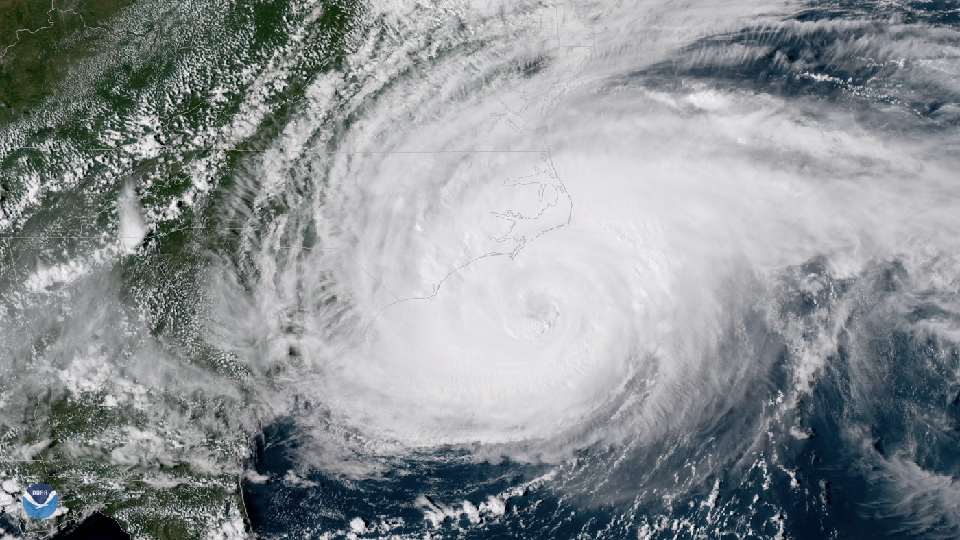
Center of the Eye of Hurricane Florence Makes Landfall Near Wrightsville Beach, NC

Updated at 7:35 a.m. ET, Friday (Sept. 14).
The center of the eye of Hurricane Florence, packing sustained winds of up to 90 mph (150 km/h), just made landfall near Wrightsville, North Carolina, at around 7:30 a.m. ET, according to news reports and the National Hurricane Center (NHC).
"Life-threatening storm surge and rainfall" are expected in portions of the Carolinas and Virginia, according to the NHC. Florence could dump 20 to 30 inches of rain on southeastern coastal North Carolina into far northeastern South Carolina, with isolated areas receiving 40 inches, according to the NHC. "This rainfall will produce catastrophic flash flooding and prolonged significant river flooding."
As of 5 p.m. ET today (Sept. 13), the eye of Hurricane Florence was churning about 100 miles (160 km) east-southeast of Wilmington, North Carlina, the NHC reported.
"Little change in strength is expected before the center reaches the coast, with weakening expected after the center moves inland." the NHC said.
Hurricane experts expect the storm to slow its forward motion through today into Friday (Sept. 14), the NHC reported. The storm is forecast to continue its approach toward the coasts of the Carolinas tonight, before moving near or over the coast of southern North Carolina and eastern South Carolina in the "hurricane warning" area; currently, that area includes South Santee River, South Carolina, to Duck, North Carolina as well as Albemarle and Pamlico Sounds. [Hurricane Season 2018: How Long It Lasts and What to Expect]
The governors of both states, North and South Carolina, issued mandatory evacuations of coastal areas yesterday (Sept. 10), according to CNN.
Sign up for the Live Science daily newsletter now
Get the world’s most fascinating discoveries delivered straight to your inbox.
Large swells are already affecting Bermuda and parts of the U.S. East Coast, according to the NHC. Such swells can lead to dangerous surf and rip currents, the NHC warned. [Hurricane Florence: Photos of a Monster Storm]
Warm sea surface temperatures and low wind shear (which, when high, can zap the energy from a storm) had set up perfect conditions for Florence to intensify. Though the NHC couldn't pinpoint with certainty the exact location and magnitude of the impacts, they said, "interests at the coast and inland from South Carolina into the mid-Atlantic region should closely monitor the progress of Florence, ensure they have their hurricane plan in place, and follow any advice given by local officials."
The governors of Virginia, North Carolina and South Carolina have declared states of emergency, according to CNN.
"We are preparing for the worst, and of course hoping for the best," South Carolina Gov. Henry McMaster said, as reported by CNN.
Original article on Live Science.
Jeanna Bryner is managing editor of Scientific American. Previously she was editor in chief of Live Science and, prior to that, an editor at Scholastic's Science World magazine. Bryner has an English degree from Salisbury University, a master's degree in biogeochemistry and environmental sciences from the University of Maryland and a graduate science journalism degree from New York University. She has worked as a biologist in Florida, where she monitored wetlands and did field surveys for endangered species, including the gorgeous Florida Scrub Jay. She also received an ocean sciences journalism fellowship from the Woods Hole Oceanographic Institution. She is a firm believer that science is for everyone and that just about everything can be viewed through the lens of science.


