Hurricane Florence Shifts Course, Will Make a 'Grand Tour' of Southeastern States
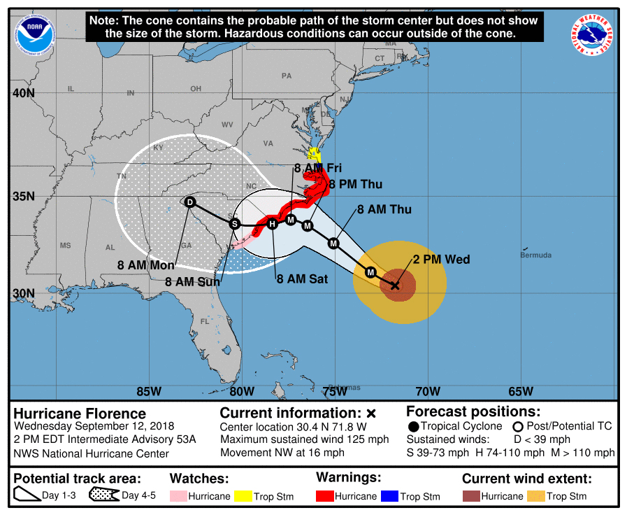
After making landfall this Friday (Sept. 14), the massive storm will now "wobble" southward and then head west, making a "big, grand tour" of the southeastern United States, U.S. Fish and Wildlife Service (FWS) meteorologist Kevin Scasny said in a statement released today (Sept. 12).
Florence, now a Category 4 storm with sustained winds of 130 mph (209 km/h), was previously expected to travel north, up the North Carolina coast, after making landfall, according to the statement. Its new path indicates that after arriving in the area near Wilmington, North Carolina, the storm will dip to the south before resuming a western course, the FWS explained in the statement. [Hurricane Florence: Photos of a Monster Storm]
"We have seen a dramatic shift in the track," Scasny said, adding that big changes to the storm's behavior could emerge within the next two days.
The hurricane is expected to weaken into a tropical depression as it continues westward into South Carolina and Georgia. Eventually, Florence will veer north into the Appalachian Mountains, bringing soaking rains to Virginia and western North Carolina, before sputtering out late next week near Delaware and Maryland, the FWS reported.

Florence is also expected to lose speed and "hover" once it reaches the coast, which will intensify the impacts of its heavy rainfall and storm surges, Ken Graham, director of the National Hurricane Center (NHC), said in a Facebook Live update earlier today.
The storm will slow down because of pushback from a trough — an extended area of low atmospheric pressure — currently over Texas, Stacy Stewart, an NHC senior hurricane specialist, said in the update.
As the trough moves east, it will disrupt the winds that steer the hurricane, Stewart said. That leaves the "spinning wheel" at the hurricane's core stranded, "and it'll just sit there until the weather pattern changes," he said.
Sign up for the Live Science daily newsletter now
Get the world’s most fascinating discoveries delivered straight to your inbox.
Though Florence won't be making landfall until Friday, tropical-storm-force winds — 39 to 73 mph (63 to 117 km/h) — will begin whipping through coastal regions as early as tomorrow, making it exceptionally dangerous to be outside, Graham said.
"Today is the time to get your preparedness actions complete," he said. And if local officials recommend evacuation, evacuate immediately. "If they're telling you to leave, you have to leave," Graham said. "This is a life-and-death situation."
Original article on Live Science.

Mindy Weisberger is an editor at Scholastic and a former Live Science channel editor and senior writer. She has reported on general science, covering climate change, paleontology, biology and space. Mindy studied film at Columbia University; prior to Live Science she produced, wrote and directed media for the American Museum of Natural History in New York City. Her videos about dinosaurs, astrophysics, biodiversity and evolution appear in museums and science centers worldwide, earning awards such as the CINE Golden Eagle and the Communicator Award of Excellence. Her writing has also appeared in Scientific American, The Washington Post and How It Works Magazine. Her book "Rise of the Zombie Bugs: The Surprising Science of Parasitic Mind Control" will be published in spring 2025 by Johns Hopkins University Press.


