The torrential rains that have inundated India with the arrival of Cyclone Laila were measured and tracked from space by a NASA satellite.
Cyclone Laila came ashore along the coast of India at the state of Andhra Pradesh, lashing the area with winds of 60 mph (100 kph) and heavy rains, according to news reports.
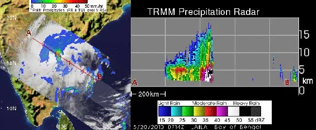
NASA's Tropical Rainfall Measuring Mission (TRMM) satellite captured an image of Laila's rainfall on May 20 and revealed some areas of heavy rainfall.
Latest Videos From
TRMM data shows that the heaviest rainfall appeared just southeast of the center of circulation of the storm (around which the huge bands of storms clouds rotate), and over land (along the coast). That area was generating rainfall of about 2 inches (5 centimeters) per hour.
The torrential rains have already trigged large landslides in the area and forced the evacuations of many low-lying towns, according to news reports.
Cyclones are another name for the same phenomenon as hurricanes and typhoons — the term used depends on what part of the world the storm is in.
TRMM can also observe the heights of the storm's clouds and probe what are called "hot towers," rain clouds that reach at least to the top of the troposphere, the lowest layer of the atmosphere. Hot towers can extend approximately nine miles (14.5 kilometers) high in the tropics. These towers are called "hot" because they rise to such altitudes due to the large amount of latent (or pent-up) heat they hold. Water vapor releases this latent heat as it condenses into liquid.
The storm has also caused rough seas, and the India Meteorological Department has warned fisherman to stay out of the ocean.
The storm came ashore close to the town of Bapatla, one of the historical towns and mandals (an administrative division) of Guntur District.
The U.S. Navy’s Joint Typhoon Warning Center projects that the storm, which is heading to the north-northwest, will weaken after it encounters more rugged terrain to the northeast of Andhra Pradesh.