Wow! Jets Punch Holes in Clouds and Create Rain
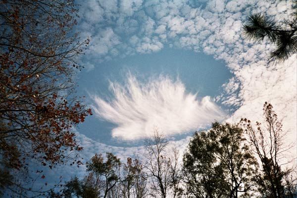
Aircraft can accidentally punch holes in clouds, leaving a trail of snow or rain in their wake, a new study finds.
Turboprop and jet aircraft that climb or descend under certain atmospheric conditions can inadvertently trigger what's known as cloud seeding. This technology is usually associated with schemes to control the weather. However, cloud seeding can happen by accident as planes soaring through mid-level clouds leave behind odd-shaped holes or channels in the clouds and cause narrow bands of snow or rain to develop and fall to the ground.
Holes punched in clouds are a phenomenon that has been recognized for many years and seen in photos from around the world. A front-page feature on Yahoo! carried the headline "A Halo over Moscow" after photos emerged of just such a hole in October 2009.
The secret behind these mysterious clouds has now been revealed: Supercooled water droplets that remain liquid even at subfreezing temperatures — below about 5 degrees Fahrenheit (minus 15 degrees Celsius). When an airplane cuts through clouds containing the supercooled water droplets, air is cooled behind aircraft propellers or over jet wings, and these water droplets freeze and drop toward Earth.
"Any time aircraft fly through these specific conditions, they are altering the clouds in a way that can result in enhanced precipitation nearby," said study co-author Andrew Heymsfield of the National Center for Atmospheric Research (NCAR) in Boulder, Colo.
Hole-punched clouds and accidental cloud seeding may be more common in regions such as the Pacific Northwest and western Europe where cloud layers with supercooled droplets are more common, Heymsfield said.
Speculation on the how the cloud holes formed dates back to the 1940s. Aviation-related hypotheses ranged from acoustic shock waves produced by jets, to local warming of the air along a jet’s path, to the formation of ice along jet contrails.
Sign up for the Live Science daily newsletter now
Get the world’s most fascinating discoveries delivered straight to your inbox.
To unravel the mystery, Heymsfield and his colleagues set to the skies with a battery of instruments in tow. When they flew through some falling snow west of Denver International Airport in 2007, the research team did not notice anything unusual at the time. Once on the ground, a closer analysis of their data revealed a few peculiar anomalies.
Ground-based radar revealed an unusual echo in the area, indicating that the snow had evolved quickly and was unusually shaped. Also, the aircraft's camera recorded a hole in an otherwise solid deck of altocumulus clouds, as well as a burst of snow extending to the ground.
The final piece of the puzzle came when the researchers scrutinized the snowflakes within the snow beneath the hole-punch. These plate-shaped crystals showed evidence of what's known as riming — the accumulation of liquid water — whereas ice particles elsewhere in the cloud showed little or no riming." This tells us that the aircraft literally 'seeded' the cloud just by flying through it," Heymsfield said.
"You wouldn’t necessarily see it from satellite or from the ground. I had no idea this was happening. I was sitting in back of the plane. And then this data set just fell in our laps. It was a lucky break," Heymsfield added.
The study will be published in the June edition of the Bulletin of the American Meteorological Society.
- Gallery: Reading the Clouds
- The World's Weirdest Weather
- Can You See a Sonic Boom?


