Iceberg Collision Forces Redraw of Antarctic Maps

An iceberg that collided with Antarctica has broken a piece of the continent off, forcing maps of the bottom of the world to be redrawn, European scientists said today.
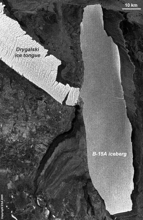
The iceberg, named B-15A, is whopping 71 miles (115 kilometers) long. Scientists predicted an imminent collision back in January. Instead, the iceberg ran aground and stalled out. Then it broke free last month.
Now it has finally collided with the continent's Drygalski ice tongue and smacked a city sized chunk of it into the ocean.
The frigid carnage is visible in a new satellite image from the European Space Agency (ESA). The picture was taken April 15 and released today.
The Drygalski ice tongue sticks out into the McMurdo Sound on the Ross Sea and figures into maps of the region. The tongue is about 44 miles (70 kilometers) long. Or at least it was.
The broken-off piece is about 3 miles (5 kilometers) long.
B-15A is the largest chunk left of a bigger iceberg, known as B-15, that broke off the Ross Ice Shelf in March 2000. That initial frozen hunk was about the size of Jamaica. After B-15 broke apart, the chunk named B-15A drifted into McMurdo Sound, where it blocked ocean currents and caused other sea ice to build up, threatening wildlife.
Sign up for the Live Science daily newsletter now
Get the world’s most fascinating discoveries delivered straight to your inbox.
More collisions between the iceberg and Drygalski are possible, the scientists said.
Related News
- New Large Iceberg Breaks off Antarctica
- Soot Could Hasten Melting of Arctic Ice
- Ice Ages Blamed on Tilted Earth
Uplink Your Views
Robert is an independent health and science journalist and writer based in Phoenix, Arizona. He is a former editor-in-chief of Live Science with over 20 years of experience as a reporter and editor. He has worked on websites such as Space.com and Tom's Guide, and is a contributor on Medium, covering how we age and how to optimize the mind and body through time. He has a journalism degree from Humboldt State University in California.


