El Nino Forms, Throttling Hurricane Formation
El Nino conditions have developed in the tropical Pacific and are likely to continue into early 2007, scientists announced yesterday.
El Nino is marked by warmer water in the Pacific off the coast of South America. It alters weather patterns in the United States and throttles hurricane formation in the Atlantic by pumping energy high into the atmosphere and fueling wind currents that cross the Americas and shear the tops off some Atlantic storms before they can develop into hurricanes.
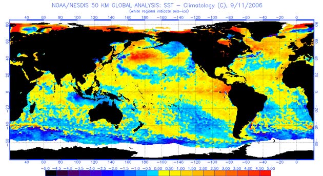
Researchers had said in August El Nino might be forming; ocean temperatures increased remarkably in the equatorial Pacific during the last two weeks [map].
"Currently, weak El Nino conditions exist, but there is a potential for this event to strengthen into a moderate event by winter," said Vernon Kousky, NOAA's lead El Nino forecaster.
The shift helps explain why this Atlantic hurricane season has been less active than was previously expected, according to a NOAA statement.
But with El Nino weak, the effects on hurricanes are modest.
"We are still in the peak months of the Atlantic hurricane season, and conditions remain generally conducive for hurricane formation," said Gerry Bell, NOAA's lead seasonal hurricane forecaster.
Sign up for the Live Science daily newsletter now
Get the world’s most fascinating discoveries delivered straight to your inbox.
If El Nino continues to hold, the United States should expect wetter-than-average conditions over portions of the Gulf Coast and southeastern states in the first three months of 2007, and warmer-than-average conditions would likely settle in over the West, the northern Great Plains and the upper Midwest.

