Ancient Lava Flow Photographed from Space

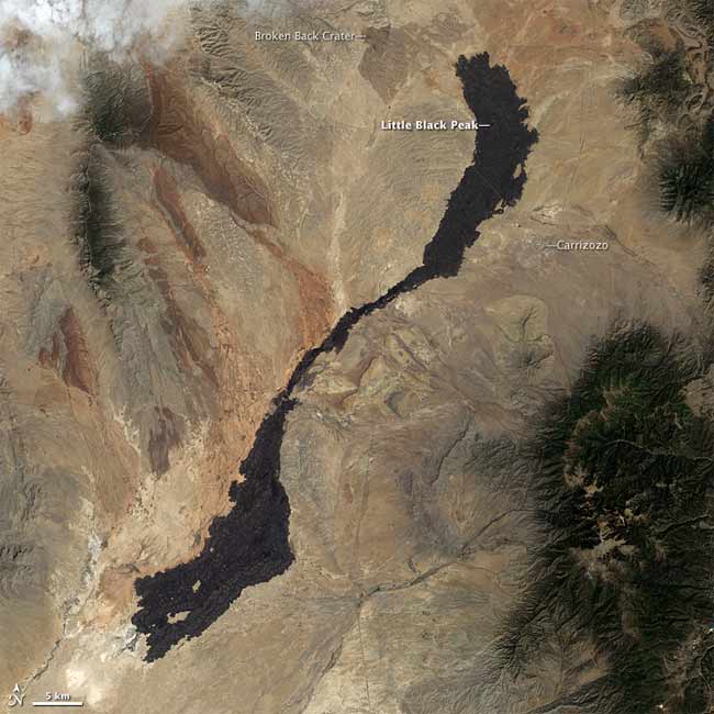
In south-central New Mexico, a massive lava flow stretches some 47 miles (75 kilometers) across the desert landscape. Know as the Carrizozo Malpais, it is left over from volcanic activity that occurred several thousand years ago, and is one of Earth’s longest known lava flows from the Holocene Epoch (the geologic time span since the end of the Pleistocene Ice Age).
A NASA satellite, called Landsat 7, captured this photo-like image of Carrizozo Malpais on May 18, 2003 using its Earth-observing instrument, the enhanced Thematic Mapper. NASA released the image this week.
Like a dumbbell, the flow varies in length from 0.6 miles (1 kilometer) along the middle, to 3 miles (5 kilometers) at either end. Its dark color comes from basalt, a type of volcanic rock that tends to flow easily.
The high point on Carrizozo is Little Black Peak, which is a cinder cone — a simple type of volcano made from congealed droplets and blobs of lava that erupted from a single vent.
Geologists suspect that this huge lava flow occurred in a single episode that lasted 20 to 30 years, and they believe the surface of Carrizozo is roughly 5,200 years old. An older, less conspicuous lava flow emanated from Broken Back Crater to the north. The town of Carrizozo is near the lava flow’s northeastern end. The dark patches to the southeast and northwest of the lava flow are not volcanic rock, but rather, vegetation-lined hills.
- All About Volcanoes
- Image Gallery: Wild Volcanoes
- How Volcanoes Work
Sign up for the Live Science daily newsletter now
Get the world’s most fascinating discoveries delivered straight to your inbox.


