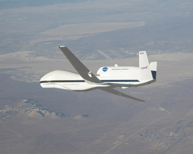
NASA Drones to Fly Into Hurricanes


Scientists have no idea why some tropical storms become hurricanes and some do not. NASA is on a mission to get to the bottom of this problem.
NASA scientists will fly three aircraft, including an unmanned drone, over tropical cyclones in the Gulf of Mexico, Atlantic Ocean and Caribbean Sea during the agency's first major United States-based hurricane field campaign since 2001.
One of the major challenges in tropical cyclone forecasting is knowing when a tropical cyclone (the general term that encompasses hurricanes and tropical storms) is going to form. Researchers will try to unravel this mystery during the GRIP mission, which stands for Genesis and Rapid Intensification Processes. The mission will study how tropical storms form and develop into major hurricanes, as well as how they strengthen, weaken and die.
Article continues belowThe mission will run from Aug. 15 to Sept. 30 and will feature for the first time in hurricane research an unmanned drone that can peer through cloud tops and measure the internal structure of a storm. Previous hurricane research missions relied solely on piloted aircraft, which can observe a storm for between two to four hours — getting only a snapshot of a storm that can spin for days.
"This is really going to be a game-changing hurricane experiment," said GRIP team member Ramesh Kakar of NASA. "For the first time, scientists will be able to study these storms and the conditions that produce them for up to 20 hours straight. GRIP will provide a sustained, continuous look at hurricane behavior at critical times during their formation and evolution."
Spinning storms
From late spring to early fall, the west coast of Africa spits out what are called African easterly waves almost like clockwork every few days. Some of these swirling systems become hurricanes. Most do not.
Get the world’s most fascinating discoveries delivered straight to your inbox.
"The genesis part of this campaign is really focused on under what conditions these waves become tropical storms and hurricanes, and why some fizzle out and become nothing," Kakar said. "And when a tropical storm becomes a hurricane, we are trying to determine whether this will sputter or rapidly intensify."
Hurricane season in the Atlantic Ocean and Gulf of Mexico begins on June 1 and lasts until Nov. 30, with August and September typically being the most active months.
While the 2009 hurricane season was much tamer than many in recent years, with only three hurricanes developing in the Atlantic, the 2010 season could see more than three times as many, hurricane forecasters have projected. One hurricane model predicts that there will be 17 named storms (or those that reach Tropical Storm status with winds of at least 39 mph (63 kph)) this season, with 10 of those developing further into hurricanes, which have winds of at least 74 mph (119 kph).
An average hurricane season, in comparison, has 11 tropical storms with six of them becoming hurricanes.
Eyes in sky
Soaring above the storms will be the Global Hawk — the same drone model flown by the U.S. Air Force. This drone can fly up to 65,000 feet (19,800 meters) for up to 20 hours, which would be the longest continuous observation of tropical cyclone development ever recorded by an aircraft.
The aircraft aren't NASA's only eye in the sky for the mission. Three NASA satellites will also observe tropical cyclones and provide rainfall estimates and help pinpoint the locations of what are known as hot towers — powerhouse thunderstorms in tropical cyclones. Satellites will also provide infrared, visible and microwave data that reveal such factors as temperature, air pressure, precipitation, cloud ice content, convection and sea surface temperatures.
The NASA scientists can't wait to start playing with their toys.
"Now that the start of the field experiment is almost here, we can hardly contain our excitement," Kakar said.
This article was provided by OurAmazingPlanet, a sister site to LiveScience.


 Live Science Plus


