Hurricane Hunters Fly into Earl

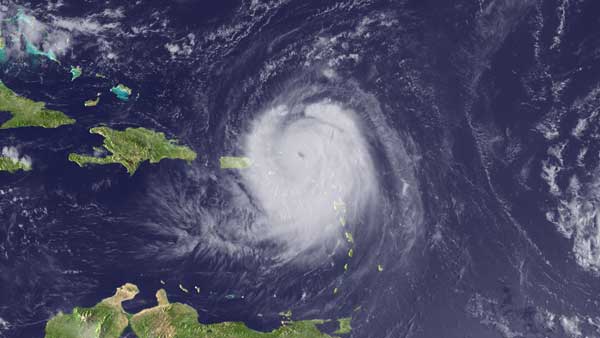
Hurricane Earl is gathering strength over the Atlantic, and NASA scientists are flying planes into the heart of the storm to catch Earl in the act of intensifying.
NASA's DC-8 plane, the largest aircraft involved in the space agency's Genesis and Rapid Intensification Processes mission, or GRIP experiment, spent Sunday zigzagging above and through Hurricane Earl.
According to the most recent report from the National Hurricane Center, Hurricane Earl is a Category 3 storm, packing winds of up to 120 mph (193 kph), a marked increased from a report issued just three hours earlier.
The hurricane hunters' flight took off from St. Croix in the U.S. Virgin Islands, but was forced to land in Ft. Lauderdale, Fla., because of poor weather conditions, said Scott Braun, a mission scientist and a research meteorologist at NASA's Goddard Space Flight Center in Greenbelt, Md. Braun is in charge of charting the DC-8's complex flight paths each day.
Braun, who was aboard the plane for Sunday's 8.5-hour flight, said the aircraft managed to get into the storm reasonably quickly after takeoff, and flew multiple passes at an average altitude of around 35,000 feet (10,668 meters).
Despite having to cut a few planned legs short because of lightning, Braun said the flight was a success.
"We got good radar data, good dropsonde data, everything went well yesterday," Braun told OurAmazingPlanet.
Get the world’s most fascinating discoveries delivered straight to your inbox.
Dropsondes are small instruments that travel aboard mini-parachutes and send back valuable data to the plane as they hurtle earthward, gathering information on everything from humidity to wind speed. Scientists load the dropsondes into a tube and shoot them out of the bottom of the DC-8 as it flies.
During yesterday's flight, crews aboard the DC-8 and even satellites overhead had a hard time pinpointing the eye of the hurricane, but scientists still managed to hit the center of the storm with a few dropsondes.
Braun said he's hopeful conditions will have changed for Monday's planned flight.
"Today [Earl] may strengthen to the point that the cloud cover that was above the eye yesterday disappears, and we get the formation of an eye that's clear all the way down toward the surface," Braun said.
Braun said Earl intensified quite a bit during Sunday's mission, which fell right in line with GRIP's goals of better understanding why some storms quickly become powerful hurricanes, while others fizzle out with relatively little drama.
For Monday's flight, the DC-8 will take off from Ft. Lauderdale and be within range of the storm in just a few hours.
"We got an outstanding data set," Braun said of yesterday's flight, "and we're hoping to repeat that today."
- A History of Destruction: 8 Great Hurricanes
- Which U.S. Cities Are Most Vulnerable to Hurricanes?
- Hurricane Hunting Tech: A Brief History
This article was provided by OurAmazingPlanet, a sister site to LiveScience.
